


California and National Drought Summary for July 30, 2024
Summary
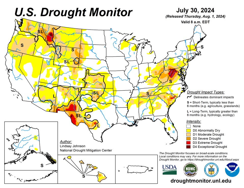
August 1, 2024 - Heat continued to be the dominating feature in the Southwest and Plains. Temperatures were 2 to 6 degrees above normal, with isolated areas seeing temperatures of 6 to 8 degrees above normal. The Southwest reached near record temperatures once again, with the highest 1-day maximum temperature for the week reaching 120 degrees in Death Valley and 110 degrees in surrounding areas. The West and Plains missed out on much of the precipitation that fell this week. These hot and dry conditions have leant themselves to increased fire potential and wildfires. The southern Plains, missing out on the precipitation and experienced above-normal temperature, leading to more drying and degradation. Similar degradations occurred along the western boarder of the High Plains due to the lack of precipitation, poor soil moisture, and declining streamflows. The Southeast on the other hand received substantial precipitation, vastly improving lingering dryness in the area. The northern Appalachian region saw 1-category degradations where streamflows in north-central West Virginia are critically low.
Northeast
Conditions continue to deteriorate across much of the Mid-Atlantic and New England regions. The Northeast largely missed out on useful precipitation, outside of isolated areas of 1-3 inches of precipitation in northern New Hampshire, central Connecticut, and the southern West Virginia and Virginia borders. Temperatures were at- or below-normal, seeing temperatures of 65 to 75 in the central and upper Northeast. New England saw the expansion of abnormal dryness from southern New Hampshire into Vermont and northern Massachusetts, along with the introduction of moderate drought conditions in southeast New Hampshire. Further south, Pennsylvania, Maryland, Virginia, and West Virginal saw 1-category expansions throughout the region due to poor soil moisture, lack of precipitation, and decreasing streamflows. Southwestern Virginia did see some of the same improvements as Tennessee and North Carolina.
Southeast
The Southeast continued to see improvements as heavy precipitation of 2 to 4 inches fell in the area. Across Alabama, Georgia, South Carolina, and North Carolina saw 150 to 400 percent of normal precipitation, leading to flooding in some areas. This brought wide-spread improvements as soil moisture and streamflows improved. The Southeast, generally, saw temperatures up to 4 degrees below normal. The southern most areas along the Gulf of Mexico and into Florida saw at- or above-normal temperatures with areas of western Florida seeing 2 to 4 degrees above normal and southeaster Georgia seeing up to 6 degrees above normal.
South
Eastern portions South saw much of the heavy precipitation seen in the Southeast. Southeastern Texas into western Louisiana recorded areas of over 8 inches of rain falling this week. There was a sharp line of where the precipitation fell and did not. West of south-central Texas, northeastward to central Arkansas saw trace amounts of rain. Temperatures were also between 1 and 4 degrees below normal, with eastern Texas and western Louisiana having temperatures of 6 to 8 degrees below normal. Except for north-central Texas and parts of Oklahoma, and western Arkansas, 1-categoy improvements were made. Oklahoma saw a mixture of above- and below-normal temperatures, with hot temperatures heating up at the end of the week (July 23 to 30). Reports of “cover crops being cooked” and “no soil moisture for native grasses to draw from and large pastures have lost much green color and have shrunk considerably” in central Oklahoma’s Logan County.
Midwest
The Midwest saw small degradations across the region despite the western and southern Midwest receiving some decent moisture. Missouri saw slight expansion of abnormal dryness along the Kansas border. Northern Wisconsin into Michigan’s Upper Peninsula saw abnormally dry conditions introduced as it missed out on meaning full precipitation, along with drying vegetation, and soil moisture. Similarly, eastern Indiana and eastern Ohio saw 1-category deterioration, with reports of crop stress and pasture issues resulting in some areas in southeast Ohio having to haul in water.
High Plains
The High Plains received trace amounts of precipitation, leading to already dry conditions in the western and southern High Plains to further deteriorate. Poor soil moisture in much of Kansas brought about widespread 1-category degradations. In eastern Kansas, along the Missouri border there have been reports dryness and heat stress. Central Kansas has also seen reports of dry ponds and fear of total crop failures. Some of these drier conditions spilled northward into southern Nebraska, which also saw areas of the northeast and western Panhandle deteriorate because of an extended period of dry conditions, dry vegetation, and low streamflow values. Similar conditions were seen across western South and North Dakota and Wyoming. Colorado saw deterioration in the northern Front Range, where extreme temperatures and low humidity made for perfect conditions for wildfires. Two fires were reported on Monday July 29: the Alexander Mountain Fire west of Loveland, the Stone Mountain Fire southeast of Estes Park.
West
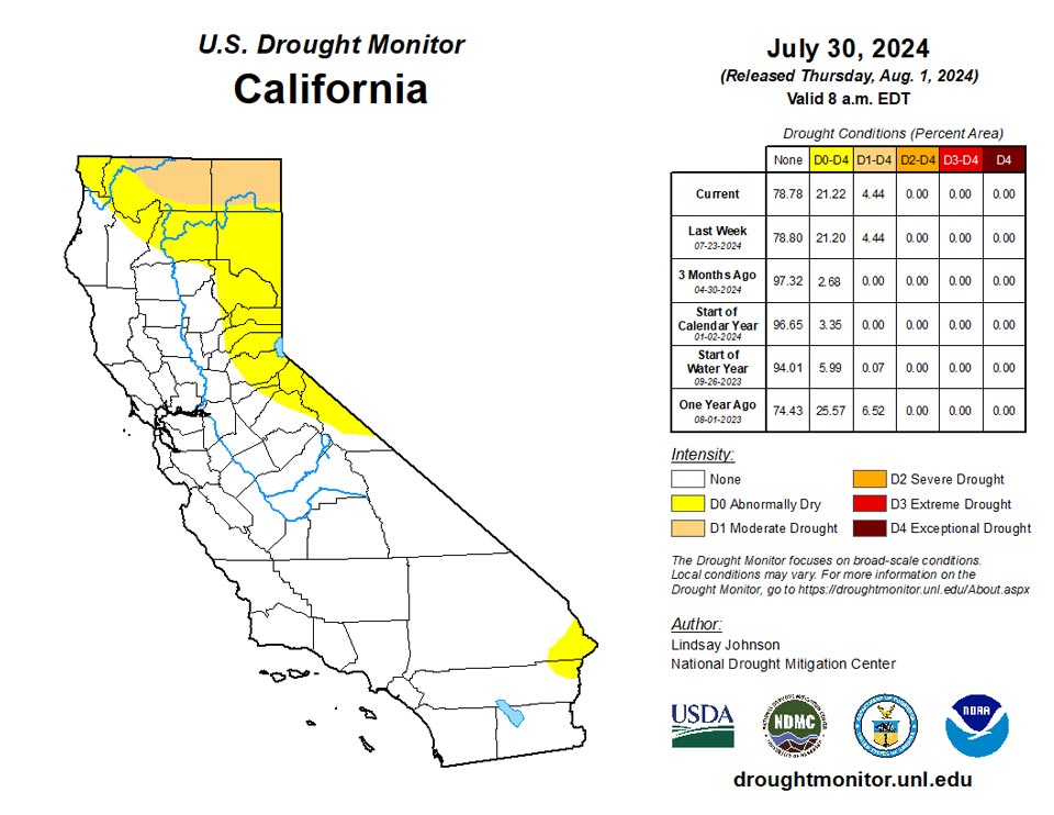
The Northwest saw some relief from the extreme heat this week, with temperatures in Nevada, California, Oregon, and Washington being 2 to 6 degrees below normal. Conversely, the Southwest saw more extreme heat. Southern California, the southern tip of Nevada, and western Arizona saw temperatures of over 90 degrees this week with the highest 1-day maximum temperature reaching over 110 degrees. In the northern West, Montana saw slight improvements in the far north where temperatures were slightly below normal but saw similar conditions as North and South Dakota conditions in the central and eastern parts of the state. Central Utah saw minor expansion of abnormal dryness as streamflow began to drop and vegetation is looking dry.
Caribbean
No changes were made in Puerto Rico.
In the U.S. Virgin Islands, occasional rain fell across St. Thomas and St. John during the drought-monitoring period ending on July 30, while generally light showers dotted St. Croix. After July 30, a large tropical wave produced rain that will be reflected in next week’s report. For this monitoring period, a network of volunteer (CoCoRaHS) observers reported rainfall ranging from 1.13 to 1.42 inches on St. Thomas; 0.42 to 2.76 inches on St. John; and 0.18 to 0.38 inch on St. Croix. Vegetation health remained good, and three U.S. Geological Survey wells – one per each major island – have exhibited relatively steady depths to groundwater over the last several weeks. The Standardized Precipitation Index continued to reflect drought-free conditions throughout the territory.
Pacific
The northeast Interior, near the Yukon Flats, received some rain leading to the removal of abnormally dry conditions. Similarly in southern Alaska, near the Alaska Range and Kenai Peninsula received enough precipitation to see the removal of abnormal dryness. Otherwise, conditions remained the same as last week due to varied precipitation.
Strong and stable trade winds blew across Hawaii this week, bringing with it relatively little rainfall on the windward slopes. Maui saw the expansion of severe drought toward the northwest along the lower elevations. The Big Island also saw the expansion of moderate and severe drought northward.
In the U.S.-Affiliated Pacific Islands, wet weather generally continued to ameliorate El Niño-induced drought conditions that had developed in the Marianas and portions of the Marshall Islands early this year, and across parts of Micronesia in late 2023 or early 2024. With an apparent transition to La Niña underway, only northern sections of the Marianas are experiencing lingering dryness, with D0 observed for Saipan. During the first 30 days of July, rainfall at Saipan International Airport totaled just 3.07 inches, 43% of normal. Meanwhile in the Republic of the Marshall Islands (RMI), Wotje has been experiencing drought since December 12, 2023, and has received measurable rain on just 4 days in July, totaling 4.03 inches, with most of the precipitation falling on the 6th and 18th. For now, Wotje remains in extreme drought (D3). Elsewhere in the RMI, Majuro reported reservoir storage topping 30 million gallons each day during July, with a value of 31.843 million gallons (88% of capacity) on the final day of the month. Farther south and west, the Federated States of Micronesia are free of dryness and drought at all reporting sites for the first time this year, due to the removal of abnormal dryness (D0) from Ulithi and Yap. Ulithi’s last date without D0 or worse was November 14, 2023; for Yap, it was December 12, 2023. Elsewhere, the Republic of Palau remained extremely wet, with July rainfall topping 20 inches in some locations, while American Samoa noted a second consecutive week of mostly dry weather. However, American Samoa experienced very wet weather in early July that has provided a buffer against developing dryness.
Looking Ahead
Over the next five days (August 1-6), the Midwest, Northeast, and eastern Southeast are expected to see 1 to 2 inches of rain with heavier amounts predicted in the eastern Midwest and southern Florida. The rest of the Southeast will see more modest amounts of precipitation, deviating from their previous weeks of heavy precipitation. There is currently an Atlantic Disturbance that the National Hurricane Center show a greater than 60 percent chance of developing into a tropical cyclone within the next two days (August 1-2) which could bring heavy rainfall along the Atlantic Coast in the coming week. Isolated areas from Wisconsin, Minnesota, and Iowa to Kansas and higher elevations of Colorado, New Mexico, and Arizona are expected to receive around 1 inch of precipitation. Otherwise, precipitation will be light and spotty leading to much of the West, Texas, southern Oklahoma and Arkansas missing out on the precipitation.
The National Weather Service Climate Prediction Center’s 6-10 day outlook heavily favors above-normal temperatures from the Pacific Northwest across to the Southeast with conditions becoming near normal across the central U.S. and leaning to below normal temperatures further north toward Canada. Much of Alaska is expected to be above normal with below-normal temperatures possible to the southwest. Similarly, Hawaii is leaning towards above-normal temperatures. Many of the lower 48 states are leaning towards above-normal precipitation, centering around Wyoming and Colorado, along with the Atlantic Coast, which could see remnants of the Tropical Disturbance currently in the Caribbean. Alaska’s border with Canada is seeing up to a 70 percent chance of below normal precipitation, with the probability increasing in the west and southwest. Hawaii probability of seeing below-normal precipitation is 33 to 40 percent.
Author(s):
Lindsay Johnson, National Drought Mitigation Center
Brad Rippey, U.S. Department of Agriculture
Dryness Categories
D0 Abnormally Dry—used for areas showing dryness but not yet in drought, or for areas recovering from drought.
Drought Intensity Categories
D1 Moderate Drought
D2 Severe Drought
D3 Extreme Drought
D4 Exceptional Drought
Drought or Dryness Types
S Short-term, typically less than 6 months (agriculture, grasslands)
L Long-term, typically more than 6 months (hydrology, ecology)
SL Area contains both short- and long-term impacts
Source: National Drought Mitigation Center
