


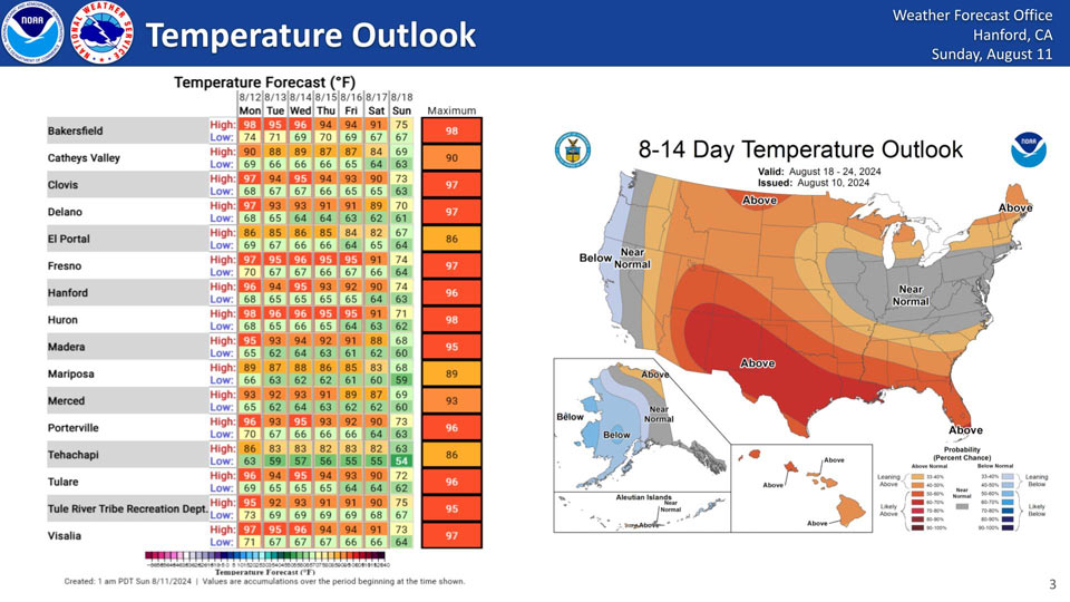
El Portal, Catheys Valley and Mariposa High Temps in the 80's
August 11, 2024 - National Weather Service Hanford Office officials report temperatures will continue to lower a couple of degrees this week across the Interior Central Valley of California and the trend is anticipated to continue through the next fourteen days.
Area Forecast Discussion
National Weather Service Hanford CA
152 AM PDT Sun Aug 11 2024
.KEY MESSAGES...
1. Temperatures will trend cooler today and lower to near
normal by Monday.
2. Based on the incoming trough, confidence is growing for a
stretch of near-normal temperatures for much of this week.
3. Despite moderating relative humidity values, the risk of
grass fires continues with elevated afternoon winds. Today and
Monday will see an increase in winds across prone areas.
&&
.DISCUSSION...IR/WV imagery showing an upper shortwave is
pushing across central CA at this time and bringing some high
clouds across the northern half of our area. It has also
prodcued some increased winds across the Tehachapi Mountains
and Mojave Desert Slopes in response to slightly increased
onshore p-grads with several stations reporting gusts between
35 and 45 mph. This aforementioned system is expected to push
further inland today and break down the large upper ridge
centered over the four corners region that has been responsible
for the widespread triple digit heat across the San Joaquin
Valley and foothill areas over the previous 8 days. This in turn
will allow for a noticable cooling trend across our area today
and Monday with daytime highs expected to lower by 2-3 DEG F
across most of our area today and by other 4-6 DEG on Monday as
an upper trough pushes into CA. As the trough moves further
inland by Tuesday, temperatures will lower to near daily
climatological normals. Will need to watch for breezy to to
windy conditions across the Tehachapi Mountains and Mojave
Desert Slopes on Monday evening as the HRRR is showing stronger
winds than the NBM has been showing.
Ensemble members are in fairly good agreement for the medium
range period with a shortwave ridge over the area on Wednesday
followed by another trough passage on Thursday. A large upper
flow is progged to move across the PAC NW region Friday through
early next week which will maintain an onshore flow pattern
over central CA with temperatures close to normal (the NBM PoE
of 100 DEG F in the San Joaquin Valley is 5 percent or less each
day) and continued dry conditions with occasional periods of
increased winds over the normally wind prone areas.
&&
.AVIATION...Areas of MVFR and local IFR visibilities will
continue in and around wildfires. Otherwise, VFR conditions will
prevail across the central CA interior over the next 24 hours.
&&
.AIR QUALITY ISSUES...None.
&&
.CERTAINTY...
The level of certainty for days 1 and 2 is high.
The level of certainty for days 3 through 7 is high.
Certainty levels include low...medium...and high. Please visit
www.weather.gov/hnx/certainty.html for additional information
and/or to provide feedback.
&&
.HNX WATCHES/WARNINGS/ADVISORIES...None.
Source: NWS
