


California and National Drought Summary for August 20, 2024
Summary
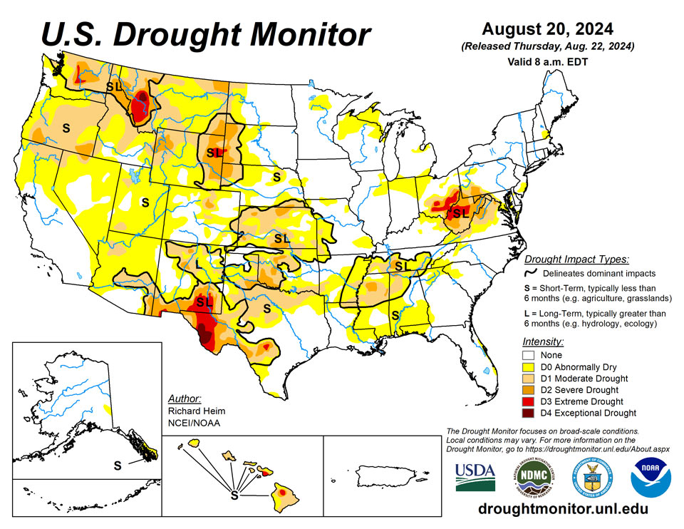
August 22, 2024 - A high-pressure ridge continued across the southern Plains during this U.S. Drought Monitor (USDM) week (August 14-20), bringing dry and very hot weather, especially to Texas. Pacific weather systems moving in the jet-stream flow brought above-normal precipitation to parts of the West Coast, the northern to central Rockies, and parts of the central to northern Plains, the Midwest, and Northeast. The rain was frequently hit-or-miss, with large parts of the Pacific Northwest to Plains, and Midwest to Northeast, receiving little to no precipitation. In addition, much of the Southwest, and southern Plains to Southeast, were drier than normal this week. An upper-level trough kept the Far West cooler than normal, while a large cold front brought cooler-than-normal temperatures to much of the Midwest to East Coast. The rain contracted drought and abnormal dryness in parts of the Rockies to central Plains, and a few parts of the Midwest and East Coast. But drought or abnormal dryness expanded or intensified in parts of the West that missed out on the precipitation, parts of the Great Plains, from the Tennessee Valley to central Gulf of Mexico coast, and parts of the Midwest to central Appalachians. The lack of rain continued to dry out soils across large parts of the West (especially the Pacific Northwest), in the southern Plains, the Lower Mississippi Valley, and central Appalachians. Numerous wildfires were burning across the West with some sparking up in the southern Plains and western High Plains. The most severe drought areas included the central Appalachians to Upper Ohio River Valley, the Rio Grande River Valley, eastern Wyoming, western Montana, and central Washington.
Northeast
Parts of the Northeast received 2 to 3 inches of rain this week while other areas received little to no rain. Connecticut and Long Island were inundated with over 5 inches. Southern and eastern parts of the region were near to cooler than normal while northern New York and northern New England were warmer than normal, with weekly temperatures averaging 2 to 4 degrees F warmer than normal. Beneficial rain this week and over the last 30 days resulted in shrinkage or elimination of abnormal dryness in New Jersey, Pennsylvania, and Maryland. Heavy rains that fell over the past month resulted in contraction of severe drought in parts of Maryland, northern Virginia, and eastern West Virginia, although it should be noted that, due to the rapid rainfall rates, much of that earlier rain ran off and agricultural impacts continue, especially in West Virginia. Some areas missed out on the rain this week and over the last several months, and this resulted in expansion of abnormal dryness in southern New Jersey and expansion of severe to extreme drought in West Virginia and severe drought in the southwest corner of Pennsylvania. In West Virginia’s core drought area, stream levels are low, soils are dry, and pastures and meadows are not regenerating, resulting in a detrimental impact upon cattle and livestock. Many farmers and ranchers are hauling water for livestock and irrigation. According to August 18 U.S. Department of Agriculture (USDA) statistics, 87% of the topsoil and subsoil in West Virginia is short or very short of moisture (dry or very dry), and 65% of the pastures and rangeland is in poor to very poor condition.
Southeast
Parts of the Southeast had 2 inches of rain this week, while other parts received little to no precipitation. Weekly temperatures were cooler than normal in the north and warmer than normal in the south, with anomalies ranging from about 2 degrees below normal in parts of North Carolina and Virginia to 2 to 4 degrees above normal in parts of Florida and Alabama. Abnormal dryness was reduced in Virginia, the Carolinas, Georgia, and Alabama, and moderate to severe drought trimmed in Virginia. But the bigger story was continued dry conditions and hot temperatures along the Gulf Coast which increased evapotranspiration and resulted in expansion of drought and abnormal dryness, especially in Alabama and the Florida panhandle. Moderate drought expanded and severe drought developed in Alabama. According to USDA reports, 47% of the topsoil and 45% of the subsoil was short to very short of moisture. Abnormal dryness also expanded along Florida’s east coast.
South
The keywords for the South region are hot and dry. Most of the region was warmer than normal, with only eastern Tennessee near normal. Parts of northern Texas had weekly temperatures 6 to 10 degrees above normal, with daily high temperatures over 100 degrees F all week and exceeding 110 on some days. Parts of Arkansas and eastern Oklahoma received over 2 inches of rain this week, with locally over 5 inches, and there was a smattering of showers in Louisiana, Mississippi, and Tennessee, with rainfall mostly half an inch or less. All of Texas and most of Oklahoma received little to no rain this week. With dry soils, high evaporation, and deficient rainfall, abnormal dryness expanded in parts of most of the South region states. Moderate drought expanded in Texas, especially in north central Texas where the fire danger was high and several large wildfires were burning; extreme drought expanded in the Texas Trans Pecos. Moderate to severe drought expanded in Oklahoma, Mississippi, and Tennessee. Abnormal dryness and moderate drought were trimmed where the heaviest rains fell in eastern Oklahoma and western Arkansas. Soils were very dry: USDA topsoil/subsoil percentages short or very short include 75%/65% for Texas, 65%/50% for Louisiana, 62%/59% for Mississippi, 53%/49% for Arkansas, 50%/52% for Tennessee, and 47%/49% for Oklahoma. Mississippi experienced a 70% loss of field corn in the east-central portion of the state during the mid-June through early July dry period. Extension agents are reporting a likely significant loss of cotton and soybeans in this region as well. Cotton plants are dying, and soybeans in many locations set pods without beans. According to the USDA Crop progress report for Mississippi, pasture land, soybeans, and cotton are currently worse than 2023 levels. In Tennessee, there were reports of a pond drying up, lack of forage growth (in June and July), and tree stress (early browning and dropping of leaves). The USDA reported 46% of the pasture and rangeland in Texas was in poor to very poor condition.
Midwest
Several areas within the Midwest region received 2 inches or more of rain this week, with Missouri experiencing the heaviest thunderstorms – locally over 6 inches. But other parts were dry, with little to no rain falling. Weekly temperatures averaged warmer than normal in the north, with parts of Minnesota 2 to 4 degrees warmer than normal, and near to above normal in southern Missouri, while the week was near to cooler than normal in between. Southeastern Ohio was the drought epicenter for the region, where abnormal dryness and moderate to extreme drought expanded. Abnormal dryness expanded in northern Indiana and northeast Illinois. But abnormal dryness and drought contracted in other areas, including Kentucky, Missouri, and Wisconsin. Drought impacts, that were reported in Ohio, include no growth on pastures, creeks and private wells running dry, low ponds, farmers and ranchers hauling water and feeding hay, some soybean and corn fields completely gone, trees losing leaves, and low intensity woodland wildfire activity. According to USDA data, 57% of the topsoil and 65% of the subsoil in Ohio is short or very short of moisture.
High Plains
Like other parts of the country, there were wet areas and dry areas this week in the High Plains region. Weekly rainfall totals ranged from zero in parts of Wyoming to locally over 2 inches in the Dakotas, Nebraska, and Kansas. Eastern parts of the Dakotas and Nebraska averaged near to cooler than normal for the week, but areas to the west and south were warmer than normal, with some areas 2 to 4 degrees above normal. There was expansion of drought and abnormal dryness in most states in the region, more in the north, and contraction in mostly southern states. The more notable changes were expansion of moderate to severe drought in Kansas and Wyoming with extreme drought being introduced in Wyoming and adjacent South Dakota, and contraction of abnormal dryness and drought in Colorado and Kansas, especially southeast Kansas where locally up to 5 inches of rain fell. Reports of significant hay loss and early cattle sales in South Dakota may be due to a combination of drought and a June 19 freeze event; other drought impacts include surface water shortage and poor water quality for livestock. According to USDA reports, in Wyoming, 75% of the topsoil moisture and 81% of the subsoil moisture are short or very short and 66% of the pasture and rangeland was rated in poor or very poor condition. More than 40% of the topsoil moisture was short or very short in Nebraska, Colorado, and Kansas, with 55% of the subsoil moisture so rated in Kansas.
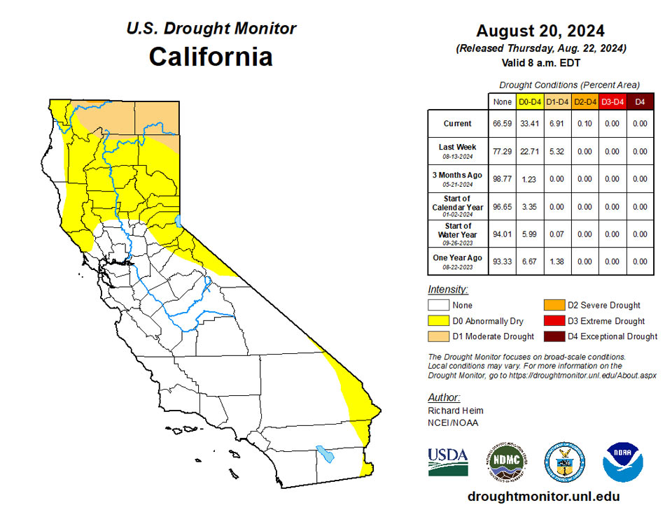
West
Half an inch of rain or more fell this week along the Washington and Oregon coast, in the Rockies, and parts of the Southwest (Four Corners States), with little to no rain falling across most of California, Nevada, and interior portions of the Pacific Northwest. Temperatures were cooler than normal in the Far West to Great Basin, averaging as low as 4 to 6 degrees below normal, but warmer than normal in southern and eastern areas, averaging 2 to locally 8 degrees above normal in Arizona, New Mexico, and Montana. Contraction of abnormal dryness or drought occurred in a few parts of New Mexico, Utah, and Montana, but drought or abnormal dryness expanded in the Pacific Northwest, California, and Nevada. The most notable changes occurred in Washington and Oregon, where moderate to severe drought expanded. More than 60% of the topsoil/subsoil moisture was rated short or very short in Oregon (81%/75%), Washington (69%/65%), Idaho (65%/62%), Montana (78%/79%), and New Mexico (70%/70%). Almost two-thirds of the pasture and rangeland was rated in poor to very poor condition in Oregon (62%) and Washington (63%).
Caribbean
Puerto Rico was warmer and wetter than normal this week. With widespread rainfall amounts over 3 inches and locally over 6 inches from Hurricane Ernesto, no change was made to the island which remains free of drought and abnormal dryness.
The U.S. Virgin Islands remained free of drought or abnormal dryness after heavy rains from Ernesto passed through. Rainfall amounts ranged from 4.89 to 6.78 inches on St. John, from 1.68 to 6.25 inches on St. Croix, and observations of 7.55 and 7.57 inches were taken on St. Thomas.
Pacific
This week was drier than normal in southern and southeast Alaska to wetter than normal to the west and north. The temperature anomaly pattern was similar: warmer than normal in the southeast to cooler than normal in the northwest. No change was made to the depiction, so moderate drought continues in southern parts of Alaska’s panhandle.
Drier-than-normal weather continued across most of Hawaii this week. Abnormal dryness expanded to the north shore of the Big Island, resulting in all of the Big Island, as well as all of the state, covered in abnormal dryness to extreme drought.
There was no drought or abnormal dryness in American Samoa this week. Weather at lower elevations such as Pago Pago was a bit drier, where rainfall totaled 0.83 inches, while Siufaga and Toa Ridges received 2.34 and 1.16 inches of rain.
Palau remained free of drought or abnormal dryness this week, where 1.4 inches of rain were reported at the cooperative observing site.
No changes were made to the Drought Monitor categories in the Mariana Islands. Saipan remained in short-term abnormal dryness after a record dry July, though the 3.17 inches of rain the island received this week have likely helped improve conditions a bit. On Rota, wetter weather continued this week with 3.53 inches of rain, and they remained free of abnormal dryness or drought. Rainfall amounts on Guam varied from over 1.56 inches to as high as 3.78 inches at a CoCoRaHs site, and they remained free of drought or abnormal dryness.
On Yap, 1.69 inches of rain fell this week after the previous two weeks recorded less than an inch of rain each. Given a wetter-than-normal July, abnormal dryness has not yet developed, though conditions have begun to dry in the short-term. Another mostly dry week occurred on Ulithi, with 0.1 inches of rain following just 0.06 inches last week, though abnormal dryness has not yet developed. On Woleai, only 0.25 inches of rain fell this week, though they remain free of drought or abnormal dryness after over 4 inches fell last week. Short-term abnormal dryness developed this week on Lukunor, Pohnpei, and Kapingamarangi, where rainfall amounts totaled 0.68, 0.76, and 1.07 inches respectively. Each island has seen at least three consecutive weeks of less than the two-inch threshold. Chuuk received 1.3 inches of rain this week after 0.39 inches last week; despite a drier two weeks, July was wetter-than-normal, and abnormal dryness has not yet developed. Nukuoro received 3 inches of rain this week following a drier last two weeks, so no abnormal dryness or drought has developed there. Pingelap received 4.26 inches of rain this week, and no drought or abnormal dryness appears to be taking place there. In Kosrae, the last couple weeks have been drier, with 1.39 inches of rain last week and 1.84 inches this week. Abnormal dryness has not yet developed, though the southern islands of Kosrae have appeared to be drier and flows have weakened on the Tofol River, so conditions are being monitored for abnormal dryness there. No data was available for Fananu, so no Drought Monitor category was assigned there.
The last couple weeks have been a bit drier on Ailinglapalap, with 1.79 and 1.43 inches of rain being reported, though abnormal dryness has not yet developed. Wotje reported 3.08 inches of rain this week and remained free of drought or abnormal dryness. Majuro saw a drier-than-normal July, though still had sufficient monthly rainfall of 8.86 inches. The beginning of August has also been a bit dry, though with 2.03 inches of rain this week, abnormal dryness has not yet developed. In Jaluit, 2.87 inches of rain fell this week after a drier last couple of weeks, and they remained free of abnormal dryness or drought. Either no data or insufficient data were available for Kwajalein, Utirik and Mili, so no Drought Monitor categories were assigned for these locations.
Looking Ahead
In the two days since the Tuesday valid time of this USDM, scattered showers and thunderstorms brought areas of rain to parts of the Southwest, Pacific Northwest, and Plains, but the rest of the contiguous U.S. (CONUS) was mostly dry. For August 22-27, the upper-level ridge will slowly shift east, bringing warmer-than-normal temperatures to much of the CONUS between the Plains and Appalachians, while an upper-level trough will move into the West, bringing cooler-than-normal temperatures. An inch or more of rain is predicted for the Cascades, much of the Southwest (Four Corners States), and parts of the northern Rockies and central Plains. A stalled frontal boundary will bring an inch to locally 3 inches or more of rain to the Florida peninsula. Half an inch of precipitation is forecast for areas in the central to northern Plains, Middle to Upper Mississippi Valley, parts of New England, and northern parts of the West. Large parts of California and Nevada, the southern Plains, and Lower Mississippi Valley to Mid-Atlantic coast can expect little to no precipitation.
For much of the next 2 weeks, the ridge and trough pattern will continue to slowly move east. The Climate Prediction Center’s (CPC) 6-10 Day Outlook (valid August 27-31) and 8-14 Day Outlook (valid August 29-September 4) favor warmer-than-normal temperatures across the CONUS east of the Rockies, shifting to the East Coast as the ridge moves east. Odds favor below-normal temperatures over the Pacific Northwest and northern Rockies at first, then over the northern Plains as the trough moves east. The West Coast and southern tier states are likely to be warmer than normal through the period. Alaska may see cooler-than-normal temperatures in the southwest to warmer-than-normal temperatures in the northeast. Odds favor below-normal precipitation across parts of the Pacific Northwest and a large area centered over the Mid-Mississippi and Ohio Valleys, while above-normal precipitation is favored from the Southwest to northern Plains and parts of the Gulf Coast states, in the northern Rockies early in the period, and along the extreme East Coast late in the period. Most of Alaska could see wetter-than-normal conditions.
Author(s):
Richard Heim, NOAA/NCEI
Curtis Riganti, National Drought Mitigation Center
Dryness Categories
D0 Abnormally Dry—used for areas showing dryness but not yet in drought, or for areas recovering from drought.
Drought Intensity Categories
D1 Moderate Drought
D2 Severe Drought
D3 Extreme Drought
D4 Exceptional Drought
Drought or Dryness Types
S Short-term, typically less than 6 months (agriculture, grasslands)
L Long-term, typically more than 6 months (hydrology, ecology)
SL Area contains both short- and long-term impacts
Source: National Drought Mitigation Center
