


California and National Drought Summary for September 10, 2024
Summary
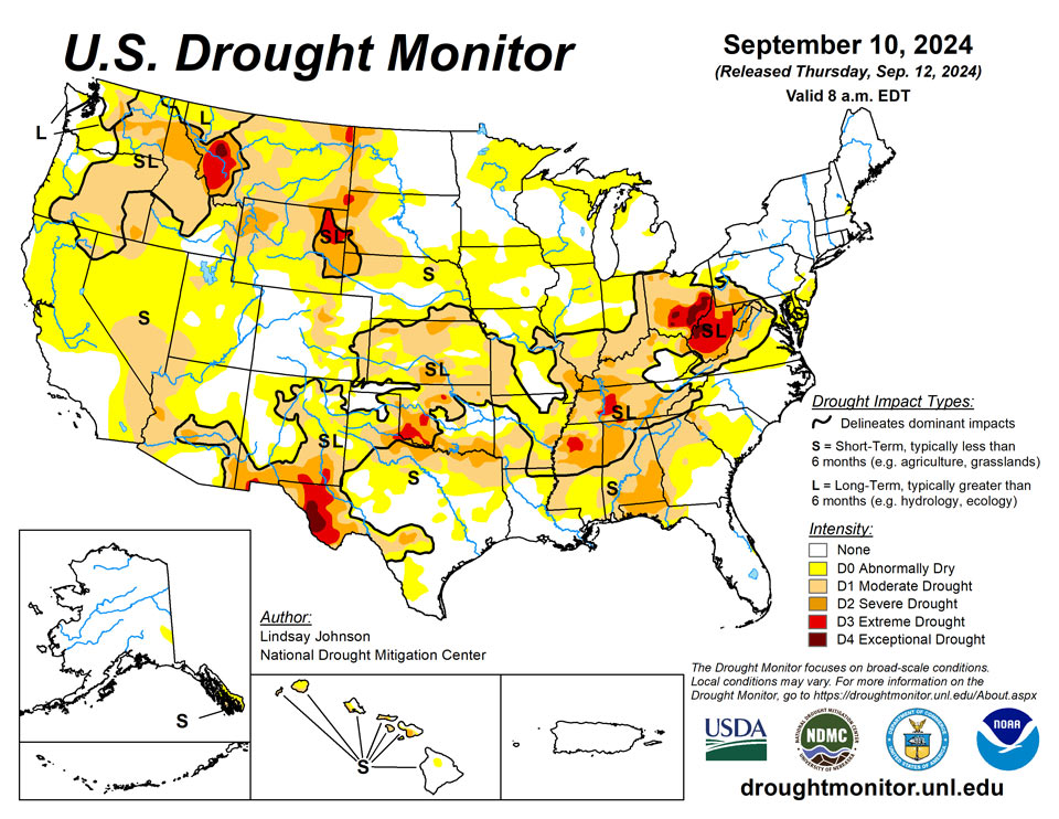
September 12, 2024 - There was a sharp difference in temperatures across the U.S. this week (Sep. 3 to Sep. 10). Temperatures in the West were above normal, whereas areas from Texas to Wisconsin and east saw temperatures of 3 to 9 degrees below normal. Very little precipitation fell, with Hurricane Francine providing most of it along the Gulf Coast. Overall, the central and eastern portions of te country saw continued deterioration, adding onto already expansive deterioration from last week. The Ohio River Basin continues to be the epicenter of the extremely dry conditions, though moderate and severe drought conditions are spreading through the southern Midwest into the Southeast. Improvements made along the Gulf Coast were primarily due to the well-above-normal precipitation brought by Hurricane Francine. There were some other areas of improvement in New Mexico, northeastern Arizona, eastern Utah, southern Wyoming and northwestern Montana. Areas of the West that have not seen any meaningful precipitation in a while are beginning to see dropping streamflows and drying soils.
Northeast
The Northeast experienced below-normal temperatures over the past week, with areas in Maine at or near normal, but West Virginia had temperatures of 6 to 10 degrees below normal. Despite the cooler temperatures, a lack of precipitation led to deteriorating conditions in West Virginia, Maryland, Delaware, far southeast Pennsylvania and New Jersey. In New Jersey, further expansion of abnormal dryness following another week without precipitation and moderate drought was introduced to southeast Burlington County. Far east Maryland, Delaware and southeast Pennsylvania saw abnormal dryness expand. West Virginia, already struggling with intense drought, had conditions further deteriorate except for some improvement in exceptional drought along the West Virginia-Ohio border. Conditions degraded toward the southeast part of the region, where precipitation remains elusive.
Southeast
The Southeast got some relief from Hurricane Francine. Only the Gulf States saw much benefit, with areas from southern Alabama to Georgia’s coast seeing 2 to 4 inches of rain (except for the Florida Peninsula, where up to 8 inches fell). Despite this strip of moisture, the region continues to be at or below normal in terms of precipitation. Temperatures across the region were well below normal, except for the Florida Peninsula. Areas that received precipitation did see some improvement. Along the Alabama-Mississippi border and the southeastern Alabama and Georgia border, one-category improvements were made. Georgia and the northern Atlantic border of Florida also saw the removal of some abnormal dryness, again due to precipitation from Hurricane Francine. Further north in the Southeast was another story, having missed out on much of the week’s precipitation. Moderate drought spread throughout the Southeast with severe drought in Alabama, the Florida Panhandle and northeast South Carolina also expanding.
South
The western portion of the South saw widespread improvements from central Texas to central Mississippi. Heavy rainfall from Hurricane Franciene dropped 2 to 6 inches of rain and the southeastern tip of Louisiana got as much as 14 inches of rain. Outside of the Gulf Coast, precipitation was lacking with precipitation hovering below normal. Temperatures were 2 to 6 degrees below normal, with localized areas being 6 to 8 degrees below normal. Central and southern Texas continued to see one-category improvements. Louisiana saw most of the abnormal dryness added last week removed due to abundant precipitation. Things started to degrade in Oklahoma, northeast Texas, Arkansas and northern Mississippi, where one-category degradations were widespread.
Midwest
The Midwest continued to observe dry conditions this week, with the only improvements found in eastern Ohio and Michigan’s Upper Peninsula where some precipitation fell. Despite the much-needed reprieve in heat, with temperatures being 2 to 6 degrees below normal for most areas, numerous cities had one of their hottest summers on record and abnormal dryness saw vast expansion. Many areas of the Midwest are now in abnormally dry or worse conditions. Kentucky, eastern Missouri, southern Illinois, southern and eastern Indiana and western Ohio all saw one-category expansions, especially moderate drought. Soil moistures in the southern and eastern Midwest are beginning to show signs of deeper level drying, with no precipitation to provide relief. Despite Ohio seeing improvement along the Ohio river, exceptional drought shifted centrally.
High Plains
The High Plains saw a mixed bag of improvements and degradations. The area remained hot and dry, except for eastern Nebraska and Kansas. Higher elevations of Colorado and Wyoming did receive some precipitation, but conditions remained mostly status quo. Kansas has experienced feast or famine precipitation since the beginning of summer. Some isolated, slow-moving thunderstorms provided good moisture in the center of the state, but abnormally dry or moderate drought conditions expanded along the Kansas western, southern and eastern borders. Eastern Colorado is beginning to show signs of a prolonged dry period, with moderate drought creeping further eastward from the Kansas border. Similarly, central and northern Wyoming are showing drier signals in the short-term, including soil moistures. These same conditions brought abnormally dry conditions along the North and South Dakota border and into southern and eastern Nebraska.
West
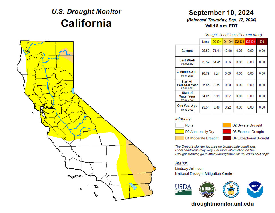
The West remained mostly dry with little to no precipitation and above-normal temperatures, except for southern New Mexico where onditions improve mainly on the residual effects of a wet few weeks and aided by below-normal temperatures. Central and northeastern Arizona into southeastern Utah also saw some improvements. Arizona also saw the expansion of moderate drought, overflowing into southern California. Central California also saw abnormally dry conditions expand. Northern Nevada, eastern Oregon and west-central Idaho saw widespread moderate drought expansion due to warm temperatures, lack of precipitation and drying soils. Washington into northwestern Idaho saw severe conditions expand, but extreme dryness was removed in Grant County, Washington as conditions were similar to the surrounding severe drought conditions.
Caribbean
No changes were made in Puerto Rico.
Rainfall totals were unremarkable across the Virgin Islands last week. Most locations reported somewhat below-normal totals between 0.3 and 0.9 inches, but 1.5 to 1.9 inches fell on some areas around Christiansted and Frederiksted on St. Croix, Bordeaux and Windswept Beach on St. John, and Charlotte Amalie on St. Thomas. These rains were sufficient to keep dryness-related impacts at bay, particularly in light of the heavy to excessive rains that pelted the region from February through August. Rainfall accumulations exceeded 30 inches throughout the U.S. Virgin Islands during this 6-month period, with amounts of 50 to 55 inches reported at some locations in and near Beth Upper New Works, Christiansted, and Frederiksted on St. Croix, and Charlotte Amalie, St. Thomas. Just over 44 inches fell on Windswept Beach, which is the highest February-August total in 40 years of records dating back to 1984, and over twice the normal of 21.7 inches.
Pacific
No changes were made in Alaska.
Conditions were generally dry and warm over the past week. Streamflow remains elevated from the Big Island to Oahu because of Hurricane Hone and the remnants of Tropical Cyclone Gilma in August. The Big Island saw one-category improvement due to Hurricane Hone. Streamflow and rainfall are near to above normal. Oahu’s August precipitation totals came in higher than expected along the Koolau Range. As a result, the central and northeast of the island saw one-category improvements. This would be consistent with streamflow data. The remaining island of Hawaii remains status quo.
The Northern Marianas remain free of any dryness or drought. The first week or so of September brought about half of normal rainfall to the island chain (generally 1.3 to 2.6 inches) as Tropical Depression 14W approached the country at the end of the forecast period. The system briefly strengthened into Tropical Storm Bebinca before being downgraded back to a tropical storm as it moved into the region. During September 10-11, Gusm International Airport reported 7.28 inches of rain, bringing their total for the first 11 days of September to almost 9 inches. Agat recorded 4.68 inches, and other locations ranged from 1.6 to 3.0 inches for the two-day period.
Tropical cyclone Bebinca also affected Palau. Koror reported 3.73 inches of rain September 10-11, which brought the September month-to-date total to 9.59 inches as (now) Tropical Depression Bebinca continued to impact the country. Palau remains free of any dryness or drought.
In western Micronesia, Yap and Woleai remained free of any dryness or drought. The first one-third of September brought below-normal rainfall to these locations, but July and August were very wet, with 32.5 and 25.3 inches of rain reported in Yap and Woleai, respectively. Meanwhile, Ulithi had been abnormally dry (D0) the previous week, but not enough data was reported to determine if conditions improved this week or not.
Farther east, across central and south-central Micronesia, heavy rains fell this past week on areas experiencing abnormal dryness or moderate drought (D0 or D1). Nukuoro had been abnormally dry, but over 5.5 inches of rain fell during the last seven days, bringing the September month-to-date total to 6.7 inches, which was enough to remove the D0 designation this week. Meanwhile, over 6.5 inches of rain soaked Kapingamaringi, prompting and improvement from moderate drought (D1) last week to abnormally dry (D0) currently. In contrast, Lukunor remained abnormally dry (D0) – unchanged from last week – but the weekly total of nearly 4.5 inches brought dryness to the brink of elimination. During April-August, Chuuk reported abundant rainfall (over 64 inches), and the wet pattern has continued through the start of September, with almost 7.3 inches reported for the first 10 days of the month. The lagoon remains free of any dryness or drought.
Below-normal rainfall again prevailed at Pohnpei in eastern Micronesia. Close to 1.85 inches of rain fell during the week, which is around half of normal and not quite enough to keep pace with water demand. As a result, abnormally dry conditions (D0) persisted. Farther east, rainfall totals have been a little more generous at Kosrae. Over 2.8 inches of rain was recorded last week, which is somewhat below normal but sufficient to keep pace with water needs. Anywhere from 10 to 23 inches of rain fell during each of the first 8 months of the calendar year, keeping the area free of any dryness-related impacts.
Across the Marshall Islands, abnormal dryness (D0) persisted at Jaluit while other locations remained free of any dryness or drought. Subnormal rainfall was reported for each of the 9 months through August. Only a little more than a foot of rain dampened Jaluit during July-August, which is only about half of normal and not sufficient to keep pace with water demand. The prevailing drier-than-normal pattern continued through last week, with only 1.25 inches of rain observed (less than half of normal). Meanwhile, subnormal rainfall was reported in Majuro during the summer months, but only August totals were insufficient to keep pace with demand, barely (7.14 inches). Last week, however, rainfall increased, with almost 5 inches reported, keeping any dryness-related impacts at bay for the time being. At Kwajalein and Ailinglapalap, a marginally drier-than-normal August followed several months of near- to above-normal rain, and last week’s totals (3.2 to 3.4 inches) were slightly above the normal (about 2.5 inches), so those locations were kept out of any dryness or drought designation. Wotje has a drier climatology than most other locations across the U.S. Affiliated Pacific Islands, and is therefore more susceptible to impactful dryness. Less than 0.7 inch of rain was measured there last week, which is notably below the normal of 1.8 inches. July and August were not especially generous with rainfall (about 11.5 inches), but amounts were a bit more than normal, so no impactful dryness is assessed there.
July was considerably drier than normal at Pago Pago, with 4.5 inches reported, but both June and August were wetter than usual (9.9 and 6.7 inches of rain, respectively). Last week, another 3.1 inches fell, which is beyond sufficient to keep pace with demand, so no dryness or drought is designated across American Samoa.
Looking Ahead
Over the next five days (September 11-16), precipitation is expected in the high elevation of Alberta Canada into Montana and Idaho, southern Arizona, and across the Gulf and southern Atlantic Coasts. Precipitation amounts of 2 to 5 inches are expected in Mississippi, northern Alabama, western Tennessee, the Florida Panhandle, and coasts of North and South Carolina.
The National Weather Service Climate Predication Center’s 6-10 day outlook heavily favors above-normal temperatures from the north-central to eastern Canadian border to Texas-Mexican border with Minnesota, Wisconsin, and Michigan 80 to 95% likely to see above normal temperatures. Conversely, southern California and Arizona are 70 to 90% likely to see below-normal temperatures. Shifting northward towards the western Canadian border, there is a change of at- or slightly below-normal temperatures. Hawaii and northern Alaska are leaning toward above-normal temperatures.
The National Weather Service Climate Predication Center’s 6-10 day outlook heavily favors above-normal precipitation in Montana and central Idaho, as well as the Atlantic Coast of Maryland, Virginia and North Carolina. Alaska and Hawaii are also leaning toward above-normal precipitation. Arizona, New Mexico, the Gulf Coast of Texas and Louisiana, and the Great Lakes region are leaning towards below-normal precipitation.
Author(s):
Lindsay Johnson, National Drought Mitigation Center
Richard Tinker, NOAA/NWS/NCEP/CPC
Dryness Categories
D0 Abnormally Dry—used for areas showing dryness but not yet in drought, or for areas recovering from drought.
Drought Intensity Categories
D1 Moderate Drought
D2 Severe Drought
D3 Extreme Drought
D4 Exceptional Drought
Drought or Dryness Types
S Short-term, typically less than 6 months (agriculture, grasslands)
L Long-term, typically more than 6 months (hydrology, ecology)
SL Area contains both short- and long-term impacts
Source: National Drought Mitigation Center
