


California and National Drought Summary for February 16, 2016
Summary
Unsettled, cold weather across the eastern half of the country contrasted with mostly dry, warm weather from the Great Plains to the Pacific Coast. Rain and northern snow fell from the central Gulf Coast into New England, though the heaviest precipitation fell outside of the driest areas. Meanwhile, unseasonably warm, locally hot conditions across Texas renewed concerns over dryness and rapidly-developing drought. Likewise, warm, dry weather returned to the West's core drought areas following recent beneficial rain and mountain snow. However, locally heavy precipitation continued in parts of the Pacific Northwest and northern Rockies.Alaska, Hawaii, and Puerto Rico
Much-above-normal temperatures prevailed over Alaska, though the state remained covered by a seasonal snowpack. In Hawaii, notably drier-than-normal conditions over the past 90 days have stressed vegetation on the Big Island and caused streamflows across the state to drop below the 10th percentile in many locations. Consequently, Moderate Drought (D1) was expanded to reflect the increasingly dry short-term conditions. In Puerto Rico, moderate to locally heavy showers (1-3 inches) in western and northern portions of the island afforded little — if any — drought relief to the Puerto Rico’s southern and eastern drought areas.Central Plains
Sunny skies and above-normal temperatures prevailed across this drought-free region. However, pockets of short-term dryness are being monitored from southeastern Colorado into southern Kansas.Delta
Scattered, locally heavy showers helped prevent a more widespread expansion of Abnormal Dryness (D0). Rain was heaviest from southern Arkansas into northern Mississippi, where amounts totaled 2 to 4 inches. Nevertheless, drier-than-normal conditions persisted across Louisiana, where 90-day rainfall has totaled locally less than 60 percent of normal.Mid-Atlantic and Northeast
Despite widespread rain and snow, Abnormal Dryness (D0) and Moderate Drought (D1) persisted in New England and the central Appalachians. The heaviest precipitation generally bypassed the driest areas, though some small reductions were made to the D0 in southwestern Pennsylvania and northern West Virginia. Temperatures were well below normal during the period, minimizing the impacts of lingering dryness.Midwest and lower Ohio Valley
Cold, mostly dry conditions prevailed in this drought-free region.Northern Plains
Spring-like warmth was observed over the northern Plains. While precipitation was observed across much of the region, amounts were insufficient to offer relief from Abnormal Dryness (D0) and Moderate Drought (D1).Southeast
Chilly, unsettled conditions kept the Southeast free of drought. Lingering Abnormal Dryness (D0) remained over southern Georgia, but impacts were minimal if any.Southern Plains and Texas
Increasingly warm, locally hot weather coupled with a lack of rain resulted in rapidly increasing Abnormal Dryness (D0) and Moderate Drought (D1) over much of central and southern Texas. Temperatures averaged locally more than 10°F above normal, with daytime highs topping 80°F across much of the state; readings eclipsed 90°F in far southern Texas, establishing record high temperatures for the date in some locations. Over the past 60 days, precipitation has totaled less than 50 percent of normal (locally less than 25 percent) across the state's new D1 areas, with the most widespread pronounced short-term deficits noted just north of Austin.Western U.S.
Drier- and warmer-than-normal conditions overspread much of the West, with precipitation confined to the Pacific Northwest and northern Rockies. Despite the mostly favorable Water Year precipitation to date, the warmth and dryness renewed concerns of early snowmelt in the mountains; however, rain and mountain snow were returning at the end of the weekly drought assessment period (which ends Tuesday morning, 7 a.m., EST).In northern portions of the region, additional rain and mountain snow continued the favorable Water Year and resulted in further drought reductions in southwestern Oregon and western Montana. Mountain Snow Water Equivalents (SWE) continued to improve in western Montana; however, SWE values remain below average east of Flathead Lake, and the eastern slopes of the northern Rockies will need to be closely monitored over the coming weeks. Likewise, snowpack SWE remain unfavorably low in Wyoming’s Bighorn Mountains (50-70 percent of average) and River Range (60-75 percent of average, but locally less than 50 percent). These areas too will need to be followed closely throughout the second half of the Water Year.
Farther south, there were no changes to the drought depiction from the Great Basin into the Four Corners Region. In the areas of Moderate to Severe Drought (D1 and D2) around Great Salt Lake, precipitation since the beginning of the Water Year has been generally favorable, with mountain SWE currently near to above average. However, reservoir storage in these aforementioned areas hovered near or below 60 percent of average for the date, reflecting the lingering impacts of the region’s long-term drought.
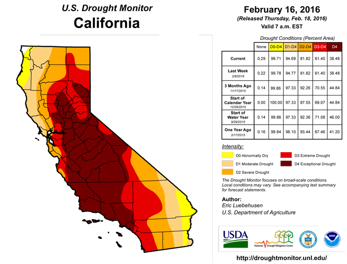
In the core western drought areas of California and western Nevada, dry, warm weather during the period resulted in no change to this week’s drought depiction. While much of the region has experienced favorable precipitation during the 2015-16 Water Year — and subsequent removal of the “S” (short-term) drought Impact Type — considerable long-term (L) impacts remain. Furthermore, there are notable pockets of short-term dryness over central and southern California contributing to the long-term drought signal. While current SWE in the Sierra Nevada are near to above average, most reservoirs on either side of the mountains remain well below average. Adding to the drought are localized areas where it has been a drier-than-normal Water Year to date; counties near and west of Sacramento have averaged 60 to 75 percent of normal precipitation since October 1, while coastal locales from Los Angeles north to Santa Barbara have reported on average 35 to 50 percent of normal rainfall during the current Water Year.
Looking Ahead
Mild weather will expand to cover much of the nation, including the previously cold eastern U.S. Warm weather will continue to set high-temperature records across the nation’s mid-section, with warmth peaking in many areas on February 18. On that date, high temperatures could reach 90°F on the southern High Plains. At the height of the southern Plains’ warm spell, gusty winds and dry conditions will lead to an enhanced risk of wildfires. Dry weather will prevail during the next 5 days across the Deep South, as well as the central and southern Plains. In contrast, precipitation totaling 2 to 6 inches — much of which will fall on February 17-18 — can be expected in parts of northern California and the Pacific Northwest. Toward week’s end, snow can be expected from the upper Great Lakes into northern New England, while rain showers will develop from the mid-South into the Ohio Valley. The NWS 6- to 10-day outlook for February 23 – 27 calls for above-normal temperatures across much of the western and central U.S., with cooler-than-normal conditions largely confined to the Southeast. Meanwhile, below-normal precipitation is anticipated from southern California and the Great Basin eastward into the Corn Belt and Great Lakes, encompassing the Rockies and Plains. Wetter-than-normal conditions will be confined to coastal areas of the Pacific Northwest and from the eastern Gulf Coast States into New England.Author(s):
Eric Luebehusen, U.S. Department of Agriculture
Dryness Categories
D0 ... Abnormally Dry ... used for areas showing dryness but not yet in drought, or for areas recovering from drought.Drought Intensity Categories
D1 ... Moderate DroughtD2 ... Severe Drought
D3 ... Extreme Drought
D4 ... Exceptional Drought
Drought or Dryness Types
S ... Short-Term, typically <6 months (e.g. agricultural, grasslands)L ... Long-Term, typically >6 months (e.g. hydrology, ecology)
Source: National Drought Mitigation Center
