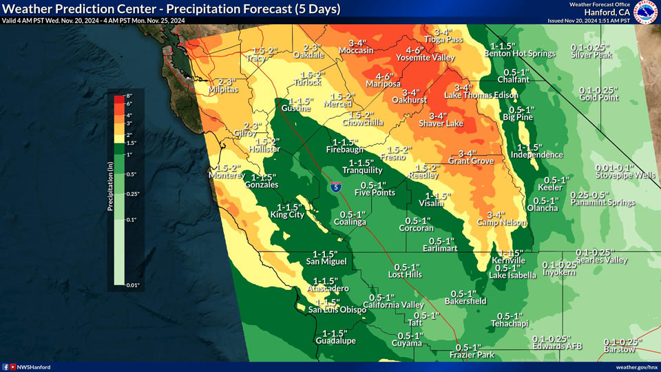
Mariposa and Yosemite Valley projected rainfall amounts: 4.00" to 6.00"
Oakhurst: Projected rainfall amounts: 3.00" to 4.00"
November 20, 2024 - National Weather Service Hanford Office officials report a range of between 1-2 inches of rain in the San Joaquin Valley this weekend with 2-4 inches in the Sierra Nevada below 8,000 feet, including the foothills.
Around 0.5-1 inch of rain is forecast for portions of Kern County with up to 0.25 of an inch across the Mojave Desert.
Area Forecast Discussion
National Weather Service Hanford CA
250 AM PST Wed Nov 20 2024
.KEY MESSAGES...
1. Temperatures will trend warmer for the rest of the work week.
Highs across the San Joaquin Valley will be around 2 to 5
degrees above normal today and then around 5 to 50 degrees above
normal Thursday and Friday.
2. A strong winter storm system is forecast to impact Central
California Friday night through this weekend. Portions of the
San Joaquin Valley and the Sierra Nevada Foothills may see
moderate to heavy rainfall at times with moderate to heavy
snowfall in the Sierra Nevada above 8000 feet.
3. The probability of receiving one-half (0.5) inches of rain by
4 PM Saturday is 90% in Merced decreasing towards the south to
75% in Fresno, 50% in Visalia, and 20% in Bakersfield.
4. The snow level will be around 8,000 feet on Friday lowering
near 7,000 feet around Yosemite NP by Saturday afternoon. The
probability of receiving 12 inches of snow by 4 PM Saturday is
65% for Tuolumne Meadows and 85% for Tioga Pass.
&&
.DISCUSSION...
Zonal flow is currently influencing Central California through
today, with high cirrus clouds being brought into the region
from the winter storm system to the northeast. Moving into this
afternoon, slight ridging will begin, leading to an increase in
temperatures for our area today, with highs about 2 to 5 degrees
above normal. The ridge is expected to build through Thursday
and Friday, leading to a further increase in temperatures for
the region. Expect highs to be about 5 to 10 degrees above
normal on those days.
The main event for this week is expected to begin Friday evening
and is forecast to ramp up through Saturday. The San Joaquin
Valley and Sierra Nevada Foothills may see moderate to heavy
rainfall at times over the weekend. Current probabilities for
the Sierra Nevada Foothills are 30-50% for 2 inches of rain or
more in the areas north of Oakhurst, increasing as you look to
the north. Something similar can be observed for the Valley
rain probabilities, where locations to the north of Fresno have
a 55-75% chance for 0.75 inches or more, and location south of
Fresno have a 20-50% chance for 0.5 inches or more. The Sierra
Nevada mountains are also expected to see moderate to heavy
snowfall during the event, with snow levels expected to start at
8,000 feet on Friday before lowering to 7,000 feet. Current
probabilities for snow on Saturday afternoon are 65% for
Tuolumne Meadows and 85% for Tioga Pass. Then as much as 2 feet
of snow may fall on the highest peaks, with a 40-60% chance for
24 inches at the highest elevations on Saturday afternoon.
This precipitation rate is expected to continue through at
least Sunday afternoon. Then light to moderate precipitation is
expected to take over and continue through early next week, with
the Valley seeing a 25-45% chance for a 0.25 inch of rain on
both Monday and Tuesday of next week. The Foothills also show
continued rain, with Monday and Tuesday probabilities of a half
inch of rain at 45-55%. Light to moderate snow can also be
expected for the Sierra Nevada mountains, with the probabilities
of an additional 6 inches of snow are 40-60% on both Monday and
Tuesday.
&&
.AVIATION...
VFR conditions will prevail thru the period at all terminals.
&&
.AIR QUALITY ISSUES...
On Wednesday November 20 2024, Fireplace/Wood Stove Burning Status
is: No Burning Unless Registered in Fresno, Kern, Madera, and Tulare
Counties. Burning Discouraged in Kings and Merced Counties, and Kern
(Greater Frazier Park Area) and Sequoia National Park and
Forest.
&&
.CERTAINTY...
The level of certainty for days 1 and 2 is medium.
The level of certainty for days 3 through 7 is medium.
Certainty levels include low...medium...and high. Please visit
www.weather.gov/hnx/certainty.html for additional information
and/or to provide feedback.
&&
.HNX WATCHES/WARNINGS/ADVISORIES...
None.
Source: NWS


