


California and National Drought Summary for March 22, 2016
Summary
March 24, 2016 - Storms continued to chip away at drought across northern California and the Northwest, while short-term dryness led to further moderate (D1) drought expansion in the southwestern and south-central U.S. During the 168-hour drought-monitoring period, ending on the morning of March 22, some of the heaviest precipitation fell in non-drought areas of the South, Pacific Northwest, and upper Great Lakes region. However, the Northwestern precipitation reached southward and inland, targeting parts of northern California and the northern Rockies. Farther east, snow grazed a portion of the Northeastern dry (D0) region on March 21, while periodic but widely scattered showers and thunderstorms dampened the lower Southeast. Elsewhere, short-term dryness began to intensify across the southwestern and south-central U.S., where until recently crops such as winter wheat had been growing well and rangeland and pastures had not been experiencing much stress. However, that has started to change as short-term dryness, aggravated by high winds and temperature extremes, has reduced soil moisture and begun to stress crops.Northeast
An Atlantic coastal storm grazed New England on March 21, producing some heavy snow that just clipped the existing area of dryness (D0). Due to the snow, there was an almost imperceptible decrease in D0 coverage. In New Hampshire, Portsmouth reported a 6-inch snow depth on the morning of March 21.Southeast
A slowly intensifying 2- to 3-month dry spell has led to an increase in the coverage of abnormal dryness (D0) in an area centered on the Georgia-South Carolina line. During the drought-monitoring period, very warm weather was followed by cooler conditions. Daily-record highs for March 15 included 89°F in Montgomery, AL; Tupelo, MS; and Daytona Beach, FL. The parade of Southeastern records continued on March 16 with highs of 90°F in New Bern, NC, and 88°F in Danville, VA, and Charleston, SC. New Bern also tied a monthly record, previously attained on March 8, 1974, and March 30, 1985. In Georgia, Savannah posted consecutive daily-record highs of 87°F on March 15-16.From January 1 – March 22, precipitation in Georgia totaled 6.90 inches (63% of normal) in Augusta and 7.42 inches (62%) in Macon. Farther south, enough rain fell in the abnormally dry (D0) area across southeastern Georgia and northern Florida to prevent expansion, but showers were not heavy enough to reduce D0 coverage.
Southern and Central Plains
Development of short-term dryness (D0) and moderate drought (D1) became more apparent across portions of the central and southern Plains, especially when windy weather resulted in a sharp increase in grassfires and blowing dust on March 22-23. A particularly severe wildfire flared in Woods County, Oklahoma, on March 22, later racing into neighboring Kansas. During the fire’s resurgence on March 23, aided by wind gusts above 60 mph, a large plume of smoke—easily visible on satellite imagery—raced northward across central Kansas.According to USDA, nearly half of the topsoil moisture was rated very short to short on March 20 in Kansas (46%) and Oklahoma (43%). A week ago, on March 13, topsoil moisture was just 37% very short to short in Kansas. Still, the majority of the winter wheat crop was rated in good to excellent condition on March 20 in Oklahoma (63%) and Kansas (57%). The Texas winter wheat crop was rated 47% good to excellent on the 20th.
Complicating matters for winter wheat is that a significant freeze struck portions of the central and southern High Plains on March 20, with low temperatures ranging from 5 to 20°F in some of the coldest locations in southeastern Colorado, southwestern Kansas, western Oklahoma, and northern Texas. Ultimately, it may be difficult to determine whether damage, if any, to the winter wheat crop was caused by freeze injury or by drought. The freeze was immediately followed by a warm, windy spell; Garden City, Kansas, reported a high of 88°F on March 22, just 2 days after a daily-record low of 10°F.
Unless significant precipitation occurs soon, a much broader area of the central and southern Plains, extending eastward into the middle Mississippi Valley, may be ripe for expansion of dryness and drought during the next few weeks. Many of these areas received extremely heavy precipitation as recently as late December, and the landscape still retains a “memory” of this rain in the form of subsoil moisture and streamflow that has only recently begun to diminish.
Northern Plains
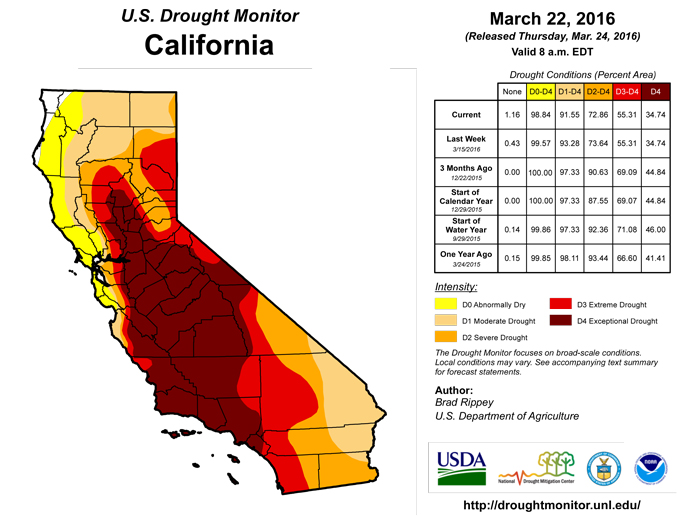
Cooler weather arrived across the northern Plains, following spring-like warmth. A pesky storm system over the upper Great Lakes region produced widespread, generally light precipitation, including some snow. Precipitation in northern Minnesota was heavy enough to trim the coverage of abnormal dryness (D0). Most other areas remained unchanged, except for a small D0 increase in western Minnesota.California
Following northern California’s heavy precipitation events of March 4-7 and 11-14, dry weather returned across much of the state for several days. However, additional precipitation fell across northern California from March 20-22, providing further incremental drought relief. Specifically, some abnormal dryness (D0) and moderate to extreme drought (D1 to D2) was trimmed from the edges, largely due to robust streamflow and reservoir recharge.During northern California’s spate of heavy precipitation, the Yuba County community of Strawberry Valley—nestled in the Sierra Nevada foothills at an elevation of about 3,800 feet—collected 11.04 inches of rain in a 72-hour period from March 4-7, followed by 10.44 inches in another 72-hour period from March 11-14. Higher elevations have received substantial snow; the average water content of the high-elevation Sierra Nevada snowpack has increased to 25 inches, up from 20 inches from the beginning of March. The 25-inch snow-water equivalency translates to 90% of the historical average as the traditional peak snowpack date of April 1 approaches. Snowpack is roughly average in the northern Sierra Nevada, but only about three-quarters of average in the southern Sierra. This is consistent with the winter 2015-16 storm track that has been more active across northern California and the northwestern U.S.
From a water-supply perspective, the favorable news is that there is a nearly normal snowpack to melt off, in addition to the fact that the state’s reservoirs had already received nearly 6.5 million acre-feet of inflow by February 29. (This figure does not include any March inflow, which has been substantial in northern California.) In a typical recharge season, California’s reservoir inflow is about 8.2 million acre-feet; thus, even without factoring in March inflow and future snow-melt runoff, California has already received more than three-quarters (6.5 of 8.2 million acre-feet) of its average seasonal allotment of surface water.
However, the improvement has not been evenly distributed, with long-term severe to extreme (D3 to D4) drought still entrenched across much of central and southern California, as reflected by less frequent storms during the 2015-16 wet season; still-low reservoir levels; less robust mountain snowpack; and continuing groundwater shortages.
Northwest
The latest parade of Pacific storms brought further relief from lingering dryness (D0) and drought (D1-D2) in the Northwest. Additional improvement was noted as far south as the northern tier of Nevada, where some trimming of moderate to severe drought (D1 to D2) in part resulted from strong streamflow in smaller creeks and rivers, as well as an increased risk of spring snow-melt flooding.Farther north, dryness (D0) and moderate to severe drought (D1 to D2) were reduced by varying degrees in Idaho, Montana, Oregon, and Washington. Notably, substantial dryness In Idaho was eliminated due to good reservoir recharge and snowpack accumulation that in most basins is coming close to, and in some cases has passed, the median annual peak value for the period of record. In addition, the latest batch of storms produced some heavy precipitation across the northern Rockies and environs. In western Montana, one of the remaining islands of moderate to severe drought (D1 to D2) was slightly realigned to better match existing snowpack deficits along the eastern slopes of the Continental Divide.
Southwest
Similar to the central and southern Great Plains, dryness and drought has quickly begun to ramp up across the Southwest. Most of the major changes to the depiction occurred in Arizona and New Mexico; both states experienced large increased in the coverage of dryness (D0) and moderate drought (D1). For the Southwest, a complicating factor is that February and March warmth has prematurely melted high-elevation snowpack in many basins. This has resulted in favorable spring streamflow that cannot be sustained as snowpack disappears. In recent days, warm, windy conditions have led to wildfires and blowing dust. While fires and dust sometimes occur due to atmospheric factors independent of drought, short-term precipitation deficits have contributed to the recent increase of both. By the afternoon of March 23, the Baker Canyon fire northeast of Douglas, Arizona, had charred more than 5,000 acres of vegetation.Alaska, Hawaii, and Puerto Rico
Parts of Alaska finally experienced colder weather. With the cool conditions came some precipitation; Anchorage received 6.4 inches of snow on March 19. However, east-central and northern Alaska’s existing abnormally dry (D0) areas experienced mostly dry weather, resulting in no change to the depiction.In Hawaii, a general increase in shower activity provided some beneficial moisture, but not in the driest areas. On Oahu, further deterioration of vegetation condition led to a northeastward expansion of moderate drought (D1) into the southern slopes of the Koolau Range.
In Puerto Rico, a small area of abnormal dryness (D0) was shaved away from the northeastern part of the island, based on recent rainfall and a lack of longer-term precipitation deficits. In San Juan, March 1-22 rainfall totaled 1.43 inches (108% of normal), while the year-to-date precipitation of 6.91 inches was 93% of normal.
Looking Ahead
During the next 5 days, from March 24-28, an active weather pattern will cover many parts of the nation. A spring storm will cross the Midwest on Thursday and northern New England on Friday. Heavy snow will end early March 24 across the upper Midwest but continue across parts of Wisconsin and Lower Michigan. Meanwhile, locally severe thunderstorms can be expected across the South through March 24, possibly as far north as the Ohio Valley. During the weekend, a new storm system will emerge from the Rockies and begin to develop across the nation’s mid-section, trailed by a surge of cold air. The track of the second storm is expected to be farther south than the earlier system, possibly resulting in beneficial precipitation across the south-central U.S. In contrast, dry weather will prevail through March 28 in southern California and the Desert Southwest.The NWS 6- to 10-day outlook for March 29 – April 2 calls for the likelihood of near- to above-normal temperatures across the eastern half of the U.S. and in the Pacific Northwest, while colder-than-normal conditions can be expected across the remainder of the West. Meanwhile, near- to above-normal precipitation in most of the country should contrast with drier-than-normal weather across the southern High Plains, northern California, and the Pacific Northwest.
Author(s):
Brad Rippey, U.S. Department of Agriculture
Dryness Categories
D0 ... Abnormally Dry ... used for areas showing dryness but not yet in drought, or for areas recovering from drought.Drought Intensity Categories
D1 ... Moderate DroughtD2 ... Severe Drought
D3 ... Extreme Drought
D4 ... Exceptional Drought
Drought or Dryness Types
S ... Short-Term, typically <6 months (e.g. agricultural, grasslands)L ... Long-Term, typically >6 months (e.g. hydrology, ecology)
Source: National Drought Mitigation Center
