


California and National Drought Summary for March 29, 2016
Summary
March 31, 2016 - The bulk of the precipitation that occurred during the 168-hour (March 22-29) monitoring period did not fall in areas experiencing dryness (D0) or drought (D1 or worse). Some of the heaviest precipitation soaked non-drought areas of the lower Southeast and the Pacific Northwest. And, a late-season snowstorm from the central Rockies into northern Lower Michigan also fell mostly “between the drought lines.” However, some of the Southeastern rain chipped away at D0 across southern Georgia and northern Florida. And, stormy weather in the Northwest pushed far enough inland to further dent lingering drought. In contrast, breezy, mostly dry weather covered the central and southern Plains and the Southwest, leading to further expansion of D0 and D1. On the southern High Plains, a combination of weather extremes—including developing drought, hard freezes, and large temperature oscillations—led to an increase in stress on rangeland, pastures, and winter wheat.Northeast
A few showers crossed the Northeast, but the general trend across the northern Mid-Atlantic States and southern New England was toward drier-than-normal conditions and below-average streamflow. Some of the low streamflow values can be explained by the lack of late-season snow and a warm spring that has accelerated vegetative demands for soil moisture. Coverage of abnormal dryness (D0) was slightly expanded in a narrow strip from the central Appalachians into southern New England, reflective of precipitation deficits at multiple time scales.Southeast
Rain soaked portions of southern Georgia and northern Florida, leading to a decrease in the coverage of abnormal dryness (D0). Savannah, Georgia, reported a daily-record rainfall total of 3.98 inches on March 27. Farther north, however, showers were spotty and failed to curb the expansion of D0 from central Georgia into parts of southwestern and south-central North Carolina. In addition, a new spot of D0 was introduced in an area centered on northwestern Alabama.Within the D0 area across the interior Southeast, dry March conditions have “allowed farmers to plow and prepare fields for upcoming planting,” according to the U.S. Department of Agriculture. This is indicative of Southeastern fields being able to support heavy equipment at an unusually early date. In addition, Southeastern streamflow has been declining at many gauge sites. Within the D0 area, Charlotte, North Carolina, received just 7.61 inches of precipitation (73% of normal) during the first 89 days of the year. Only 20 times since 1879 has Charlotte’s January-March precipitation totaled less than 8 inches. In addition, Charlotte received rainfall totaling only 0.83 inch during the first 29 days of March. The last time Charlotte recorded less than an inch of March rainfall was 1985, when 0.58 inch fell. Meanwhile in Macon, Georgia, January 1 – March 29 rainfall totaled 8.32 inches (65% of normal).
Southern and Central Plains
Development of short-term dryness (D0) and moderate drought (D1) continued across Kansas, Oklahoma, northern and western Texas, eastern New Mexico, and southeastern Colorado. On March 22-23, the Anderson Creek fire rapidly spread across Woods County, Oklahoma, and Comanche and Barber Counties in Kansas, destroying 16 residences and more than two dozen structures, and charring an estimated 367,620 acres of grass, brush, and other vegetation. Cooler, more humid weather arrived by March 24, aiding wildfire containment efforts.According to USDA, nearly half of the topsoil moisture was rated very short to short on March 27 in Kansas (48%) and Oklahoma (43%). In Texas, statewide topsoil moisture rated very short to short increased to 40% on March 27, up from 24% the previous week. And, topsoil moisture ranged from 68 to 70% very short to short in Texas’ three westernmost regions: Northern High Plains, Southern High Plains, and Trans-Pecos.
Amid the expanding D0 and D1, snow fell in some areas on March 26-27, totaling 3.5 inches in Wichita, Kansas, and 1.3 inches in Amarillo, Texas. However, the snow melted within hours, followed by a return to warm, windy conditions late in the drought-monitoring period.
In addition, D0 crept eastward into the middle Mississippi Valley. In areas where little precipitation has occurred since the beginning of 2016, signs of short-term dryness are becoming more apparent in the form of reduced streamflow, shrinking stock ponds, and dry topsoil. In Missouri, parts of which experienced record flooding as recently as late December, USDA reported that “some producers expressed concern about the lack of rain and dry conditions.” Missouri’s topsoil moisture was rated 20% very short to short on March 27.
Northern Plains
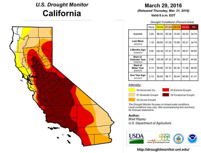
Significant precipitation remained mainly south of existing areas of dryness (D0) and moderate drought (D1) across the northern Plains. As a result, the depiction was mostly unchanged. However, there was a slight increase in D0 coverage in northeastern and south-central South Dakota, reflective of precipitation deficits at time periods out to 3 months. In Aberdeen, South Dakota, year-to-date precipitation through March 29 was less than half of normal (0.98 inch, or 47% of normal).California
A little more trimming of dryness (D0) and moderate drought (D1) occurred across northwestern California, where water-storage and streamflow indicators continue to show that drought has been sharply scaled back or eliminated. For the remainder of the state, the return of dry weather meant that the drought depiction was effectively unchanged from last week as the traditional peak snowpack date of April 1 approaches. According to the California Department of Water Resources, the average water content of the high-elevation Sierra Nevada snowpack currently stands at 24 inches, about 87% of average. However, the snowpack is 97% of average in the northern Sierra Nevada, but just 72% of average in the southern Sierra Nevada, reflective of the “northern” storm track that has been a hallmark of the 2015-16 winter wet season.Northwest
Widespread storminess ended as the drought-monitoring period began. However, on the strength of earlier precipitation and diminishing drought impacts, the drought situation further improved across Oregon and environs. Specifically, drought was completely removed from Washington for the first time since December 31, 2013, whiles severe drought (D2) was significant scaled back across southeastern Oregon.Late in the drought-monitoring period, stormy weather returned to portions of the interior Northwest. Small reductions in the coverage of dryness (D0) and moderate to severe drought (D1 to D2) were noted across the northern Rockies. However, much of the storm unfolded across Wyoming and environs after the monitoring period ended on the morning of March 29 and will be reflected on next week’s map. On March 28, daily-record snowfall totals in Nevada included 13.0 inches in Ely and 6.8 inches in Reno. The following day in Wyoming, record-setting snowfall totals for March 29 reached 15.3 inches in Lander and 8.8 inches in Riverton.
Southwest
Dry weather dominated the Southwest, although some rain and snow showers fell across the northern half of the Four Corners States (e.g. portions of Colorado and Utah). Following last week’s large increases in coverage of Southwestern dryness (D0) and moderate drought (D1), changes were mostly limited to a slight D0 expansion in the Four Corners region and some new D0/D1 coverage in southern and eastern New Mexico. Before being mostly (90%) contained, the Baker Canyon fire northeast of Douglas, Arizona, scorched nearly 8,000 acres of vegetation near the Arizona-New Mexico line. In addition, periods of wind weather continued to raise Southwestern dust, especially on March 22-23 and 29.Alaska, Hawaii, and Puerto Rico
Warm weather returned to Alaska, while significant precipitation was mostly confined to the state’s southern tier. Anchorage noted a trio of daily-record highs (49, 50, and 51°F) from March 22-24. The depiction, which includes abnormal dryness (D0) in parts of northern and east-central Alaska, remained unchanged.Beneficial precipitation spread across Hawaii on March 24-25, generally stabilizing the drought situation. Rainfall amounts were highest across the western islands, but no changes were made to the drought depiction due to still-large precipitation deficits over the last 3 to 4 months. On Kauai, windward slopes received as much as 5 to 10 inches of rain in a 24-hour period. Elsewhere, March 25 rainfall totals reached 2.59 inches in Lihue, Kauai, and 1.37 inches in Kahului, Maui. Showers were not as heavy on the Big Island, where Hilo’s year-to-date rainfall through March 29 stood at 9.45 inches (30 percent of normal). Similarly, the January 1 – March
In Puerto Rico, shower activity was not particularly heavy but sufficient for status quo—no change to the drought depiction. San Juan received measurable rain each day from March 22-28, totaling 0.69 inch.
Looking Ahead
A storm system will cross the Great Lakes region on March 29, producing a mix of rain and snow. The storm’s trailing cold front will reach the Atlantic Seaboard on March 30, but should stall across the lower Southeast. Precipitation totals associated with the storm (and its cold front) could reach 2 to 5 inches—in the form of heavy showers and locally severe thunderstorms—across the Southeast, and 1 to 2 inches along and north of the path of the low-pressure system. During the first few days of April, warm, dry weather will dominate the West, while a blast of cold air and snow showers will engulf the Great Lakes and Northeastern States. During the next 5 days, the southern Plains will remain mostly dry with rapid temperature fluctuations.The NWS 6- to 10-day outlook for April 5 – 9 calls for the likelihood of above-normal temperatures from the Pacific Coast to the Plains, while colder-than-normal conditions will dominate the eastern U.S.—especially the Northeast. Meanwhile, near- to below-normal precipitation in many areas of the country will contrast with expectations for wetter-than-normal weather across the Great Basin and neighboring areas, as well as the Great Lakes region and the Northeastern and Mid-Atlantic States.
Author(s):
Brad Rippey, U.S. Department of Agriculture
Dryness Categories
D0 ... Abnormally Dry ... used for areas showing dryness but not yet in drought, or for areas recovering from drought.Drought Intensity Categories
D1 ... Moderate DroughtD2 ... Severe Drought
D3 ... Extreme Drought
D4 ... Exceptional Drought
Drought or Dryness Types
S ... Short-Term, typically <6 months (e.g. agricultural, grasslands)L ... Long-Term, typically >6 months (e.g. hydrology, ecology)
Source: National Drought Mitigation Center

