


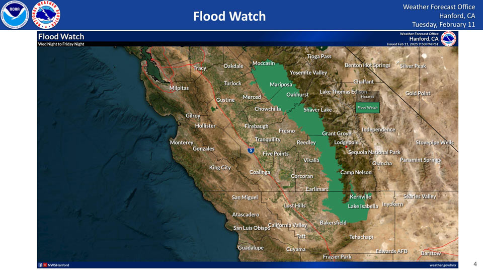
Flood Watch includes: Kernville, Oakhurst, North Fork, Camp Nelson, Fish Camp, Lake Isabella, Millerton Lake, El Portal, Auberry, Coarsegold, Bass Lake, and Mariposa
February 12, 2025 - National Weather Service Hanford Office officials report a Flood Watch is in effect from 10:00 P.M. Wednesday until 10:00 P.M. Friday for the Sierra Nevada below 7,000 feet and into the adjacent foothills, as well as the mountain areas of northern Kern County, including the Lake Isabella area.
Expect a total of about 3-4 inches of rain in these areas.
Related: Weather Service Central California Projected Precipitation Totals for Thursday Morning to Friday Morning Weather System Includes Mariposa, Oakhurst, and Yosemite Valley With Over 4 Inches of Rain
Flood Watch
National Weather Service Hanford CA
347 AM PST Wed Feb 12 2025

CAZ317>322-332-333-122000-
/O.CON.KHNX.FA.A.0003.250213T0600Z-250215T0600Z/
/00000.0.ER.000000T0000Z.000000T0000Z.000000T0000Z.OO/
Mariposa Madera Foothills-Mariposa-Madera Lower Sierra-Fresno-
Tulare Foothills-Fresno-Tulare Lower Sierra-South End Sierra
Foothills-South End of the Lower Sierra-Kern River Valley-Piute
Walker Basin-
Including the cities of Kernville, Oakhurst, North Fork, Camp
Nelson, Fish Camp, Lake Isabella, Millerton Lake, El Portal,
Auberry, Coarsegold, Bass Lake, and Mariposa
347 AM PST Wed Feb 12 2025

...FLOOD WATCH REMAINS IN EFFECT FROM THIS EVENING THROUGH FRIDAY
EVENING...

* WHAT...Flooding caused by excessive rainfall continues to be
  possible.

* WHERE...A portion of central California, including the following
  areas, Fresno-Tulare Foothills, Fresno-Tulare Lower Sierra, Kern
  River Valley, Mariposa Madera Foothills, Mariposa-Madera Lower
  Sierra, Piute Walker Basin, South End Sierra Foothills and South
  End of the Lower Sierra.

* WHEN...From this evening through Friday evening.

* IMPACTS...Excessive runoff may result in flooding of rivers,
  creeks, streams, and other low-lying and flood-prone locations.

* ADDITIONAL DETAILS...
  - Heavy rainfall amounts are expected with this storm.
    -The Borel Fire Burn Scar is forecast to receive the most
    amount of rain it has all year leading to elevated flooding
    concerns.
    -Other burn scars including the Basin Fire have concerns of
    flooding due to being more directly targeted by the storm.
  - http://www.weather.gov/safety/flood

PRECAUTIONARY/PREPAREDNESS ACTIONS...

You should monitor later forecasts and be alert for possible Flood
Warnings. Those living in areas prone to flooding should be prepared
to take action should flooding develop.
Source: NWS 