


California and National Drought Summary for April 19, 2016
Summary
April 21, 2016 - Continued dry weather in the East led to a broad expansion of abnormally dry conditions, especially from central Tennessee and Kentucky eastward and northeastward through the Appalachians and mid-Atlantic region. Meanwhile, heavy precipitation pelted the Plains, bringing significant relief to the areas of dryness and drought that had been intensifying and expanding for the previous few weeks. Out West, moderate precipitation brought improvement to some parts of the northern Rockies experiencing dryness and drought, and improvement was also noted in parts of California and adjacent areas as the impacts of the 2015-2016 wet season on the long-term drought come into clearer focus.Ohio Valley, Central Appalachians, and East
Over the past 30 days, only 1.0 to locally 2.5 inches of precipitation fell on most areas from the southern New York and lower New England southward through the Appalachians, mid-Atlantic, Carolinas, and eastern portions of Tennessee and Kentucky. As a result, D0 broadly expanded there. Generally one-third to two-thirds of normal precipitation for the last 30 to 60 days has reduced streamflows and engendered surface moisture shortages. Dryness dates back slightly longer in the central and western Carolinas, where 4 to 8 inches less rainfall than normal was reported over the past 90 days. Farther south, scattered moderate rains had little effect on the areas of abnormal dryness in northeastern Florida and southeastern Georgia.The Plains and Mississippi Valley
Heavy precipitation fell on large sections of the Plains and lower Mississippi Valley, bringing substantial relief to areas where dryness and drought quickly developed over the past several weeks. Locations from central and eastern Texas northward through the Dakotas recorded at least an inch of precipitation, with considerably more (3 to 9 inches) soaking parts of South Dakota, an area from central Nebraska through central and southwestern Kansas and the adjacent High Plains, and a swath from central Oklahoma through north-central Texas. Precipitation totals over the past 90 days in these regions climbed to near or above normal levels. Conditions justified 2-category improvements (from D2 [severe drought] to D0 [abnormally dry]) in small parts of northwestern Oklahoma. Wet weather also brought an end to abnormally dry conditions formerly centered in southwestern Louisiana. The beneficial rains evaded a few areas, most notably west-central Oklahoma, parts of the Texas Panhandle and adjacent High Plains, and the areas of D0 and D1 on the eastern side of the Plains extending into the middle Mississippi Valley. Precipitation for the past 60 to 90 days was only one-third to two-thirds of normal in eastern Kansas, northeastern Oklahoma, northern Arkansas, much of Missouri, and adjacent parts of Iowa and Illinois. Dryness and drought remained essentially unchanged where it existed, and D0 expanded southeastward into southern Missouri and northern Arkansas. Dry weather also prompted slight expansion of abnormally dry conditions near the Black Hills in southwestern South Dakota and adjacent Wyoming.The Rockies and Intermountain West
The past 7 days brought little or no precipitation to the southwestern Rockies, the Great Basin, and much of Utah, keeping extant D0 to D2 conditions essentially unchanged. More precipitation fell on areas to the north and east, with 1 to locally 3 inches falling on many areas in the remainder of the Rockies and the northern Intermountain West. This removed severe drought from northwestern Montana, and reduced the extent of abnormal dryness in other parts of the state.The Far West
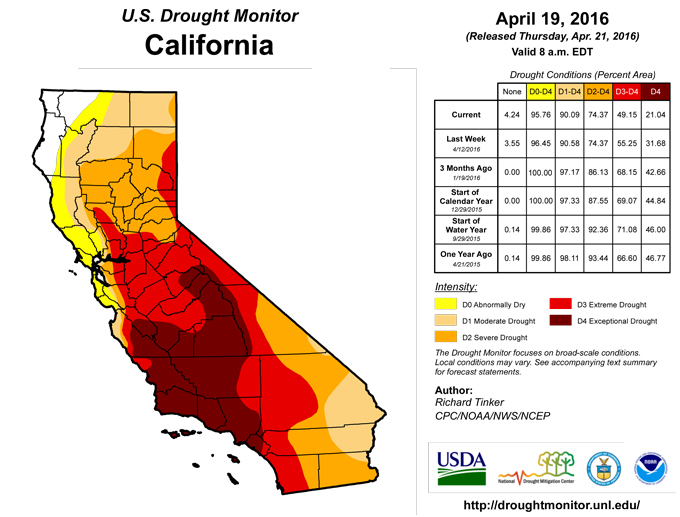
Little or no precipitation fell on the areas of dryness and drought in the Far West from the southeastern fringes of Washington southward through Oregon, California, and Nevada, but with the wet season winding down (especially in California), its impact on the long-term drought situation and the conditions being set up for the summer dry season are coming into better focus. Based on improved reservoir levels (and potentially water supplies), streamflows, and to a lesser extent groundwater levels, additional improvement was introduced in the Drought Monitor, most notably in some parts of California most intensely impacted by the drought for the past few years. In a nutshell, the northward and northeastward extents of both the extreme (D3) and exceptional (D4) drought areas was reduced, including the removal of all D4 from southwestern Nevada. This is the first week since early July 2013 with no exceptional drought in the state of Nevada.Hawaii, Puerto Rico, and Alaska
Heavy rains in windward parts of the Hawaiian Islands reduced the extent of abnormal dryness there, but drought coverage (D1 to D4) declined only slightly on small parts of Kauai and the Big Island. Drought impacts on agriculture in part of the Big Island continue to increase, leading to some expansion of D3 in the Island’s southwestern reaches. Dryness and drought were unchanged in Puerto Rico and Alaska. Most affected areas recorded light precipitation. Moderate amounts (one to a few inches) fell on parts of central Puerto Rico and the Alaskan Panhandle, but amounts were not sufficient to bring significant improvement (particularly in the latter region, where normal are large).Looking Ahead
During April 21 -25, 2016, moderate precipitation totals of 0.5 to 2.0 inches with locally higher amounts are forecast for northern California, much of the Sierra Nevada, the northern tier of the Rockies and Plains, central and eastern Texas, and the central Appalachians. A few tenths of an inch at best are expected in other affected areas across the contiguous 48 states. Temperatures should average a few degrees above normal across much of the Intermountain West, Rockies, and Plains.The odds favor above-normal precipitation across most of the contiguous 48 states and southern Alaska during April 26 – 30, 2016. There are enhanced chances for subnormal precipitation in the D0 areas in southeastern Georgia and northeastern Florida, and no tilt of the odds towards either wetness or dryness in central South Carolina and in the Big Bend region of Texas and adjacent New Mexico. Enhanced chances for warmer than normal conditions exist from the southern half of the Plains eastward to the central Appalachians and the Southeast Coast and across Alaska, but cooler than normal weather is favored in most of the Far West, the northern Plains, and the Northeast.
Author(s):
Richard Tinker, NOAA/NWS/NCEP/CPC
Dryness Categories
D0 ... Abnormally Dry ... used for areas showing dryness but not yet in drought, or for areas recovering from drought.Drought Intensity Categories
D1 ... Moderate DroughtD2 ... Severe Drought
D3 ... Extreme Drought
D4 ... Exceptional Drought
Drought or Dryness Types
S ... Short-Term, typically <6 months (e.g. agricultural, grasslands)L ... Long-Term, typically >6 months (e.g. hydrology, ecology)
Source: National Drought Mitigation Center
