


California and National Drought Summary for February 3, 2026
Summary
February 5, 2026 - There was a strong west-to-east temperature gradient this week, with temperatures below normal in the East, particularly in the Midwest and Northeast, and above normal in the West. Precipitation was scarce across large portions of the nation, with many areas receiving less than 25% of normal precipitation. Areas of localized precipitation fell across the Pacific Northwest, northern Rockies and the Great Lakes region. Out east, a winter storm brought snow and mixed precipitation to parts of the Tennessee Valley and the Carolinas, with locally heavy snowfall in some locations.
Across the West, snowpack remains well below the seasonal average. Even in areas that received snow, low snowpack combined with dry soils and low streamflows led to degradations across the Intermountain West. Along the West Coast, precipitation remained limited and uneven. Western Oregon saw dry and drought conditions expand toward the Pacific coast and into far south Washington and northwest California.
Elsewhere, scattered degradations occurred across the South and Southeast, where another week without precipitation added to growing precipitation deficits, except for localized areas of improvement that continued to benefit from last week’s heavy snowfall. Other isolated areas of improvement were seen in southern New Mexico and in the Midwest and Northeast.
Northeast
Cold temperatures and limited frozen precipitation led to persistent conditions across the Northeast, outside of areas of localized improvements to New York. Except for areas of lake-effect snow, the Northeast received little precipitation. In New York, longer-term indicators supported several targeted improvements where precipitation deficits and groundwater conditions showed gradual recovery. Elsewhere across the Northeast, conditions remained unchanged, though streamflows across much of the region remain below normal and soil moisture indicators are showing dry conditions at deeper layers.
Southeast
Precipitation patterns generally drove drought changes across the Southeast this week. While some areas continued to benefit from moisture that fell earlier in the winter, much of the region experienced a mostly dry and cold week. A winter storm this week did bring well-above-normal precipitation to the coastal Carolinas, much of it falling as snow. The combination of frozen precipitation and cooler temperatures limited the immediate hydrologic benefits, leaving the area unchanged.
Across the central Gulf Coast region, extending from southern Mississippi through southern Georgia and into northern Florida, conditions continued to deteriorate following another week without precipitation. A growing precipitation deficit, very low streamflows, declining soil moisture and increasing fire danger led to degradation across parts the region. Extreme drought (D3) from southern Georgia into northern Florida broadly expanded farther south across the Florida Peninsula, precipitation deficits continued to grow after missing out on meaningful precipitation. This led to one-category degradations across the central peninsula, with the introduction of severe drought conditions (D3) southeast of Tampa Bay. The southern Everglades area saw the introduction of severe drought (D3) due to extremely low groundwater levels, minimal surface water availability and elevated fire danger. Virginia remained unchanged outside of one-class degradations in the southeast, where recent precipitation was insufficient to offset longer-term deficits.
South
Drought conditions across the South generally continued to worsen this week, as much of the region received little to no precipitation. Temperatures were near to slightly above normal across large portions of the region. Outside of a few localized improvements in northeast Louisiana and southeast Mississippi from last week’s winter storm, conditions continued to degrade across most of the region. Across the southern Plains into the Lower Mississippi Valley, one-category degradations were seen across parts of Texas, Oklahoma, Arkansas, Louisiana and southwest Mississippi after another dry week with no meaningful precipitation. Short- to mid-term precipitation deficits continue to grow and soil moisture continues to decline, along with streamflows.
Midwest
Cold temperatures and limited frozen precipitation led to persistent conditions across the Midwest, outside of areas of localized changes. Cold conditions kept soils frozen across northern portions of the Midwest, limiting infiltration and preventing recent moisture or snowmelt from entering the hydrologic system. As a result, short-term improvements to soil moisture and streamflows were minimal. Western Michigan saw a localized improvement where another week of snowfall along the Lake Michigan shoreline, combined with improving longer-term precipitation indicators, supported modest recovery. Across parts of the western and central Midwest, minor degradations were introduced as conditions continued to dry, including the introduction of extreme drought (D3) in southwest Missouri along the Missouri-Oklahoma border. In these areas, precipitation during the past several weeks has been limited, and short- and mid-term precipitation deficits continued to grow, combined with declining soil moisture and below-normal streamflows.
High Plains
Conditions across the central and northern High Plains were mostly unchanged this week, as most of the region received little to no meaningful precipitation. Cold temperatures persisted, and where snow did fall, it remained largely frozen in place, limiting short-term benefits to soils or hydrologic conditions. Conditions across the Wyoming and Colorado Plains continued to deteriorate. Snow water equivalent (SWE) remains well below average, with SNOTEL data showing values generally in the 50 to 70 percent of median range, reflecting how snowpack continues to fall short for this time of year despite recent snowfall. Severe drought (D2) expanded from southeastern Wyoming into northeastern Colorado and a little into the Nebraska Panhandle. Abnormal dryness (D0) and moderate drought (D2) also expanded across portions of Kansas.
West
Across much of the West, conditions worsened, driven by a deepening snow drought, limited precipitation, and above-normal temperatures that continued to undermine snowpack development. While some mountain snowfall occurred, amounts were generally modest and failed to keep pace with early February climatological accumulation rates, causing snowpack deficits to expand across much of the region.
The Intermountain West saw conditions intensified as snow accumulation continues to fall well short of what is expected this time of the year. Numerous SNOTEL sites reported SWE below the 15th percentile, with several stations registering the lowest SWE on record for early February. These snowpack deficits were compounded by limited recent precipitation, declining soil moisture, and below-normal streamflows, particularly across northern Idaho and western Montana and extending into central and southern Montana and Wyoming. Similarly, Colorado and Utah saw conditions deteriorate as SWE levels are well below the median level along with drier soil moisture.
Across southwestern Idaho, northern Nevada and into eastern Oregon, persistent warmth, scarce precipitation, poor low-elevation snowpack, and low streamflows led to the expansion of abnormally dry (D0) and moderate drought (D1) conditions as well as the introduction of moderate drought (D2) along the Idaho-Wyoming border. SNOTEL stations in the Owyhee, Independence and Snake Mountains are reporting SWE levels between the ninth percentile to the worst on record.
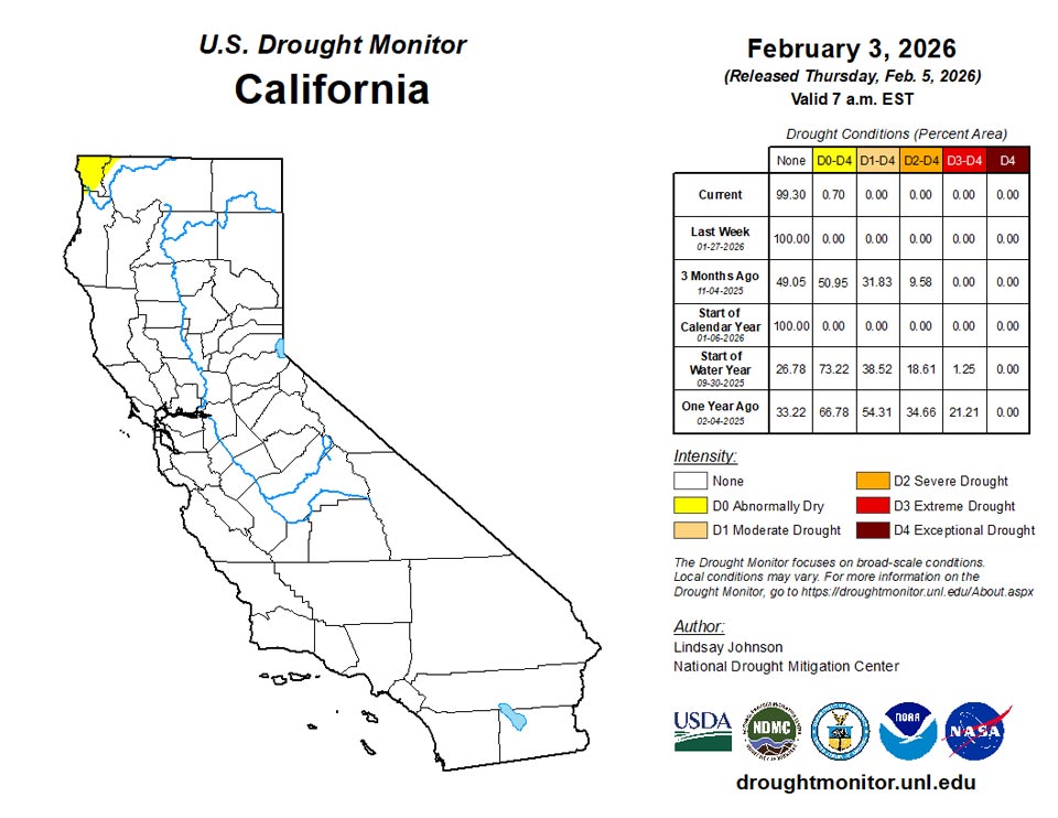
Along the Pacific Coast, centered over Oregon, abnormally dry (D0) conditions expanded into southern Washington and northwestern California as the mid-winter dry spell continues, with poor snowpack development, very low streamflows, and limited soil moisture recovery outside the highest elevations (SNOTEL SWE percentile map; state precipitation and streamflow maps).
The only improvement across the West occurred in southern New Mexico, where precipitation from earlier storm systems continued to translate into measurable hydrologic response, supporting localized improvements and one-category improvements.
Caribbean
Abnormally dry conditions across Puerto Rico improved across the northern portion of the island, following heavy rainfall from a passing cold front. Rainfall was most impactful across northwestern and northeastern portions of the island, where streams ran high and rainfall deficits were erased or reduced, supporting the removal of D0 in those areas. Temperatures were near to slightly above normal.
Elsewhere across the island, conditions were held steady. In the interior, water supply concerns persist near Cidra, where Lago Cidra remains at observational levels. Across southeastern Puerto Rico, USGS-monitored wells near Salinas and Santa Isabel continue to run low, supporting no change in drought depiction for those areas.
Wet weather struck western parts of St. Croix this week, where CoCoRaHs observations suggested widespread rainfall amounts over 2 inches. In the east, this week’s weather was drier, and depth-to-water at the well monitoring site continued to drop slightly. Short-term abnormal dryness was maintained this week, though this mostly describes conditions in the east, as conditions have likely improved in western St. Croix after this week’s heavier rains. On St. John, conditions improved to short-term abnormal dryness after rainfall observations of 1.5 and 2.32 inches were reported and well depth-to-water rose slightly. Short-term moderate drought continued on St. Thomas, where rainfall observations ranged from 0.74-0.84 inches.
Pacific
Conditions worsened across parts of western Alaska this week. Temperatures were near to above normal, and while some snowfall did occur, amounts were light and uneven, providing little benefit and causing SWE to remain well below normal across affected areas.
In addition, a small area of moderate drought (D1) was introduced east of Kotzebue, where SWE was modeled at less than half of the 1991–2020 median. Elsewhere across the state, conditions were largely unchanged, though snowpack deficits continue to be monitored as the winter season progresses.
Drought conditions across Hawaii were unchanged this week. Temperatures were near to slightly above normal, and a frontal system brought light to locally moderate rainfall, generally around 0.5 to 1 inch, with the highest amounts confined to windward-facing terrain. Despite the rainfall, streamflows showed little response.
Rainfall amounts this week on Palau ranged from 1.58 inches at the National Weather Service office to 2.07 inches at Koror. While the weather has been generally drier recently, conditions are not yet in the abnormal dryness category.
At Toa Ridge, 7.37 inches of rain were reported this week, and at least 11 inches of rain fell in Pago Pago. Given the very wet weather this week, conditions remained normal in American Samoa.
The Mariana Islands remained free of drought or abnormal dryness this week. Saipan received 3.49 inches of rain this week, continuing a recent wet stretch that resulted in record wetness in January after almost 10 inches of rain fell last week. In Tinian, 1.14 inches of rain were reported this week. Rota received 7.07 inches of rain this week. Guam received 2.17 inches at the National Weather Service office, while a CoCoRaHs observer near Piti (on the west coast) reported 1.88 inches of rain.
In Yap, 1.68 inches of rain fell this week, marking the third consecutive week with less than 2 inches of rain. However, given that January as a whole was wetter than normal, conditions have not yet fallen into abnormal dryness. In Woleai, 0.46 inches of rain were reported, though 3 days were missing from this week’s data. Three of the previous four weeks also had over 2 inches of rainfall, so conditions remained normal. In Chuuk, 1.41 inches of rain fell this week, marking the second week in a row with under 2 inches of rain. The previous 2 weeks were much wetter, though, so conditions remained normal. In Lukunor, 0.94 inches of rain fell this week, continuing a recent mainly drier pattern. However, given that over 4 inches of rain fell a couple weeks ago, conditions have not yet slipped into abnormal dryness. In Nukuoro, 1.78 inches of rain fell, marking a second week of below 2 inches of rain. However, over 6 inches of rain fell a couple weeks ago, so conditions remained normal. Conditions in Kapingamarangi slipped to short-term abnormal dryness, where just 0.31 inches of rain this week continued a stretch when six of the last seven weeks have totaled less than 2 inches of rain. In Pohnpei, 5.38 inches of rain fell this week, and conditions remained normal. In Pingelap, short-term moderate drought continued after 0.8 inches of rain fell this week. Conditions in Kosrae remained normal, where 7.85 inches of rain fell this week. No Drought Monitor depictions were made in Ulithi or Fananu, as no data were available for either location.
In Kwajalein, 0.24 inches of rain were reported this week, marking the third consecutive week with less than 2 inches of rain. Given that over 7 inches of rain fell the week prior to this stretch, conditions are not quite at abnormal dryness, but the recent dry pattern will continue to be monitored. In Ailinglaplap, 1.61 inches of rain were reported, marking a second week in a row with less than 2 inches of rain, continuing a mostly dry pattern. Almost 4 inches of rain fell a couple weeks ago, so conditions are not quite abnormally dry, but the recent dryness will continue to be monitored. Conditions remained normal in Jaluit, where 3.03 inches of rain fell. Short-term moderate drought continued in Utirik and Wotje. The first few days of February in Utirik saw just 0.04 inches of rain, while Wotje has received 1.12 inches. Only 0.92 inches of rain fell in Majuro this week, marking two weeks in a row with less than 2 inches of rainfall. However, conditions there remain normal given a wetter pattern before the last two weeks. Mili has received 0.32 inches of rain so far in February, and conditions remained normal there.
Looking Ahead
Over the next five to seven days, an active weather pattern is expected across much of the continental U.S., with several regions showing a strong signal for precipitation. The heaviest precipitation is forecast from the lower Mississippi Valley northeastward into the Ohio and Tennessee valleys, where widespread totals of 1 to 3 inches are expected, with locally higher amounts possible. Portions of the central Plains, Midwest, and Great Lakes are anticipated to receive generally 0.5 to 1.5 inches of precipitation during this period. Across the West, precipitation is expected to be widespread from the Pacific Northwest into the northern and central Rockies. Liquid-equivalent totals of 1 to 3 inches are forecast in the Cascades and northern Rockies, with locally higher amounts possible at higher elevations. Farther south into the Great Basin and Southwest, precipitation becomes more scattered, with most areas receiving less than 0.5 inches, and many locations remaining dry. Drier conditions are expected to persist across California, the northern Great Plains, central and southern Texas, and much of the Florida Peninsula, where little to no precipitation is forecast over the next week.
The Climate Prediction Center’s 6–10 day temperature outlook (Feb. 10-14) shows a strong and widespread signal for above-normal temperatures across much of the continental U.S. The highest probabilities of above-normal temperatures are centered over the central and southern Plains, extending northward into the northern Plains and Upper Midwest. Much of the Intermountain West, Rockies, and interior West also favors above-normal temperatures. Along the West Coast, temperatures are expected to be near normal, while parts of the Northeast show a transition from below normal in northern New England to near or above normal farther south. Portions of the Southeast, including Florida, are favored to see near-normal temperatures. Alaska shows a mix of near- to below-normal temperatures across the mainland, with near-normal conditions favored over the southern coast. Hawaii is favored to experience above-normal temperatures during this period.
The Climate Prediction Center’s 6–10 day precipitation outlook (Feb. 10–14) favors above-normal precipitation across much of the western U.S., including the Southwest and West Coast, with elevated probabilities extending into parts of the northern Rockies. Above-normal precipitation is also favored across Alaska and Hawaii during this period. In contrast, below-normal precipitation is favored across Florida and portions of the far Southeast, while much of the central U.S. is expected to see near-normal precipitation.
Author(s):
Lindsay Johnson, National Drought Mitigation Center
Curtis Riganti, National Drought Mitigation Center
Dryness Categories
D0 Abnormally Dry—used for areas showing dryness but not yet in drought, or for areas recovering from drought.
Drought Intensity Categories
D1 Moderate Drought
D2 Severe Drought
D3 Extreme Drought
D4 Exceptional Drought
Drought or Dryness Types
S Short-term, typically less than 6 months (agriculture, grasslands)
L Long-term, typically more than 6 months (hydrology, ecology)
SL Area contains both short- and long-term impacts

Source: National Drought Mitigation Center
