


California and National Drought Summary for February 17, 2026
Summary
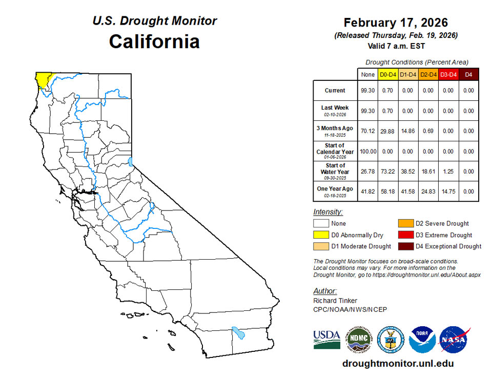
February 19, 2026 - After a few warm and dry weeks, heavy precipitation returned to the West Coast States this past week; however, the heaviest amounts fell on California, which is almost completely free of dryness and drought. At least 1.5 inches fell on a large part of the state including much of the western tier, the higher elevations, and the northern Valleys. Much larger amounts fell on isolated higher-elevation and orographically-favored locations, with a few spots recording amounts approaching 10 inches (liquid-equivalent). Several feet of snow has piled up on a few spots across the Sierra Nevada, but overall the snowpack in this area remains significantly below normal. Other areas from northwestern California northward through the Cascades and points west also recorded significant amounts of precipitation, ranging from 0.5 to locally 3.0 inches. Similar amounts were more scattered across the rest of the interior West, with the largest totals confined to the highest elevations. As of early Tuesday Feb 17, this precipitation has not significantly boosted snowpack in some areas with less than normal amounts, specifically much of the Cascades, south-central Idaho, Scattered locations across western Wyoming, much of west-central and southwestern Colorado, central sections of Utah and Nevada, and the southernmost Rockies.
Farther east, moderate precipitation was fairly widespread over approximately the southeastern quarter of the contiguous states, east of the High Plains and from the central Great Plains, lower Ohio Valley, and mid-Atlantic region southward. Heavier amounts fell on scattered areas across the east-central and southeastern Great Plains, parts of the adjacent lower Mississippi Valley, and a few narrow swaths across the western Florida Panhandle and parts of the northern Peninsula. To the north, scattered light amounts with isolated moderate totals were recorded in upstate New York and parts of New England. Other areas across the High Plains and the northeastern quarter of the contiguous states reported little or no precipitation.
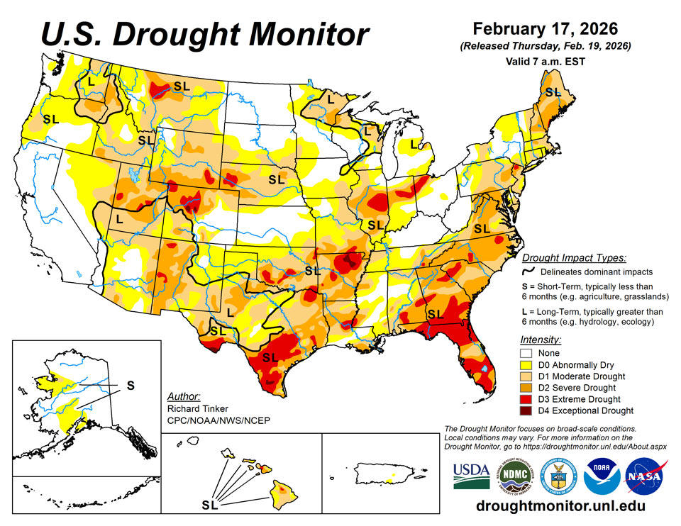
Some areas of improvement were introduced based either on this past week’s precipitation or a re-assessment of the effects from earlier storms. Specifically, improvements were introduced in central Idaho, the southwestern High Plains, and parts of the Tennessee, lower Ohio, and middle Mississippi Valleys. There was more deterioration than improvement overall, however, including areas scattered across the Eastern Seaboard, lower Mississippi Valley, Deep South, Upper Midwest, northern High Plains, and far southern Texas. Hawaii experienced areas of improvement for the second consecutive week while Alaska and most dry areas in Puerto Rico remained unchanged.
Northeast
Pennsylvania, southern New England, and northwestern Maine recorded very little precipitation while light to isolated moderate amounts (up to an inch) dampened upstate New York, northern New England, and eastern Maine. On the southern end of the region, moderate amounts fell on West Virginia and Maryland, with widespread totals of 0.25 to 0.75 inch. The precipitation was insufficient to justify any areas of improvement, so drought in the Northeast Region generally remained the same with a few areas of deterioration, particularly in central and eastern Pennsylvania, adjacent New Jersey, and southern New England. This includes the introduction of an area of extreme drought (D3) in northern New Jersey. Precipitation totaled over the last 60 and 90 days is under half of normal in a large swaths from the Maryland Panhandle through southern and into east-central Pennsylvania, along with scattered areas across New England and southern New York.
Southeast
Compared to the Northeast, light to moderate precipitation was far more widespread, especially from southern Virginia through the central Carolinas, much of Georgia, and northern Florida, where many locations reported over 0.5 inch. A few areas of in the central Carolinas and isolated patches in the southern Appalachians, central Georgia, and the northern half of Florida reported 1.5 to 2.0 inches, but given recent deficits, none of these areas received enough to substantially change the intensity of extant dryness and drought. In drier areas – especially the southern half of the Florida Peninsula – dryness and drought expanded and intensified. One-category deterioration was brought into the southern Appalachians and adjacent foothills, parts of the eastern Carolinas, central Georgia, and several patches across Florida. This has resulted in several large swaths of extreme drought (D3) from western South Carolina southward, with the largest areas extending from southern Georgia into central Florida, and across the southern Florida Peninsula. During the last 3 months, precipitation totals were 6 to 12 inches less than normal over southwestern North Carolina and adjacent areas, with 4 to 8 inch deficits common across northern Georgia and much of the rest of the western Carolinas. Farther south, scattered locations across the southern half of the Florida Peninsula reported less than one-quarter of normal amounts for the last 90 days.
South
Heavy precipitation (3 to locally 5 inches) dropped on a swath through central Arkansas while 1.5 to locally 3.0 inches were recorded from the lower Red River (south) Valley through the central tier of Arkansas into much of western Tennessee. Moderate to locally heavy amounts were observed over much of the west side of the lower Mississippi Valley and portions of eastern Texas. Amounts of several tenths of an inch to locally around an inch were reported across a large part of central and north-central Texas, most of Oklahoma east of the Panhandle, much of Mississippi and western Alabama, and eastern sections of Tennessee. Little or no precipitation was reported across the Texas and Oklahoma Panhandles, western Texas, and Deep South Texas. This pattern supported improvement across the western half of Tennessee and smaller areas of Arkansas and northwestern Mississippi, along with scattered spots across southern Oklahoma. Deterioration was fairly common in areas that missed most of the week’s precipitation, primarily in the lower Mississippi Valley, the immediate ArkLaTex region, and Deep South Texas. Intensifying dryness in the latter area prompted the introduction of exceptional drought (D4) in parts of Jim Hogg and Brooks Counties. D4 already existed in part of interior northeastern Arkansas and the southernmost reaches of the Texas Big Bend. Meanwhile, extreme drought (D3) expanded to cover most of south-central and Deep South Texas, parts of east-central Louisiana and adjacent Mississippi, portions of southern Oklahoma and northeastern Texas, most of northeastern Arkansas, and a few smaller scattered areas in western Arkansas and northeastern Oklahoma. During the past 90 days, fewer than 2 inches of precipitation have fallen on western Oklahoma, the Texas Panhandle, and the southwestern tier of Texas from the Big Bend into much of Deep South Texas.
Midwest
Central and northern portions of the Midwest were almost precipitation-free last week, prompting some deterioration across the Upper Midwest from northern Illinois across Iowa into southern Minnesota. Farther south, light to moderate amounts (up to an inch) fell on the middle and lower Ohio Valley and the adjacent Mississippi Valley, with heavier totals (1.5 to locally 3.0 inches) reported across central and southern Missouri. This pattern led to improvements in a swath from central and southern Missouri through southern Illinois and western Kentucky.
High Plains
Moderate to locally heavy precipitation fell on part of eastern Kansas, and scattered light to moderate amounts fell on the rest of the southern tier of the Region. Farther north, however, scant precipitation led to large areas of degradation across a large proportion of Wyoming and central through eastern Montana, with more limited deterioration introduced across parts of Nebraska and South Dakota. This resulted in moderate drought or worse covering a swath across most of Nebraska and adjacent areas westward through most of Wyoming and the northern, central, and western sections of Colorado. Severe drought (D2) or worse is widespread from western Nebraska across the southern tier of Wyoming through northern and central parts of Colorado.
West
Heavy precipitation was fairly widespread across California, which is currently almost completely devoid of any degree of dryness or drought. Elsewhere, widespread deterioration was introduced across central and eastern Montana, leaving most of the state entrenched in abnormal dryness to severe drought (D0 to D2), with an area of extreme drought in parts of north-central Montana. Elsewhere, only minor adjustments were made as light to moderate precipitation fell on a large part of the areas of dryness and drought – enough to preclude widespread deterioration, but not sufficient to justify much improvement. Only a few parts of central and south-central New Mexico were improved, primarily from the effects of precipitation prior to last week. Severe to extree drought (D2-D3) now extends across most of the western half of New Mexico, adjacent4 Arizona, central and northern Utah, parts of northern and southwestern Idaho, and parts of Pacific Northwest east of the Cascades.
Caribbean
Moderate to locally heavy rainfall fell on relatively large patches across the state, but only the eastern tier of the interior D0 area recorded enough precipitation to end D0 conditions. Most D0 areas were unchanged from last week.
After a wet week, conditions dried out across the U.S. Virgin Islands, with all islands reporting below-normal weekly precipitation totals. On St. John, Rafe Boulon/Windswept Beach reported 0.59 inches of rain. Despite the lower total, St. John remains free of drought and abnormal dryness. Groundwater levels at the Susannaberg DPW 3 well were 11.97 ft below land surface on February 17. Analysis shows a steady decline since October 19, when the level was 7.56 ft, though there has been a slight recovery this month compared to the 12.97 ft reported on February 2. Over the past year, the water level has dropped approximately 4.5 ft (from 7.46 ft on February 17, 2025). Nearly all SPI timescales indicate wet conditions—especially the 1-month value—though the 6-month SPI showed some dryness. No measurable precipitation was reported on St. Croix (Henry Rohlsen Airport) this week, but the island remains free of drought and abnormal dryness due to above-normal rainfall in previous weeks. The depth to water at the Adventure 28 Well was 19.72 ft below land surface on February 17. Groundwater analysis shows a steady decrease of 5.8 ft since May 27, 2025 (when the level was 13.91 ft), and a drop of 3.3 ft compared to this time last year (16.39 ft on February 17, 2025). The 1-, 3-, and 6-month SPI values confirm wet conditions on the island, while longer timescales show drier signals. On St. Thomas, Cyril E. King Airport reported a rainfall total of 0.73 inches. The depth to water at the Grade School 3 well was 6.24 ft below land surface on February 17. This is down 4.19 ft from the 365-day maximum of 2.05 ft recorded on October 19, 2025. However, it is only 0.66 ft lower than the water level from one year ago (5.58 ft on February 17, 2025). SPI values were mixed, showing wetter conditions at the 1-month timescale but dry conditions at the 3-month timescale (other timescales were unavailable). Consequently, St. Thomas remains in short-term abnormal dryness (D0-S) this week.
Pacific
Conditions across Alaska were unchanged this week, with small areas of moderate drought noted in part of west-central and interior southwestern Alaska while D0 covered considerably larger areas from the lower northwestern part of the state through south-central locations, including part of the Anchorage area.
Precipitation amounts exceeded 3 inches at a few locations across Oahu and some of the windward and higher elevations elsewhere. Other locations recorded near or somewhat below normal amounts, but the excessive precipitation that affected numerous locations the prior week prompted additional improvements over portions of the state. Specifically, additional1-category improvements were introduced along much of the northeastern tier of the Big Island, northeastern and western areas of Maui, and smaller patches of central Maui, eastern Molokai, and southern Oahu. This included the removal of any dryness or drought designation in small patches across northeastern sections of both Maui and the Big Island, marking the first time since late March that any part of Maui has emerged from dryness, and the first time since late August in the Big Island.
Conditions were dry over American Samoa this week. Pago Pago reported a weekly rainfall total of 0.40 inches, while Toa Ridge and Siufaga Ridge reported 0.26 and 0.37 inches, respectively, with several days missing from the records.
Palau remained free of drought or abnormal dryness this week. The Koror COOP site reported a weekly rainfall total of 2.10 inches (with two days missing) and a month-to-date total of 6.30 inches as of February 15.
Conditions were drier than normal over the Mariana Islands this week. Rota, Guam, Tinian, and Saipan reported weekly rainfall totals of 0.87, 0.59, 0.42, and 0.09 inches, respectively. Although these amounts were below the island’s one-inch minimum threshold to meet water needs, the Marianas remained free of drought and abnormal dryness due to wet conditions in previous weeks.
Conditions were mixed across the Federated States of Micronesia this week. Nukuoro and Pohnpei reported weekly rainfall amounts of 5.24 inches and 2.35 inches, respectively, and both locations remained free of drought and abnormal dryness. Several locations, including Chuuk (1.15 inches), Woleai (1.09 inches), Kosrae (1.04 inches), and Lukunoch (0.51 inches), reported rainfall totals (each with 1 day missing) below the two-inch minimum threshold needed for water needs; however, these locations remained free of drought and abnormal dryness due to previously wet conditions. Kapingamarangi reported 2.80 inches this week but remained in short-term abnormal dryness (D0-S) due to precipitation deficits from previous dry weeks. Pingelap reported only 0.02 inches of rainfall and remains in short-term moderate drought (D1-S). Data for Fananu and Ulithi were insufficient to make any assessments this week.
Dry conditions prevailed across most of the Republic of the Marshall Islands this week, as all islands reported weekly rainfall totals below the minimum two-inch threshold for water needs. Despite the low totals (and with some locations missing a day of data), Jaluit (1.19 inches), Ailinglapalap (0.54 inches), Kwajalein (0.28 inches), Mili (0.16 inches), and Majuro (no reported rainfall) remained free of drought and abnormal dryness due to above-normal precipitation received in previous weeks. Based on recent precipitation and rainfall totals from previous weeks and months, Utirik reported 1.18 inches this week and remained in short-term severe drought (D2-S). Meanwhile, conditions continued to deteriorate over Wotje, which reported only 0.12 inches for the week and a month-to-date rainfall total of 1.34 inches. For these reasons, Wotje was degraded to short-term severe drought (D2-S) this week.
Looking Ahead
The heaviest precipitation over the next few days is forecast along and near part of the West Coast, with at least 2 inches expected across northwestern California, the southern Cascades, and the central and northern Sierra Nevada. Up to 7 inches may fall in isolated higher elevations, most or all of which would be snow. Meanwhile, moderate to heavy amounts (0.5 to 2.0 inches) are forecast across Washington and Oregon from the Cascades westward. Similar amounts are forecast for the northern Great Lakes, and most locations from the Deep South through central New England, with lesser amounts expected over much of the central and northern Carolinas. There is a lot of uncertainty in this area, depending on the development and track of an East Coast storm system that could affect the mid-Atlantic and lower Northeast over the weekend. Light to moderate totals are anticipated over a large part of the interior West, including the Great Basin, much of the northern Intermountain West, and the higher elevations across the Rockies. Several tenths of an inch are possible across the lower Great Lakes, middle and lower Ohio Valley, and the east side of the lower Mississippi Valley. Little or no precipitation is expected across the northern and southern Plains, southern Florida, and northern Maine. Above-normal temperatures are expected from the Southwest through most of the Plains, with many locations expected to average 5 to 11 deg. F above normal. In contrast, subnormal temperatures are forecast in the northernmost Plains, where daily highs could average as much as 9 deg. F below normal. Meanwhile, 5-day average anomalies are expected to range from -2 to -5 deg. F across northern California as well as the Ohio Valley and many locations farther east.
The 6- to 10-day outlook for February 24-28 depicts increased chances for below-normal precipitation across much of the southern tier of the contiguous U.S., from the extreme southern Rockies through the central Gulf Coast and most of Florida. Chances for abnormal dryness exceed 40 percent across most of Texas and some adjacent areas. Farther north, heavier than normal precipitation is at least nominally favored from the mid-Atlantic, southern Appalachians, central Plains, and Desert Southwest northward to the Canadian border. Chances for unusually unsettled weather exceed 60 percent across central and northern California, and top 50 percent central California northward across western Washington and Oregon, as well as the middle and lower Ohio Valley. In Alaska, drier than normal conditions are favored along western parts of the state while surplus amounts are more likely over eastern areas. Across Hawaii, above-normal amounts are marginally favored statewide. Meanwhile, warmer than normal weather is expected to dominate the contiguous 48 states from the Appalachians to the Intermountain West, with chances for significantly warmer than normal conditions topping 80 percent in western Texas. Areas somewhat favoring below-normal temperatures are restricted to the West Coast west of the Cascades, and over much of the Florida Peninsula. Considerably higher chances for unusually cold weather cover most of Alaska, reaching above 70 percent in southwestern parts of the state. In contrast, warmer than normal conditions are somewhat favored across Hawaii, especially across Kauai, Oahu, and the southern Big Island.
Author(s):
Richard Tinker, NOAA/NWS/NCEP/CPC
Rocky Bilotta, NOAA/NCEI
Dryness Categories
D0 Abnormally Dry—used for areas showing dryness but not yet in drought, or for areas recovering from drought.
Drought Intensity Categories
D1 Moderate Drought
D2 Severe Drought
D3 Extreme Drought
D4 Exceptional Drought
Drought or Dryness Types
S Short-term, typically less than 6 months (agriculture, grasslands)
L Long-term, typically more than 6 months (hydrology, ecology)
SL Area contains both short- and long-term impacts
Source: National Drought Mitigation Center
