


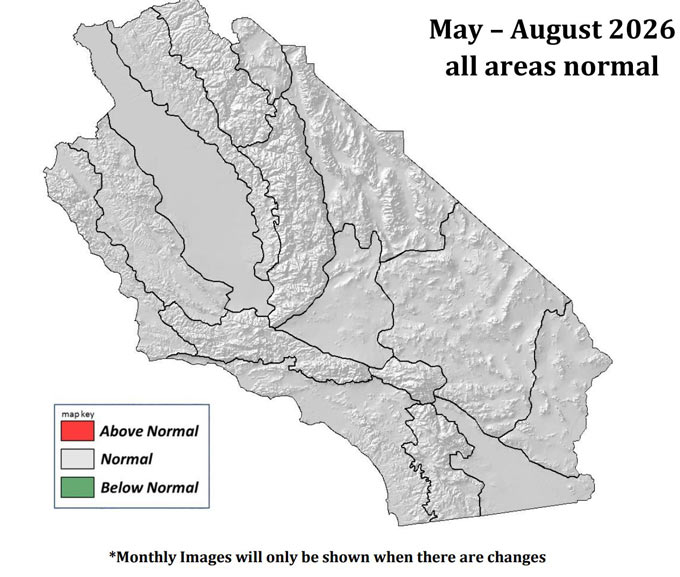
May – August 2026 South Ops Highlights
• Temperatures will likely be above normal through August, and the marine layer will be shallower than normal.
• The monsoon will likely begin a little later than normal, but once it starts, near to above normal shower and thunderstorm activity is likely.
• In addition to traditional monsoonal activity, there is a well above normal likelihood for remnant tropical cyclone impacts on Southern California starting in July.
April 30, 2026 - After March saw historic heat over the West, a far more seasonable pattern prevailed in April with temperatures this month running
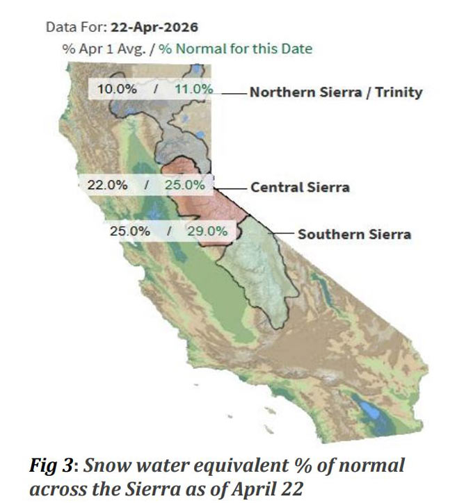
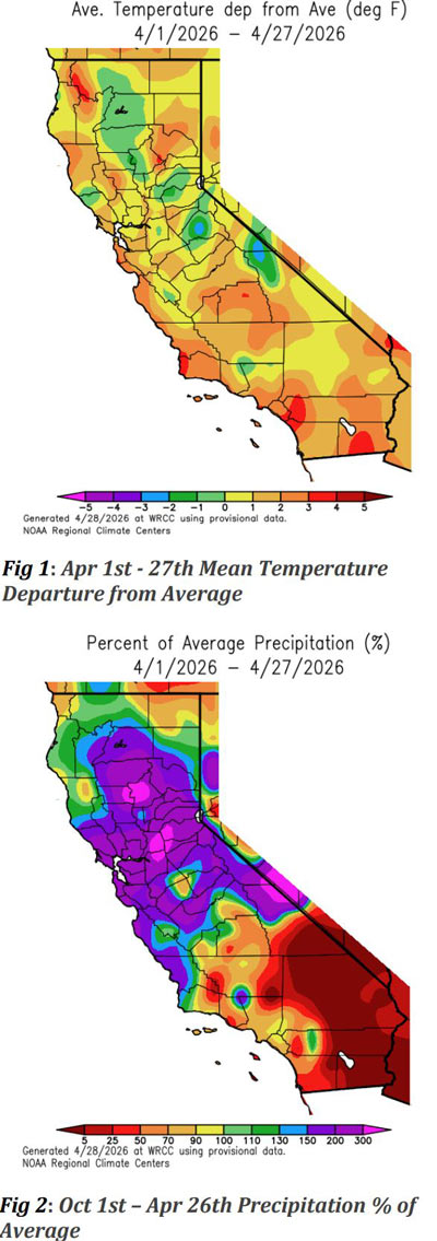 near to only slightly above normal (Figure 1). It was a wet month as well, as despite the climatological dry season nearing its end, multiple rounds of wetting rains soaked the region. Central California in particular saw well above normal rainfall, while Southern California was closer to average, and desert areas remained drier (Figure 2). In terms of snow, the storms in April did bring some meaningful snowfall to the higher elevations of the Sierra. However, this came after a near total wipeout of the snowpack in March, and one of the lowest April 1 snowpack readings ever recorded. As of late April, the snowpack for the Central and Southern Sierra was running about 25-30% of normal (Figure 3), which actually represents some improvement from earlier in the month.
 There was a mixture of both offshore and onshore flow in April, which generally corresponded to the alternating warmer and cooler periods, respectively. A moderate Santa Ana wind event occurred early in the month, with the wind-driven Springs Fire burning over 4,000 acres in Riverside County during that event.
Fuels Discussion
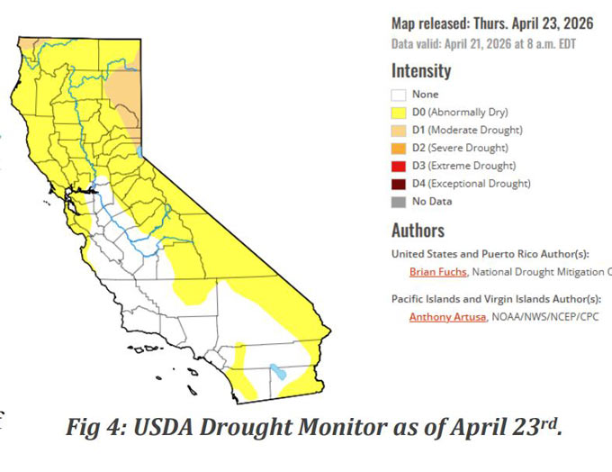
Latest USDA Drought Monitor (Figure 4) shows that there are no drought conditions present over Central and Southern California, though abnormally dry conditions do exist in some areas mainly as a result of the extremely hot and dry March. The recent and ongoing damp pattern should ensure no further degradations in drought status, and may yield improvements.
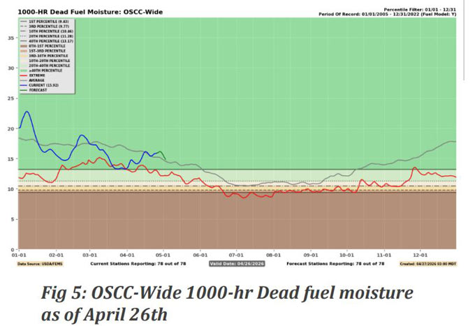
Dead fuel moisture values generally trended near normal in April, with periodic rains yielding recoveries in fuel moisture after record dryness in March. (Figure 5)
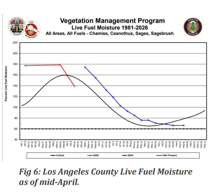
While April conditions were seasonable and supportive of grass growth, there was more in the way of grass curing than new growth in April simply because the curing process had already been initiated in March. It is distinctly possible that new grass growth will occur in May due to lingering moisture from April and a continued supportive growing pattern. Brush live fuel moistures are highly varied. Some areas are just coming out of dormancy and seeing rapid LFM increases. Conversely, some areas saw much earlier than normal LFM peaks due to the unusual March conditions and are already into drying trends well ahead of schedule (Figure 6). However, the ongoing pattern will stem these trends and may promote some further growth.
SOUTH OPS OUTLOOK
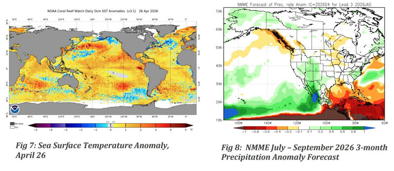
Current SST anomalies in the tropical Pacific show rapidly evolving conditions (Figure 7). The weak La Nina event from early this past winter has long since passed. After just a brief period in neutral conditions, the current pattern looks decidedly more like an El Nino state. There are strong indications from observational data and climate models that El Nino development is well underway. The latest projections suggest the likelihood of a strong El Nino developing in the coming months. Also of significant note are very warm SST anomalies extending from the California coast and southward. This is expected to reduce marine layer depth this spring. The shallower marine layer combined with the likelihood of a strong subtropical ridge this summer is expected to promote predominantly above normal temperatures through the summer months. Model projections are also now favoring above normal precipitation during the summer months (Figure 8 below).
The exceptional warmth observed in March led to a much earlier than normal start to “shoulder season” fire environment conditions over Central and Southern California. A considerable amount of grass fire activity, normally more typical of May, was observed in April. However, the current pattern is likely to ensure that despite the early shoulder season, the region will not experience an early start to “high season” type conditions. The lack of mountain snowpack over the region, along with the likelihood of a shallow marine influence and above normal summer temperatures, are both factors which could favor enhanced wildfire activity this summer. However, there are strong signals both from the current SST pattern and from model projections that favor unusually large amounts of moisture over the region this summer, with a well above normal risk of remnant tropical cyclone activity in addition to normal monsoon activity. While the wet weather could bring significant lightning along with it, the typical result of wetter than normal summers is a reduction in fire activity over the region. There is also potential that the early curing of fine fuels this season could reduce fuel loading into the summer month as grasses undergo natural desiccation, another potential limiting factor this season. Given the mixed signals, near normal fire activity is projected for all months across all PSAs, which based on climatology still represents expectations for a significant degree of fire activity during the summer months.
Source: Predictive Services
