


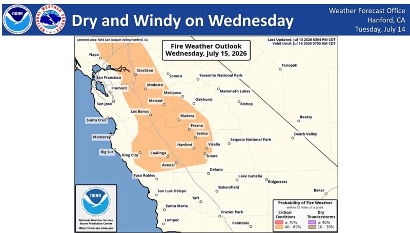
July 15, 2026 - National Weather Service Hanford Office officials report a Moderate Risk for Elevated Fire Danger will exist across portions of Central California.
In particular, the Coastal Range (West Hills) and a large part of the San Joaquin Valley, all north of Kern County.
These areas will observe strong wind gusts in the range of 20 to 30 mph and relative humidity down to 15 to 25 percent.
These conditions will allow for elevated fire danger as the dry grasses will experience enhanced ignition potential during the Wednesday and Thursday time frame.
Day 1 Fire Weather Outlook
NWS Storm Prediction Center Norman OK
1259 AM CDT Wed Jul 15 2026 Valid 151200Z - 161200Z ...
Synopsis...
Mid-level ridging will remain firmly over the CONUS Great Plains while a surface trough in southeastern MT brings dry and breezy conditions to portions of the northern High Plains. An upper trough and associated increasing southerly mid-level flow approaching the Pacific Northwest will support fast moving isolated thunderstorms with limited rainfall along and east of the Cascades in WA and OR. Hot and dry conditions in the CA Central Valley coupled with breezy onshore flow and downslope drying will promote a fire weather threat across portions of the CA coastal ranges and adjacent Central Valley. ...
California Coastal Ranges and Central Valley...
Onshore flow, downslope drying and higher winds through favored terrain will support elevated fire weather conditions across the central CA coastal ranges, adjacent Central Valley and portions of the southern CA coast. Winds from the west/northwest at 10-15 mph (locally 20-25 mph in favored terrain gaps), combined with RH of 15-20% in the coastal ranges to as low as 10% in the Central Valley, will promote elevated fire weather conditions this afternoon. Elevated highlights were extended southward to include the Santa Barbara Coast where localized sundowner winds of 20-30 mph will enhance the fire weather threat late this afternoon and evening.
Source: NOAA
