


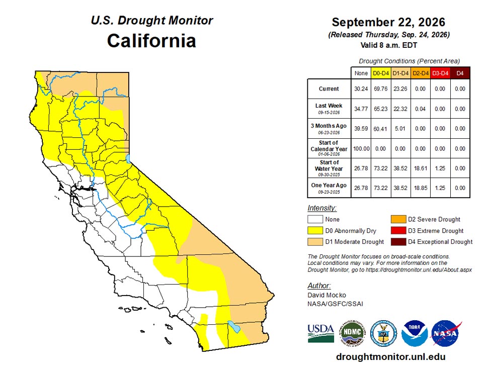
California and National Drought Summary for September 22, 2026
Summary
September 24, 2026 - The pattern of hot and dry in the south with heavy rainfall to the north of the high-pressure system continued over this past week. The highest precipitation amounts were from eastern Iowa and southeastern Minnesota to the east through southern Wisconsin, northern Illinois, to Ohio and West Virginia. Localized areas in this region received 6 to 8 inches of rainfall. Northeastern Kansas and northern Missouri received 3 to 5 inches, with western Nebraska to southeastern Montana picking up 2 to 3 inches. Monsoonal rain also fell in eastern Arizona to central New Mexico. Southern Florida also received several inches of rain over the week. Precipitation was very spotty and generally light, however, in Texas, Oklahoma, Louisiana, Arkansas, southern Missouri, and western Tennessee and Kentucky. Most of the west coast states had little rain.
Most of the south was again 5 to 10F above normal last week, peaking at over 15F above normal in parts of southern Missouri. Several states are setting records for continued warmth during this late summer to early fall period. The rest of the continental U.S. had generally near-normal temperatures.
Northeast
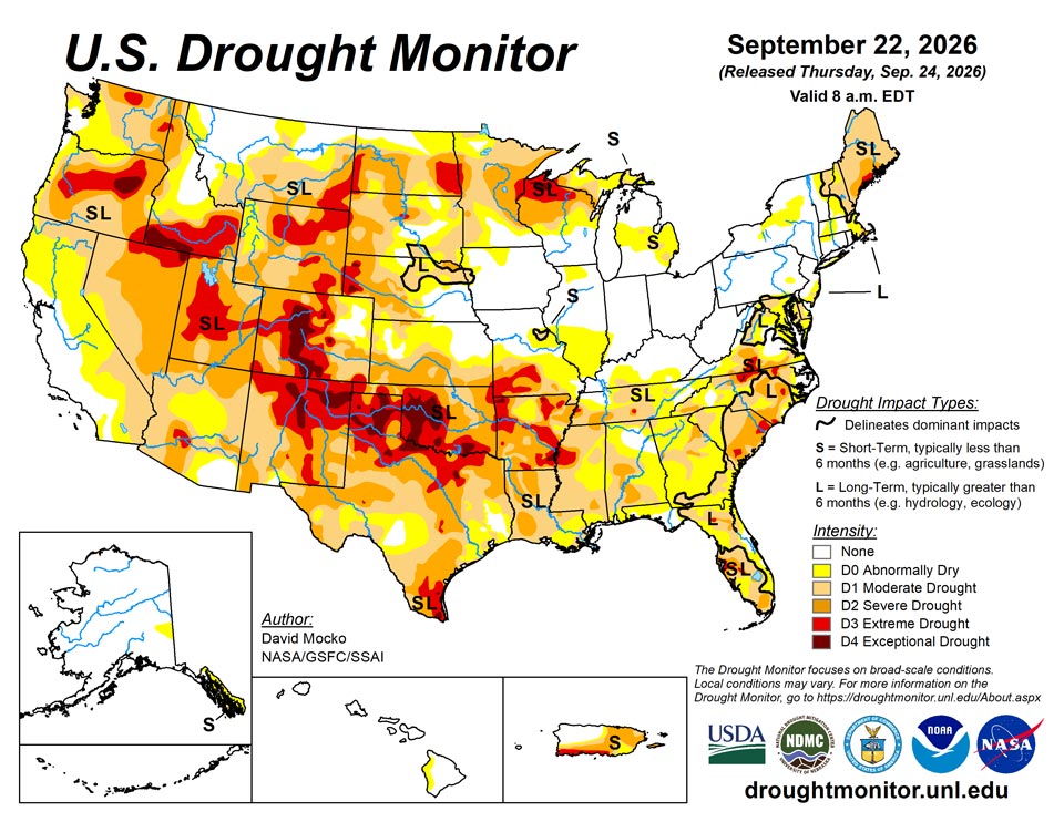
The heaviest rainfall in this region fell in Pennsylvania and West Virginia. Scattered lighter precipitation amounts over the past week were observed in the Northeast, leading to localized improvements to drought and abnormally dry conditions. An area of extreme drought is found along the Maine Coastline.
Southeast
Continued heat and generally dry conditions were observed in most of the Southeast. Degradations were made from southeast Virginia, to the eastern/central Carolinas, down to Georgia and Alabama. Meanwhile, most of Florida was wet, leading to improvements, especially over the southeast of the state. There were also small improvements in the Florida panhandle and in northern South Carolina from localized moderate rainfall. An area of exceptional drought continues in northern North Carolina, with patches of extreme drought from southern Virginia down to central Florida.
South
The continued heat and dry conditions resulted in large areas of degradations the past week. Extreme drought can be found in every state in this region, with exceptional drought over much of northern Texas, western to southern Oklahoma, and parts of Arkansas. Both short-term and long-term drought are contributing to the conditions in this region. Over the last year, west-central Oklahoma is the driest on record, while in southwest Oklahoma it has been the second driest.
Midwest
Southern Missouri was generally hot and dry this past week, with drought conditions deteriorating over much of the region. However, northern Missouri was wet leading to improvement in drought conditions. Southern Minnesota, eastern Iowa, southern Wisconsin, and northern Minnesota received significant precipitation, with over 8 inches falling in northeast Grant County, Wisconsin. The dry categories were thus improved in these areas. Northern Wisconsin, on the other hand, was dry with localized deterioration and the introduction of a small area of exceptional drought.
High Plains
Most of the High Plains received beneficial rainfall, resulting in improvement to drought categories over parts of all states in the region. More precipitation will be needed, however, to ameliorate the continued extreme drought over much of Colorado and Wyoming as well as parts of Montana, North and South Dakota, and western Nebraska. Areas of exceptional drought are still shown in much of central Colorado and western Nebraska.
West
Eastern Arizona to central New Mexico experienced monsoonal storms causing localized flooding and some drought improvement. Southern California and southern Nevada continued to be dry, leading to degradation of dry categories. Central Utah, central Oregon, southern Idaho, and northern New Mexico continue to be the largest areas of extreme to exceptional drought in this region, with smaller areas of extreme drought in a few other states.
Caribbean
A strong tropical wave moved over Puerto Rico during the past week and provided much-needed rainfall. Most of the region had improved drought conditions, with improved vegetation and soil moisture. Streamflows are still lower than normal in some locations.
St. Croix experienced highly variable and rainfall this week. The NWS/NOAA station at East Hill recorded 0.61 inches. The CoCoRaHS network recorded 0.87 inch at Christiansted 1.6 E (VI-SC-10), 0.68 inch at Frederiksted 1.7 ESE (VI-SC-20), 0.67 inches at Christiansted 6.5 W (VI-SC-23), 0.82 inch at Christiansted 1.7 SW (VI-SC-30), 1.27 inches at Frederiksted 1.9 NE (VI-SC-34) and 1.07 inch at Frederiksted 1.3 ENE (VI-SC-35). The largest amount occurring in the Frederiksted area. The groundwater conditions remained very poor. At Adventure 28 Well, the water level on September 12 was 26.1 feet, compared with 18.31 feet on September 22, 2025, indicating the water level was about 7.8 feet lower than a year earlier. These conditions indicate continued short-term extreme drought (D3-S).
This week, St. John experienced sparce rainfall although available observations are limited. The Rafe Boulon (VI-SJ-3) station at Windswept Beach recorded 0.21 inches, while the CoCoRaHS station VI-SJ-5 at Cruz Bay 1.6 E recorded 0.32 inches and station VI-SJ-10 at Cruz Bay 3.1 NNW recorded 0.03 inches. None of the stations measured over 0.3 inches of rainfall. At Susannaberg DPW 3 well, the water level on September 22 was measured at 18.93 feet below the land surface, compared to 11.2 feet on September 22, 2025. This 7.7-foot difference indicates the groundwater level is substantially lower now than it was a year ago. Observations showed that the depth continued to drop from the previous week, as well as 1- to 12-month precipitation indicators showing growing precipitation deficits. A heavy rain event that brought 1.5 to 2 inches of rain to the island at the beginning of September keeps St. John in short-term extreme drought (D3-S) conditions, though conditions are moving towards exceptional drought (D4-S) if beneficial rain does not happen in the next week or two.
St. Thomas saw little meaningful rainfall this week. While Cyril E. King Airport recorded no rainfall, CoCoRaHS station VI-ST-5 at Charlotte Amalie West 4.2 WNW measured 0.31 inches and station VI-ST-15 at Charlotte Amalie West 1.3 N recorded 0.09 inches. This continues weeks of dry conditions. On September 22, Grade School 3 Well levels were at 8.97 feet, slightly down from 8.4 feet the previous week and 3.2 feet lower than this time last year on September 22, 2025 (5.75 feet). The combination of low well levels, several weeks with little to no rainfall and 1- to 9-month precipitation indicators showing large precipitation deficits remain and St. Thomas, conditions were degraded to short-term exceptional drought (D4-S).
Pacific
Moderate precipitation over parts of Alaska resulted in reduction of abnormally dry regions in the state.
Hawaii is slowly recovering from tropical systems that passed nearby, with another system potentially coming close to the islands over the coming week.
Conditions across the Marshal islands brought intermittent showers and heavy rainfall for the northern islands keeping conditions status quo. This week, Utirik and Wotje recorded 1.75 and 2.58 inches respectively, though Ulirik is still in a precipitation deficit and has only recorded a little over half (4.27 inches) the necessary 8 inches per month. Elsewhere, after heavy rains last week, Ailinglapalap and Jaluit did not record any rainfall (1 day missing) while Kwajalein, Mili and Majuro received 0.54, 0.52 and 0.86 inches respectively. While Utirik did receive 1.74 inches this week, it follows several weeks of below adequate precipitation demand leading to the introduction of short-term abnormal dryness (D0-S).
The Federation States of Micronesia experienced varied rainfall with islands receiving well over 2 inches or under 0.15 inches. This week heavier rains fell across Chuuk Lagoon (2.30 inches, 1 day missing), Nukuoro (4.37 inches, 1 day missing) and Pohnpei (13.81, 1 day missing). Kosrae (0.25 inches, 5 days missing), Lukunor (0.14 inches, 2 days missing) and Kapingamarangi (0.02 inches, 1 day missing). Kapingamarangi has been below the necessary 2 inches a week for six weeks and has a monthly rainfall total of 3.08 inches leading to the degradation into short-term moderate drought (D1-S). Further west, there has been a short-term shift in weather towards the end of the week with monsoon showers bringing some short-term relief for Woleai (3.91 inches, 3 days missing), Ulithi (2.91 inches, 3 days missing) and Yap (4.73 inches, 1 day missing) before the dry pattern expected to return soon. Fananu and Pingelap had no data.
American Samoa saw generally decent rainfall. This week, Pago Pago received 5.6 inches (1 day missing), Siufaga Ridge 1.51 inches and Toa Ridge 1.74 inches (1 day missing). This week’s rainfall combined with last week’s heavy rainfall led to condition improving to short-term abnormal dryness (D0-S).
Palau experienced another week of inadequate precipitation and remain in short-term moderate drought (D1-S). This week with both Koror recording 1.87 inches while data was missing for WSO Palau/Airai. Conditions this week remain status quo with short-term moderate drought (D1-S).
This week, the Mariana Islands received heavy rainfall. Synoptic conditions favored active convection and locally heavy showers. Guam received an average of 4.09 inches this week with Antonio B Won Pat International Airport recording 5.64 inches, Agat 4.47 inches recording inches and Dededo recording 2.18 inches (2 days missing). Saipan averaged over 3.8 inches this week with Saipan International Airport recording 3.92 inches and Capital Hill recording 4.33 inches this week. Rota received 3.14 inches this week with the September monthly total already surpassing the necessary 4 inches (7.67 inches). Tinian had no data.
Looking Ahead
The next five days are forecast to be wet along the northeastern coast from a nor’easter. The northwest is also predicted to receive needed precipitation. Remnants of a tropical system will provide significant moisture into the Four Corners states and the western Great Plains with heavy rainfall in the forecast. Parts of the northern Great Plains are also forecast to receive welcome precipitation. Areas with little rain in the forecast over the next five days are much of Texas and Louisiana, around the Great Lakes, and California and Nevada. The south and southwest should continue to have above normal temperatures, with cooler temperatures in the northeast and the northwest.
The 6- to 10-day outlook (September 29 to October 3) favors above normal temperatures over the southern half of the continental U.S. as well as the northeast. Hawaii is also likely to have above normal temperatures. The Great Basin area could have below normal rainfall, while above normal is possible over much of the central U.S. Both Hawaii and eastern Alaska are also favored to have above normal precipitation during this period.
Author(s):
David Mocko, SSAI/NASA/GSFC
Lindsay Johnson, National Drought Mitigation Center
Dryness Categories
D0 Abnormally Dry—used for areas showing dryness but not yet in drought, or for areas recovering from drought.
Drought Intensity Categories
D1 Moderate Drought
D2 Severe Drought
D3 Extreme Drought
D4 Exceptional Drought
Drought or Dryness Types
S Short-term, typically less than 6 months (agriculture, grasslands)
L Long-term, typically more than 6 months (hydrology, ecology)
SL Area contains both short- and long-term impacts
Source: National Drought Mitigation Center
