


Monday Morning Update:
Yosemite National Park Dome Fire Monday Morning, September 28, Update: 5,215 Acres with 30% Containment; Glacier Point Road is Closed, Yosemite National Park is Open and Operating Normally
September 27, 2026 - Yosemite National Park Dome Fire Sunday Morning Update: 4,809 Acres with 30% Containment.
10:00 A.M. Update
Status:
• The fire has increased 311 acres since yesterday morning and is now 30% contained.
• The fire continues to move slowly north and northeast into the 2017 Empire Fire footprint, where rocky terrain and natural barriers are helping slow its spread.
• While higher humidity is expected today, higher winds can result in longer range spotting.
• Crews are building and widening fire lines near Bridalveil Creek, Empire Meadows and Horse Ridge.
• In Wawona and Yosemite West, crews are clearing brush around homes, checking hydrant pressure and keeping roads open.
• No roads, buildings or utilities are under immediate threat.
• Visitors may continue to see or smell smoke as conditions change.
Weather: Cool temperatures and elevated humidity are providing firefighters with better conditions to strengthen containment lines. Expect strong south to southwest winds with gusts reaching 25 mph through the weekend.
Temporary Trail Closure: Yosemite National Park is open and operating normally, with the following exceptions. Glacier Point Road is closed due to reduced visibility from smoke and to safely allow firefighting operations. There are no imminent threats to infrastructure. The Four Mile Trail and Panorama Trail, providing access to Glacier Point, will remain open to hikers. Glacier Point Road will reopen when conditions allow. Backpackers already parked overnight at Glacier Point will be allowed to exit after the closure begins. The Chilnualna Falls trail, as well as the trails from the top of Chilnualna Falls toward Buena Vista and Crescent Lakes, are closed due to the Dome Fire. (These lakes are reachable from the east.) Ostrander Trail and all areas and trails south of it are closed. The closed area extends east of the Wawona Road from Wawona to Chinquapin, as seen on the public information map. View the full Closure Order, and Closure Order Map
Smoke Impacts / Air Quality: GOOD air quality today for Wawona, El Portal, Hodgdon Meadow, and Mariposa. Southwest winds will bring smoke to Tuolumne Meadows beginning in the late morning and continuing through the afternoon. Air quality is expected to be UNHEALTHYFOR SENSITIVE GROUPS with periods of heavier smoke possible. Air quality for Yosemite Valley is expected to be MODERATE.
View current Air Quality Monitoring at https://fire.airnow.gov/#7/38.532/-119.416
Managing Fire Impacts in Federal Wilderness. While it is widely understood that motorized equipment such as off-highway vehicles, dozers, or other mechanized equipment are not allowed in wilderness, this requirement is also largely true when fighting fires in wilderness. Chainsaws, small portable water pumps and similar equipment is often allowed to operate during active fires, but large, ground disturbing equipment is still prohibited. Firefighters use other methods, called Minimal Impact Suppression Tactics (MIST) when fighting fires in Wilderness areas. Read more .
Equipment Recovery and Backhaul: While firefighters make the final push towards containment of the fire, they must fulfill another extremely important task. Firefighters must be on the lookout for equipment in the field that is no longer needed by the crews that fought before them and recover and return items as activities continue to wind down.
The list of equipment that must be retrieved includes; hose, pump kits; generators; chainsaw kits; collapsible water tanks; and smaller items such as hose fittings and nozzles. To gather these items, firefighters will GPS the location of equipment and then crews are sent out to backhaul these items. Equipment must then be cleaned, repaired, and organized to be ready for the next incident.
Early Sunday Information:
| Total Personnel: | 775 |
|---|---|
| Size | 4,809 Acres |
| Percent of Perimeter Contained | 30% |
| Fuels Involved |
Standing closed canopy timber is producing active fire behavior and spotting, adjacent fuels become less continuous with scattered timber, brush, grass, and exposed granite hillsides. Red fir fuel type with montane shrub and brush understory interspersed with pockets of nonburnable fuels in granitite rock outcrops. Fir trees are large diameter and over 100 ft tall and suffer from insect and disease mortality, leading to significant snag component and large amounts of heavy dead and down coarse woody debris. Most active fire behavior has come from the dense, closed canopy red fir stands, where torching and isolated crown fire pockets have also contributed to spotting. Fuels in 2017 fire footprints have less closed canopy but contain significant dad and down with standing snags, increasing spotting potential. Montane shrubs and brush in the understory are generally available to burn but are not at critical fuel moisture levels. Heavy dead and down fuels are dry, with fuel moisture in 1,000 hr. fuel below 10%. Active burning in recent days illustrates a fuel complex that is generally available across all types and size classes. |
| Significant Events |
Active Fire Behavior was observed with isolated torching, flanking and creeping. Fire has continued to spread to the north and northeast via surface spread in heavy fuels and short to medium range spotting (between ¼ to ½ of a mile). The red fir fuel type has a significant dead and down component and is highly conducive to both ember production as well as ember reception, leading to frequent spotting. Wind alignments from the south and west increase spotting to the north and northeast, with a noteworthy large spot fire established east of Tanner meadow on the SW facing slope. The heavy fuel loading presents resistance to control issues for ground resources, reducing line production rates, though numerous granite outcroppings and bare areas provide some opportunities for using natural barriers. To the north, fire growth is expected to slow as it encounters the footprint of the 2017 Empire Fire. Threats to values at risk and potential fire behavior are greatest as the fire moves downslope to the west and southwest, where heavier mixed conifer fuels increase potential for fire behavior that would challenge ground resources. The fire remains wholly within the wilderness area of Yosemite National Park and is expected to stay that way through the forecast period. |
| Current as of | Sun, 09/27/2026 - 09:25 |
|---|---|
| Incident Time Zone | Pacific Standard Time |
| Incident Type | Wildfire |
| Cause | Human - Abandoned Campfire |
| Date of Origin | |
| Incident Time Zone | Pacific Standard Time |
| Location | North of Wawona Dome |
| Incident Commander | California Complex Incident Management Team 3, Incident Commander Oscar Vargas. |
| Incident Description | The fire has a moderate rate of spread to the north and northeast. Firefighters have been utilizing natural barriers, and line has been secured on the south and west sides of the fire. The fire is deep in the wilderness and difficult to access due to steep, rugged terrain. |
| Coordinates | 37° 33' 58'' Latitude -119° 36' 82
'' Longitude |
| Planned Actions |
Construct direct handline where topography and fire behavior permit. Strengthen secondary and contingency lines. Employ rotary-wing aviation assets to check fire spread, moderate flame lengths to thresholds suitable for direct attack. Continue to identify and construct helispots and sling sites to support operational mission. |
|---|---|
| Projected Incident Activity |
12 hours: Continuous backing and flanking to the west are anticipated along the northwest corner of the incident footprint. Along the northern perimeter, isolated timber stringers will perpetuate localized torching, shortrange spotting, and creeping surface fire growth. The eastern perimeter will continue flanking, with short, uphill, wind-driven runs expected in areas of continuous fuel. Overall perimeter growth will remain low. 24 hours: While decreasing temperatures and slightly higher relative humidity will provide minor moderation, fire behavior will be challenged by an increase in surface winds. Elevated mixing heights and strong transporwinds will directly confront the eastern and northern flanks of the incident. While there are substantial natural barriers such as rock outcroppings, the increased winds will create an increase in spotting and potentially increased rates of spread. This will challenge overall containment; however, the primary spread will be away from values at risk. 48 hours: the highest potential for light precipitation occurs in the 48-hour timeframe. This will come with much cooler temperatures and increased cloud cover and elevated humidity resulting in decreased fire behavior. Expect surface spread rate to be slow with spotting still presenting the largest spread mechanism. As the low pressure exits to the east in the evening, it will create moderate to strong N/NE winds, especially overnight. While these will occur during a period of reduced fire potential, they will nonetheless exacerbate spotting in the red fir and lodgepole, especially toward the Alder Creek drainage where continuous fuels exist with high loading in an area with no recent fire history. While major fire spread is not expected, this could present a challenge for the western flank of the incident. 72 hours: The combination of increased relative humidity, lower temperatures, and moderating wind speeds will suppress fire behavior. Activity is expected to remain minimal even as the probability of precipitation departs the area. Anticipated after 72 hours: A warming and drying trend will return to the fire area, bringing incremental increases in potential fire behavior. Expect surface spread to remain minimal for 1-2 days following the cool and humid weather in the 48-hour period, meaning that a return to growth of ¼ a day will not be until past the 72-hour timeframe. |
| Weather Concerns |
Slightly cooler temperatures were observed today along with little overall change in relative humidity. South to southwest winds of 4–8 mph with gusts to 15–20 mph was also observed around the fire. Expect mostly sunny skies with a few clouds over the Sierra, though high clouds will gradually push over the fire area this afternoon. 12-Hour Overnight: Southeast winds 4–7 mph are expected overnight as an inversion develops during the evening. Humidity recovery will generally be good, with readings reaching the 50s. Temperatures will fall into the 40s and 50s. 24–72 Hour Forecast: Low pressure will continue to approach the area, bringing cooler temperatures, increasing humidity, and stronger southwest winds Sunday. Wind gusts on Sunday are expected to reach around 25 mph. Mid- and high-level clouds will increase overall. As the weather system pushes into the region, there is a 20% chance of afternoon showers and a 10% chance of thunderstorms on Monday; however, the greatest threat will remain over the Sierra Crest. Rainfall amounts look fairly light, with totals expected to range from a trace to a few hundredths of an inch. Monday will be the coolest day, with temperatures 5–8 degrees below normal putting highs in the upper 40s to mid-50s. This will also boost relative humidity, with minimums in the 40–50% range. The system responsible for this cooler, unsettled weather will move east, allowing high pressure to build back into the region. Warming temperatures, drier conditions, and lighter winds will return Tuesday. Daily inversions will lift by mid- to late morning. Extended (Beyond 72 Hours): High pressure will be over the region through much of next week, bringing increasing temperatures, decreasing humidity, typical diurnal winds, and continued dry conditions |
|---|
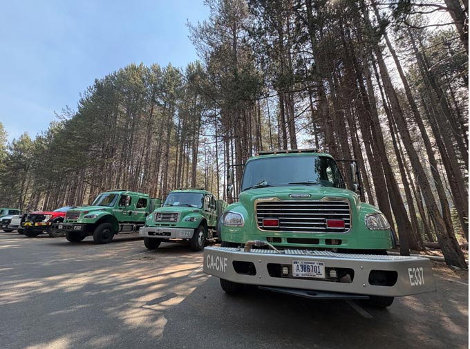
Forest Service Engine Strike Team at the Dome Fire
Previous Information
