


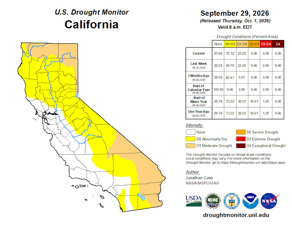
California and National Drought Summary for September 29, 2026
Summary
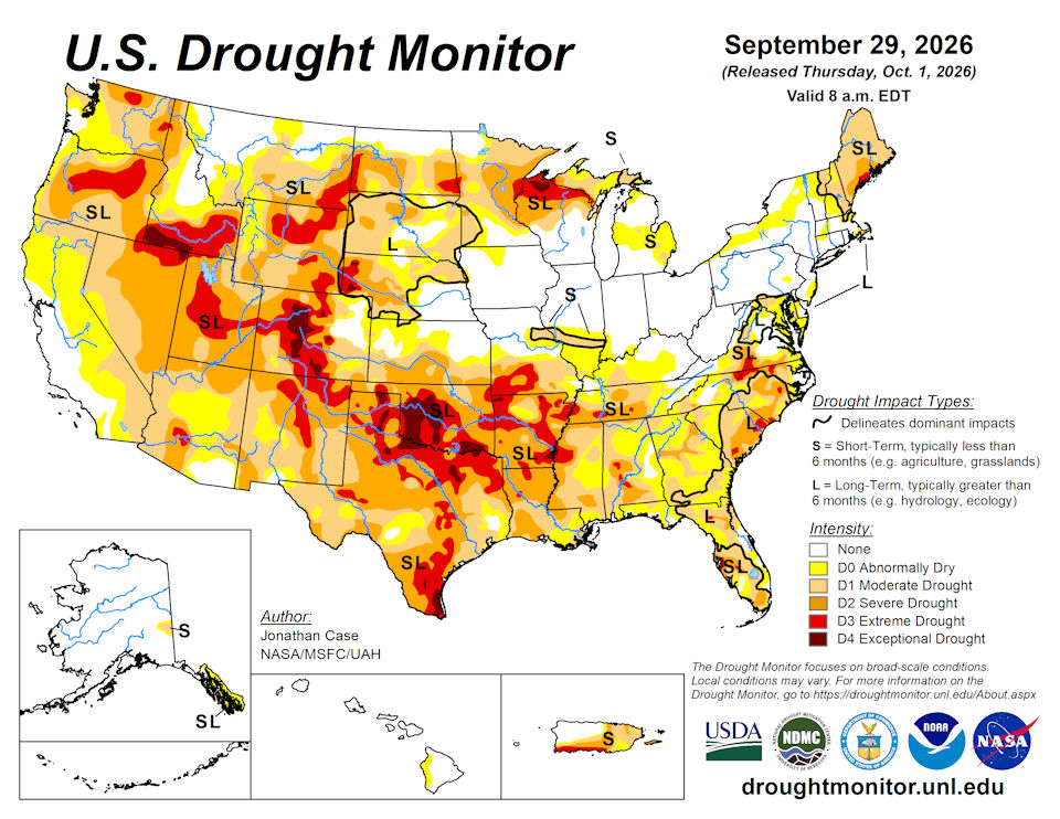
October 1, 2026 - This week featured a dynamic and changeable drought environment across the country, partially thanks to the rapidly intensifying El Niño resulting in much above-average temperatures in the eastern Pacific waters. These warm ocean temperatures have been fueling numerous hurricanes in the East Pacific; three of which indirectly impacted the Unites States. Hurricane Nolo affected parts of the Hawaiian Islands with heavy rains, although mainly impinged on the east-facing slopes that are not in any drought or unusually dry conditions. Meanwhile, moisture from Hurricanes Odalys and Polo both contributed to a near-record moist environment over the normally dry Desert Southwest. Very heavy rains fell on much of New Mexico, and parts of Arizona, Utah, and Colorado both early in the period and again on Monday and Tuesday when Hurricane Polo curved northeast into the Baja of California and tracked into southern New Mexico. Weekly rainfall totals were very impressive across the Southwest, with totals reaching 5-10 inches, accounting for a large portion of the annual rainfall in some places. The heaviest rains fell across eastern New Mexico into northwestern Texas, helping to alleviate drought conditions. Beneficial rains also extended into southern and eastern Colorado into western Kansas and Nebraska, leading to drought relaxation. Coastal New England and the Mid-Atlantic states experienced a substantial Nor’easter that produced heavy rain, gusty winds, and storm-surge flooding from Delaware and New Jersey up to New York’s Long Island and southeastern Massachusetts.
The south-central and southeast states were not so fortunate this past week, however. Continued unseasonably hot dry conditions prevailed across the rest of Texas and Oklahoma eastward into the Tennessee River Valley, leading to worsening drought conditions in many states. The combination of persistently hot weather with virtually no rainfall during much of August and September has led to rapid onset drought in much of Texas and Oklahoma, resulting in widespread severe, extreme, and exceptional drought coverage, which again intensified this past week. Intensifying dryness and drought also prevailed across Arkansas, Louisiana, Mississippi, Alabama, Tennessee, and Georgia. And for those residing up north, the upper peninsula of Michigan and northern Wisconsin continues to suffer with worsening drought as precipitation was again meager there this past week. Outside of the Southwestern states, the remainder of the western U.S. had fairly steady-state drought conditions this past week, with only a few improvements occurring in the northern Rockies and in Oregon.
Northeast
The northeastern states experienced seasonable temperatures within a few degrees of normal for this time of year. The main noteworthy weather feature was the Nor’easter that produced beneficial rainfall up to several inches along the New England coast, southward into New York, New Jersey, Delaware, and Maryland. Drought improved in these areas but concerns over slowly-recovering groundwater and well levels prompted a retention of abnormal dryness and/or moderate drought levels in most coastal locations that have experienced long-term drought this past year. Drought persists in most of Maine, as very little rain from the Nor’easter reached the drought-stricken state.
Southeast
The Southeastern states were a mixed bag, with Virginia and North Carolina experiencing several inches of beneficial rainfall earlier in the week, leading to drought improvement, especially in the western parts of these states. Some abnormal dryness and moderate drought set in over far southeastern Virginia and the northeast coast of North Carolina. Florida was also a mixed bag, experiencing some improvements around Miami metro where 1-4 inches of rain fell this past week. But as is typically the case for Florida summers, rainfall was spotty so some areas had slight degradations in drought conditions, which has been persistently stubborn across Florida this summer. Alabama and Georgia were mostly dry, and despite the return to near-seasonably normal temperatures, both states had worsening drought with the addition of severe and extreme drought categories this week, largely contributed by the extraordinary September heat wave.
South
The southern states have taken the brunt of recent drought intensification since August, which continued this past week across most of Oklahoma and Texas. Worsening drought also occurred across most of Arkansas, Louisiana, Mississippi, and Tennessee. Virtually no rain fell this past week in this region except for far western Texas, the Oklahoma Panhandle, and eastern Tennessee. Combined with temperatures of 6-12 degrees above average, the lack of rainfall contributed to the rapid intensifying drought. Most of central and eastern Texas, Oklahoma, and Arkansas are under severe, extreme, or exceptional drought classifications. Louisiana, Mississippi, and Tennessee are quickly degrading as well into severe to extreme drought conditions due to the September heat wave and continued lack of rainfall. Much of Texas and Oklahoma need to receive 20 to 25 inches of rainfall over a 3-month span to break out of the present drought. The lone exceptions to the drought worsening were in far western Texas and the western Oklahoma Panhandle, where several inches of rain fell as eastern Pacific tropical moisture associated with Hurricanes Odalys and Polo moved across the region. Far eastern Tennessee experienced temperatures around 3 degrees below normal along with the plentiful rainfall resulting in no drought conditions.
Midwest
The Midwestern states covered a broad range of conditions ranging from extreme to exceptional drought in northern Wisconsin, to excessive wetness from prolific rainfall all summer from Iowa to Ohio, where very little drought or abnormal dryness is present this week. This persistent storm track has separated the southern drought from the northern drought. This past week, the long-term drought in Minnesota experienced some relief as up to 5 inches or more of rain fell over an area of severe to extreme drought near the North Dakota border, leading to relief there. Northwestern Minnesota completely relaxed out of drought this week as more beneficial rain fell there. Extreme to exceptional drought persisted in northern Wisconsin where little rain fell this past week. The drought also spread this past week into Michigan’s Upper Peninsula with an unusual lack of rainfall in late September intensified drought to between moderate and extreme levels. Nearly 15 inches of rain needs to fall in a 3-month span to fully recover from the present drought in northern Wisconsin and the upper peninsula of Michigan. Drought also continued to intensify this week across southern Missouri.
High Plains
The High Plains states experienced almost exclusively drought improvements this week, as many areas experienced beneficial rainfall, with Colorado, Kansas, and Nebraska being beneficiaries of the east-Pacific “El Niño” tropical connection. Despite temperatures being up to 6 or more degrees above average, the plentiful rainfall has contributed to drought improvement in many areas this week. Northern and eastern North Dakota also experienced substantial reduction in drought coverage and intensity as heavy rain fell near the Canadian border.
West
Outside of Arizona, New Mexico, and Colorado, which experienced deep and substantial drought-busting rainfall this past week, the western states generally had unchanging drought conditions. The Pacific Northwestern states of Washington and Oregon began experiencing the first of its fall rainy systems, helping to ease drought pressure across western Oregon, where drought was downgraded in a couple spots. Drought and dryness also improved in southwest Montana and northwest Wyoming this past week.
Caribbean
While some drought impacts remain over Puerto Rico, the commonwealth has received significant rainfall in areas over the last 30 days. This has allowed some of the water reservoirs to be replenished. In the same timeframe, rainfall deficits have eased or even switched to a surplus. Improvements to the Puerto Rico drought can be found this week in both the southwest and eastern parts of the island.
The U.S. Virgin Islands received scant precipitation over the past week as St. Thomas remained in exceptional drought, while St. John and St. Croix were in extreme drought. Citizen weather observers (CoCoRaHS) on St. Thomas reported 0.1 inches or less for the week. St. Thomas received from 0.24 to 0.57 inches. Rainfall on St. Croix was abysmally low at 0.12 inches or less.
The Standardized Precipitation Index (SPI) values were consistent with the drought status of each island for the most part. The SPIs for St. Croix are entering the D4 range, with values for the 1-, 9-, and 12-month SPIs indicating less intense drought, so St. Croix was kept at D3 this week. Exceptional drought may be on the horizon for St. Croix.
The Vegetation Health Index indicates some significant stress for all islands. Water levels in wells on all three islands are dropping as the intense dryness continues.
Drought and heat are causing increased mortality for livestock, poultry and wildlife. There are also issues with water production from desalination and with water distribution.
Pacific
The interior Tanana Valley of east-central Alaska has been abnormally dry over the past several months, leading to the issuance of a moderate drought category there. In the Southeastern Alaskan Panhandle, the normal wet season for this time of year has begun, but given the prevailing wet climate regime, much more precipitation needs to fall to completely erase the prolonged dryness and moderate drought of this summer.
Hawaii was impacted by yet another Hurricane (Nolo) this past week, bringing prolific rainfall particularly to the Big Island. However, since most of the heavy rain fell on the favorable east-facing windward side of the Big Island, the abnormal dryness was allowed to remain in this week’s drought map along the rain shadow of the west coast.
Tropical Depression 26W was east of the Mariana Islands and moving westward. To the south, a monsoon surge was developing across central Federated States of Micronesia and southeast of Guam.
The Republic of Palau was at D1 and received 1.46 inches of precipitation at Palau IAP. No precipitation was reported for Koror. Month-to-date precipitation for Palau IAP on the last day of September was 4.18 inches, less than a third of normal precipitation for the month. These islands need 2 inches of rain per week to meet minimum water needs.
The Mariana Islands received more than an inch for the week, except for one Saipan location. One inch is the weekly amount these islands need to meet minimum water needs. Guam reported 1.52 inches, Rota got 1.76 inches, and Saipan IAP collected 2.31 inches.
The Federated States of Micronesia were mixed for the week. Kapingamarangi remains at D1 and received a mere 0.02 inches of rain. Precipitation was also low for Kosrae, Lukunor and Nukuoro. Chuuk, Pohnpei, Ulithi, Woleai and Yap all received more than 3 inches.
Some of the Marshall Islands received ample precipitation, while other islands did not. Utirik reportedly received 3.22 inches of precipitation, so the D0 label was removed. Locations with less than 2 inches of rain included Majuro with 1.5 inches and Mili with 0.58 inches. Ailinglaplap, Jaluit, Kwajalein and Wotje all collected more than 2 inches of rain, which is the amount to cover minimum water needs.
American Samoa remained at D0 as rainfall had been below normal, but precipitation has improved in recent weeks. Pago Pago received 0.94 inches of rain, while Siufaga Ridge and Toa Ridge received 4.48 and 2.22 inches, respectively. These islands require 2 inches of rain per week to meet minimum water needs.
Looking Ahead
Ongoing substantial rain was falling Tuesday morning at the onset of the new U.S. Drought Monitor week, from Arizona and New Mexico into the Central and High Plains. This excessive rainy system connected to Hurricane Polo is projected to continue eastward this week into the High Plains, Midwest, and South regions. The Weather Prediction Center has moderate threats for excessive rainfall from the Southwest into Texas, Oklahoma, northward into Nebraska and Iowa. Drought-busting rains may be possible across the South as this weather system evolves this week. Looking into the next week, the Climate Prediction Center’s 6–10-day outlook indicates that well-above average temperatures will shift into the western states, along with below normal precipitation chances. Meanwhile, above average precipitation chances are projected from southern Texas into the southeastern states, including Florida. Above average precipitation chances are also projected for southeastern Alaska, with near neutral rainfall forecasts for Hawaii.
Author(s):
Jonathan Case, NASA/MSFC/UAH
Denise Gutzmer, National Drought Mitigation Center
Dryness Categories
D0 Abnormally Dry—used for areas showing dryness but not yet in drought, or for areas recovering from drought.
Drought Intensity Categories
D1 Moderate Drought
D2 Severe Drought
D3 Extreme Drought
D4 Exceptional Drought
Drought or Dryness Types
S Short-term, typically less than 6 months (agriculture, grasslands)
L Long-term, typically more than 6 months (hydrology, ecology)
SL Area contains both short- and long-term impacts
Source: National Drought Mitigation Center
