


California and National Drought Summary for December 13, 2016
Summary
December 15, 2016 - During the first half of the U.S. Drought Monitor week, one low pressure system tracked from the North Dakota/Minnesota border towards James Bay, Canada to the mouth of the St. Lawrence Valley, while a second low pressure system raced from the Lower Tennessee Valley to the mid-Atlantic coast. The first storm system brought moderately heavy snow to the Great Lakes region (especially downwind areas) and gusty winds to North Dakota and Minnesota, while the second storm was accompanied by widespread rainfall. During the second half of the Drought Monitor week, another frontal system moved across the central and eastern Lower 48 states, bringing additional precipitation to those regions.The Northeast, Mid-Atlantic, and Great Lakes region
Lake-enhanced snowfall (1.5-3.0 inches liquid equivalent precipitation) downwind of Lakes Erie and Ontario resulted in one-category improvements to the drought depiction in portions of extreme southwestern New York, and also the Syracuse/Oswego area in central New York. Severe drought (D2) areas in northern New York and adjacent Vermont were improved to moderate drought (D1), to be more consistent with local conditions. In Massachusetts, D2 was reintroduced to much of Bristol, Plymouth, and Norfolk Counties, as conditions there have deteriorated. However, abnormal dryness (D0) was removed from Nantucket after reassessment of precipitation departures from normal and reports from local experts. Some improvement was noted along the western parts of the moderate drought (D1) area in northern Virginia and central Maryland, though several low reservoirs in this area suggest regional improvement could be slow. The impact lines and labels were reassessed this week across these areas, based on departure from normal precipitation (DNPs) out to 180-days, and on the latest drought blends.The Southeast/Lower Mississippi Valley
In North Carolina, the depiction remains unchanged this week. Recent rainfall (from several weeks ago) and cooler temperatures have provided some relief in overall drought conditions across the western part of the state, but not enough to warrant a one-category improvement at this time. A reassessment of conditions across South Carolina supported a one-category improvement (from extreme drought to severe drought, D3 to D2) across portions of Upstate South Carolina. No changes were rendered in northern Georgia, where drought continues to be entrenched. For example, Lake Lanier is now 9.11 feet below full “winter” pool. In southern Georgia, a southwest-to-northeast oriented heavy rain band (generally 4-8 inches, locally higher, in the past 14-days) warranted one-category improvements to the area. In nearby Alabama, targeted one-category improvements were rendered to the depiction where localized swaths of heavy rainfall were observed. This primarily included central and southeastern Alabama, though very minor adjustments were also made in a few far northern counties, from D3 to D2. The band of heavy rain that recently resulted in significant improvements across southern portions of Alabama and Georgia also resulted in the removal of severe drought (D2) from the western Florida Panhandle. Widespread improvements were also incorporated into the Louisiana and Mississippi depictions, based largely on heavy rains several weeks ago. The impact lines and labels were reassessed this week across these areas, based on departure from normal precipitation (DNPs) out to 180-days, and on the latest drought blends.Tennessee and Ohio Valleys
Continued improvements were noted across portions of Kentucky this week, based on recent beneficial precipitation. This included the removal of extreme drought (D3) from the state, and other improvements in northwestern, northern, and southeastern parts of the Bluegrass state (from D2 to D1). The impact lines and labels were reassessed this week across these areas, based on departure from normal precipitation (DNPs) out to 180-days, and on the latest drought blends.Northern and Central Plains
Recent snowstorms across the northern Plains justified the removal of abnormal dryness (D0) across much of south-central North Dakota. This is clearly supported by the Advanced Hydrologic Prediction Service (AHPS) 60-day Percent of Normal Precipitation (PNP) map, which shows precipitation amounts have ranged from 150-300 percent of normal. Having made substantial revisions to the South Dakota depiction last week, no changes were deemed necessary. The one exception was the Impact Label, which was modified to include both short-term and long-term impacts (SL), to be more representative of conditions across the Black Hills region.Southern Plains
Primarily deteriorations were made to the depiction in Oklahoma and Texas this week. Severe drought (D2) was expanded across the Panhandle region and into adjacent counties of northwestern Oklahoma. Severe drought was also expanded across central portions of the state, while moderate drought (D1) areas were merged across central Oklahoma. In extreme eastern Oklahoma, lack of rainfall and dry ponds warranted a one-category degradation across central and northeastern portions of Wagoner County, and across much of Mayes County. The impact lines and labels were reassessed this week across these areas, based on departure from normal precipitation (DNPs) out to 180-days, and on the latest drought blends.Rockies/Intermountain Region
No alterations were made in these areas this week. Idaho experts note there is still some low snowpack in the far eastern county of Clark and environs, while, in contrast, conditions in the Owyhee Mountains (located in the southwestern part of the state) have improved. Some improvements in the Idaho depiction may be forthcoming in the weeks ahead, especially if the current wet pattern continues.Pacific Northwest and California
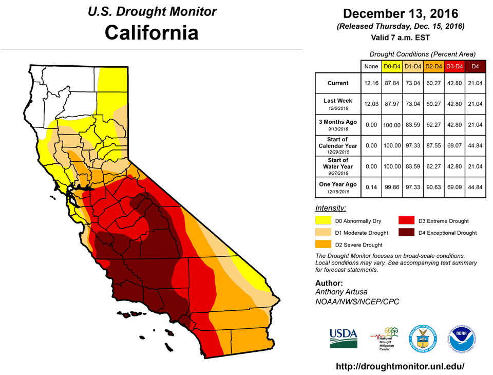
Water Year to Date (since Oct 1) PNPs are well above-normal (mostly 125-200 percent) in much of Washington, western Oregon, and a large fraction of the northwestern half of California. Across the far southeastern California deserts, practically no rain has fallen since Oct 1, with PNPs ranging within the lowest 25 percent of normal. As this is still fairly early in the Water Year (WY), and reservoirs and groundwater supplies are still being assessed and evaluated, no changes were deemed necessary to the regional depiction this week.Hawaii, Alaska, and Puerto Rico
Despite some rain falling across the drought areas in Hawaii during the past week, resulting impacts have yet to be determined. Therefore, no changes were made in Hawaii, as well as in Alaska. There is currently no drought in Puerto Rico.Looking Ahead
Expected precipitation in the next five days (December 15-19) is expected to be moderate to heavy (1.0-2.5 inches) from the central Gulf Coast area north-northeastward across the Tennessee and Ohio Valleys, the Great Lakes region, the mid-Atlantic, and the Northeast. Though this will be beneficial to these regions, it may not be quite enough to justify a one-category improvement for next week. For South Dakota, precipitation amounts are anticipated to range between 0.5-1.0 inch. In the higher elevations of the northern and central Rockies, and for the Mogollon Rim in central Arizona, precipitation amounts are forecast to range from 1.5 to 3.5 inches (liquid equivalent). Coastal California is also anticipated to receive significant precipitation during this period, on the order of 1.5-2.5 inches. Higher amounts (perhaps up to 10-inches, liquid equivalent) are forecast in the climatologically wetter areas of far northwestern California, and the Sierras. For the ensuing five-day period (December 20-24), above-median precipitation is favored for the Lower Mississippi and Tennessee Valleys, the Southeast and southern mid-Atlantic, the Pacific Northwest and northern Rockies, and nearly all of Alaska. Odds favor below-median precipitation from California eastward across the Four Corner states, continuing northeastward across the northern and central Plains, and Middle and Upper Mississippi Valley.Author(s):
Anthony Artusa, NOAA/NWS/NCEP/CPC
Dryness Categories
D0 ... Abnormally Dry ... used for areas showing dryness but not yet in drought, or for areas recovering from drought.Drought Intensity Categories
D1 ... Moderate DroughtD2 ... Severe Drought
D3 ... Extreme Drought
D4 ... Exceptional Drought
Drought or Dryness Types
S ... Short-Term, typically <6 months (e.g. agricultural, grasslands)L ... Long-Term, typically >6 months (e.g. hydrology, ecology)
Source: National Drought Mitigation Center

