


California and National Drought Summary for January 3, 2017
Summary
January 5, 2017 - A series of fast-moving Pacific storm systems raced eastward across the lower 48 States this week, bringing light to moderate precipitation to the Northwest, California, and along the southern tier of states. Once the systems reached the Southeast, they tapped moisture from the Gulf of Mexico and produced widespread and numerous heavy showers and thunderstorms, some severe, from southeastern Texas northeastward into the Carolinas. Copious rains fell across much of the Southeast, with more than 4 inches measured from extreme southeastern Texas northeastward into south-central South Carolina. Locally, 7-12 inches of rain was dumped on southern Mississippi northeastward into west-central Georgia. These rains fell on much of the Southeast drought area and provided welcome relief, especially in southern sections. Lighter precipitation (0.5-2 inches) also fell on most of the Northeast and Ohio Valley, including heavy snow (up to 2 feet in Maine) that blanketed parts of northern New England. Unfortunately, little or no precipitation fell on the Nation’s mid-section, particularly the south-central Plains and lower Missouri Valley, where above-normal temperatures and lingering dryness dating back to the Fall has generated impacts in Oklahoma that were worse than what the data indicated. Weekly temperatures averaged below-normal in the West (anomalies -10 to -15 deg F in the Interior Northwest and Great Basin) and much above-normal in the eastern half of the Nation (anomalies 10-15 deg F in the southern Great Plains and along the western half of the Gulf Coast).The Northeast
Light to moderate precipitation (0.5-2 inches) fell on much of New England, the mid-Atlantic, and eastern Great Lakes region which was adequate to prevent any further deterioration but not enough to warrant improvement. The exceptions to this included higher weekly totals in Maine (1.5-2.5 inches liquid equivalent) where most of this fell as heavy snow (up to 2 feet) in interior southern Maine, and this was enough to remove D2 in the state. Just to the south, 1-1.5 inches of precipitation was observed in eastern New Hampshire, east-central Massachusetts, eastern Connecticut, and Rhode Island. Since deficits have lingered longer in this area than in Maine, D2 was kept, but D3 was erased as USGS 1-, 7-, 14-, and 28-day average stream flows were in the normal (25-75th percentile) range. The recent increase in precipitation since early December plus low temperatures and minimal evaporation have slowly increased the soil moisture, including ground water recharge as only 7 of 17 wells in northeastern Massachusetts were still below the 25th percentile. In the central Appalachians, 1.5-2.5 inches of precipitation in southeastern West Virginia and southwestern Virginia eliminated short-term (out to 90-days) deficits, thus D0 was erased while some D1 went to D0 in southwestern Virginia.The Southeast
2017 started out very wet and stormy in the Southeast as waves of low pressure tracked along a stationary front draped across the Deep South, tapping humid and warm Gulf air. With showers and thunderstorms developing on Dec. 31 and mostly continuing until the end of the period (12Z Tuesday), between 4 and 10 inches of rain had fallen on the southern thirds of Louisiana and Mississippi, southern half of Alabama, extreme western Florida Panhandle, central Georgia, and south-central South Carolina. Moderate rains (1-4 inches) occurred in southeastern Texas, most of Louisiana, eastern Arkansas, northern Mississippi, much of Tennessee, most of Kentucky, northern thirds of Alabama and Georgia, and most of the Carolinas. With the added benefits of increased and surplus precipitation since early December, lower temperatures, minimal evapotranspiration, lower water demand, and less time in extreme drought than northern areas, the rainfall was especially beneficial across southern Southeast drought sections. This resulted in a 1- or 2-category improvement, and in a few areas (southern Alabama), a 3-category improvement (D3 to D0; D2 to D-nada) where rainfall exceeded 8 inches and the SPIs out to 6-months were either wet or normal. USGS 1-, 7-, 14-, and 28-day average stream flows remained in the normal to above-normal range in this area as of January 3. Farther north, the amounts were lower but still significant (2-4 inches), allowing for a 1-category improvement across the northern interior Southeast drought area, including the removal of the entire D4 area. Although the rains put a dent in the long-term drought, much more rain will be needed, especially across northern sections (northern Alabama, northern Georgia, western Carolinas), to erase the drought. Although SPIs at 2-months were greatly improved, SPIs at 3-, 4-, 6-, and 12-months were still very low, and 6-month deficits of 8-12 inches remained. Lake Lanier was still about 9.5 feet below winter full pool. Although the decent rains missed the southern Atlantic coast (eastern sections of South Carolina and Georgia, most of Florida), 90-day surpluses remained in the first two areas while Florida is in their normal dry season. Even though December was rather dry across much of the state, pasture conditions rated poor or very poor barely changed, moving to 32% on Jan. 1 from 30% on Nov. 27. Therefore, no changes were made in eastern South Carolina and Georgia, and the remainder of Florida (outside of the Panhandle).Midwest
Precipitation was minimal across much of the region, with the largest totals found in the eastern and southern Ohio Valley (0.5-1.2 inches), upper Midwest and western Great Lakes region (0.3-1 inch), and from northwestern Missouri northeastward into the UP of Michigan (0.3-0.8 inches). In northeastern Indiana and northwestern Ohio, some of the D0 was trimmed away where precipitation exceeded an inch. Temperatures averaged above normal, with most locations reporting weekly anomalies of 5 to10 deg F. Most of the northern portion of the Midwest was snow covered and drought free. In contrast, dry weather during the past 60- and 90-days has led to shortages of 3-6 and 4-8 inches, respectively, in parts of Missouri and western Illinois, thus D1 was expanded in southwestern and southeastern Missouri, and developed in central and northeastern Missouri and western sections of Illinois. The rest of the Midwest stayed unchanged.The Plains
While precipitation and drought improvement was ongoing in the Southeast and parts of the Northeast, very dry and mild weather continued across the middle third of the Plains. Since early October, less than half of normal precipitation has fallen across eastern Colorado, western Kansas, northern Texas, and much of Oklahoma, accumulating deficits of 2-4 inches. Although the past 90-days are typically a dry time of year, the lack of normal precipitation, above-normal temperatures, and gusty winds have exacerbated conditions, with impacts worse than what the indices and data are depicting. For example, NASS/USDA Oklahoma winter wheat conditions rated poor or very poor went from 12% on Nov. 27 to 25% on Jan. 1, while topsoil moisture rated short to very short rose from 55% on Nov. 27 to 70% on Jan. 1. There have been numerous reports of small ponds and watering holes drying up or very low in western, central, and northeastern sections of the state. As a result, D1 was expanded into south-central Oklahoma, D2 was expanded across the central and northeastern parts of the state and into northeastern Texas, and D3 was added to east-central Oklahoma and northwestern Arkansas where the deficits and SPIs were the worst. The only other degradation in the Plains was a slight increase in D0 in extreme south Texas. In contrast, enough rain fell across central and eastern Texas that some 1-category improvements were made. A slight reduction in the small D2 area in eastern Wyoming (Weston County) was done after reassessing the various indices and data. No other changes were made to the Plains.The West
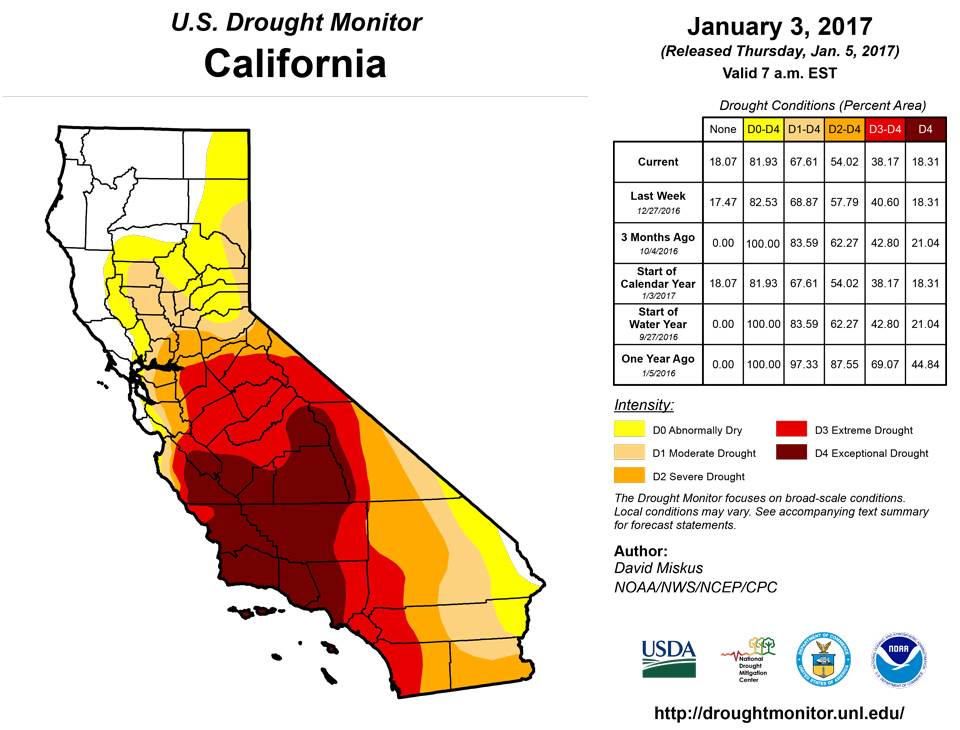
The week was rather cold and tranquil, with precipitation totals of 1.5-4 inches in the Cascades, 1-2 inches along the Oregon and northern California coasts, 1-2 inches in the Sierra Nevada, and 0.5-2.5 inches across the Southwest, including southern California and Arizona for the second consecutive week. Downtown Los Angeles recorded its wettest month (4.55 inches in December) since December 2010 (10.23 inches). Temperatures averaged below normal in the West, with anomalies of -10 to -16 deg F in eastern Oregon, southern Idaho, northern Nevada, and western Utah. As of January 3, NRCS basin average precipitation for the Water Year (since Oct. 1) was above normal in much of the West, with below-normal basins (70-99%) limited to parts of New Mexico, Colorado, and Wyoming. Basin average snow water content was also faring well, with most basins near or above normal as of Jan. 3. Some basins, however, in southern New Mexico, western Montana, northern Idaho, eastern Washington, and California were below normal. As a result of the wet start to the Water Year in southeastern California, southern Nevada, and southwestern Arizona (and supported by indices and lack of negative impacts), a 1-category improvement was made there. In southern Utah (San Juan and Kane counties), with snowpack levels above normal and indices near normal, the D0 was removed. Elsewhere, status-quo was maintained in the rest of the West after several improvements were made the previous 2 weeks.Alaska, Hawaii, and Puerto Rico
In Alaska, although most of the state is in a deep freeze that maintains status-quo, the extreme southeastern Panhandle (from the Clarence Strait southward, near Wrangell) has seen subnormal precipitation amounts the past few months, resulting in impacts to the hydropower generation due to low dam levels. As a result, D0 was added to the southern one-third of the southeastern Panhandle. In Hawaii, light to moderate showers were mainly limited to windward areas, with little or no rain on the leeward sides where the small drought areas were located. No changes were made this week, but conditions will be reassessed next week. Most of Puerto Rico saw 1-2 inches of rain during the week which kept any D0 development away.Looking Ahead
During the next 5 days (January 5-9), several Pacific storm systems laden with moisture are expected to batter California and the West, with up to 18 inches of precipitation forecast for the Sierra Nevada Mountains. Coastal areas of Oregon and the northern two-thirds of California are expecting more than 4 inches of precipitation, while the Intermountain West, northern, central, and southern Rockies, and Cascades may see 1-3 inches. Unfortunately, little or no precipitation is predicted in the middle third of the Nation (including the Plains), while a storm may develop off the Atlantic Coast. Light totals (less than 1 inch) may occur along the eastern Gulf and south Atlantic Coasts, with lake-effect snows likely in the favored Great Lakes snow belts. Temperatures across much of the lower 48 States should be well-below normal except above-normal in the Southwest.During January 10-14, the odds favor above-median precipitation in the West, northern Plains, Midwest, Northeast, and northern Alaska, with good chances for sub-median precipitation in the southern Rockies, southern half of the Plains, along the Gulf and southern Atlantic Coasts, and the southern half of Alaska. Temperatures are expected to rebound from Days 1-5 cold spell, with a favorable tilt toward above-normal readings across the southern half and eastern third of the U.S., with the cold expected to remain in the Northwest, northern Plains, and southeastern Alaska..
Author(s):
David Miskus, NOAA/NWS/NCEP/CPC
Dryness Categories
D0 ... Abnormally Dry ... used for areas showing dryness but not yet in drought, or for areas recovering from drought.Drought Intensity Categories
D1 ... Moderate DroughtD2 ... Severe Drought
D3 ... Extreme Drought
D4 ... Exceptional Drought
Drought or Dryness Types
S ... Short-Term, typically <6 months (e.g. agricultural, grasslands)L ... Long-Term, typically >6 months (e.g. hydrology, ecology)
Source: National Drought Mitigation Center

