


California and National Drought Summary for January 31, 2017
Summary
February 2, 2017 - This U.S. Drought Monitor week saw generally dry conditions across most of the conterminous U.S. during the past week. Snow showers fell across parts of the upper Midwest as well as downwind locations of the Great Lakes where moderate-to-heavy snowfall accumulations were observed. Out West, an overall dry pattern prevailed, and temperatures were well below normal with the greatest departures observed across the Great Basin and Intermountain West. Conversely, temperatures were well above normal across the Northern Plains, Upper Midwest, and New England. Overall, minor improvements were made on the map in parts of the Northeast, Midwest, Desert Southwest, and portions of California.The Northeast
On this week’s map, drought-affected areas in central and upstate New York saw improvements in areas of Moderate Drought (D1) where streamflows have been normal to above normal and precipitation has been normal to slightly above normal during the past 30 days. In Upstate New York, heavy snowfall was observed in locations downwind of Lake Ontario. In western Connecticut and southwestern Massachusetts, minor reductions in areas of Severe Drought (D2) and Extreme Drought (D3) were made in response to short-term improvements in streamflow conditions and soil moisture. The longer-term impacts to groundwater, however, remain across portions of both Connecticut and Massachusetts. In Maine, short-term improvements during the past 30–90 days as well as precipitation this week (1 to 2.5 inches of liquid) led to trimming back of areas of Moderate Drought (D1) in central portions of the state. Average temperatures were 4 to 15 degrees above normal for the week with the greatest temperature anomalies observed in Maine, New Hampshire, and Vermont. According to the National Weather Service (NWS) National Operational Hydrologic Remote Sensing Center (NOHRSC) (https://www.nohrsc.noaa.gov/nsa), 95% of the Northeast region is currently covered by snow.Mid-Atlantic
On this week’s map, only minor changes were made in north-central Pennsylvania in an area of Moderate Drought (D1) where precipitation has been above normal during the past 30–60 days and streamflows are running above normal. For the week, the region was generally dry with the exception of some lesser precipitation accumulations (less than 1 inch of liquid) in the mountains of North Carolina, Virginia, and West Virginia. For the seven-day period, average temperatures were slightly above normal.The Southeast
On this week’s map, no changes were made in the region. Overall, the region was dry, and average temperatures were above normal with the exception of Florida where temperatures were slightly below normal.The South
On this week’s map, some minor change improvements were made in the Texas Panhandle in areas of Abnormally Dry (D0) and Moderate Drought (D1) where precipitation has been above normal during the past 30–90 days. Along the Texas coast and south Texas, short-term dryness (30 days) led to slight expansion of areas of Abnormally Dry (D0) and Moderate Drought (D1). Overall, the region was dry this past week, and average temperatures were above normal across most of the region with the exception of western portions of Texas where temperatures were 2 to 4 degrees below normal.Midwest
The Midwest saw improvements on the map in west-central and southwestern Illinois in areas of Abnormally Dry (D0) and Moderate Drought (D1) as well as in Missouri in areas of Moderate Drought (D1). Despite precipitation deficits during the past 90 days across parts of Illinois and Missouri, drought-related impacts are not being observed at this time in relation to time of year. In the areas of improvement, streamflows are normal and satellite-based soil moisture measurements associated with the NASA Soil Moisture Active Passive mission (SMAP - https://smap.jpl.nasa.gov) show improvements to soil moisture during the past month. Additionally, field-based observations in Missouri show local ponds being full to nearly full. Average temperatures for the week were above normal with the greatest anomalies observed in northern portions of Minnesota and Wisconsin as well as Upper Peninsula Michigan. According to the NWS NOHRSC, 90% of the Northern Great Lakes region is covered by snow.The Plains
On this week’s map, only minor changes were made across the region. In the Black Hills region, wetter conditions during the past 30–90 days led to removal of an area of Severe Drought (D2). Natural Resource Conservation Service (NRCS) SNOTEL stations in the Black Hills are reporting normal to near-normal snow water equivalent (SWE) with the North Rapid Creek SNOTEL at 107% of the official median and the Blind Park SNOTEL at 96% of median. In western Nebraska, a small area of Abnormally Dry (D0) was reduced in response to above- average precipitation during the past 30–90 days. In Oklahoma, dry conditions and above- normal, fine-fuel loading led the National Interagency Fire Center to issue a Fuels and Fire Behavior Advisory (effective February 1–14) to warn of critical wildland fuel conditions that increase the potential for extreme fire danger. Overall, the region was dry during the past week with the exception of some low precipitation accumulations, generally less than 1 inch, across parts of Nebraska and South Dakota. Average temperatures were slightly above normal in the western extent of the region while eastern portions were well above normal.The West
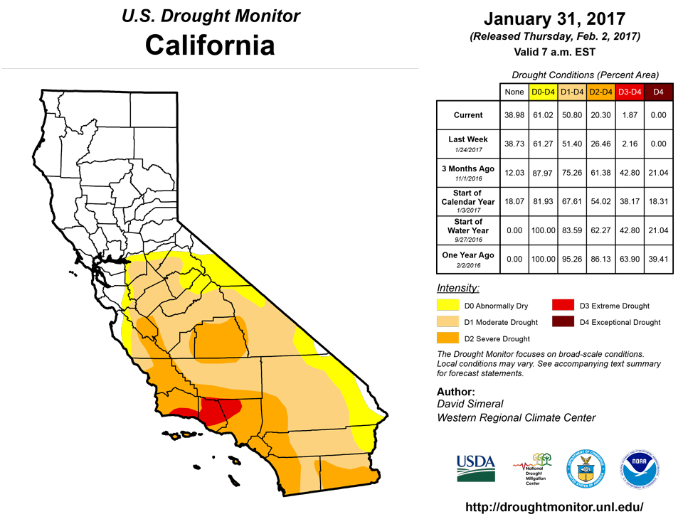
During the past week, most of the West was very dry and temperatures were well below normal with the exception of the plains of eastern Colorado and Montana. On the map, one-category improvements were made in areas of Moderate Drought (D1) and Severe Drought (D2) along the central Coast of California and in portions of the San Joaquin Valley where recent storm events during the past 30 days have improved overall conditions. Streamflows across the state are running normal to above normal. According to the California Department of Water Resources, the snowpack (statewide) is currently 108% of the April 1 average and 174% of normal for the date (February 1). Despite improvements across much of the state, the longer-term impacts of the drought are still being observed in relation to groundwater supplies in various California locations. In southern California, the San Diego County Water Authority issued a statement declaring that drought conditions in San Diego County have ended. It should be noted, however, that the state of California is still officially in drought under Governor Brown’s drought declaration (1/17/14). Elsewhere in the region, improvements were made in an area of Severe Drought (D2) in southwestern Arizona as well as in east-central Arizona along the Mogollon Rim and northeastern Arizona. In Colorado and Wyoming, minor reductions in areas of Abnormally Dry (D0) were made on the map in response to normal to above-normal snowpack conditions.Hawaii, Alaska, and Puerto Rico
On this week’s map, no changes were made in Alaska, the Hawaiian Islands, or Puerto Rico. In Alaska, average temperature were well above normal statewide with the greatest anomalies (12 to 20 degrees above average) observed in western Alaska. NRCS SNOTEL stations on the Kenai Peninsula, Chugach Mountains, and Wrangell Mountains are all reporting below-normal snowpack conditions.Looking Ahead
The NWS WPC 7-Day Quantitative Precipitation Forecast (QPF) calls for moderate-to-heavy rainfall in the lower elevations of central and northern California as well as Oregon while significant mountain snowfall accumulations are forecast for the higher elevations of the Sierra, Cascades of Oregon and Washington, and the northern Rockies of Idaho and western Wyoming. Moving eastward, lesser precipitation accumulations (less than 1.5 inches) are forecast for northern portions of Alabama and Mississippi, Kentucky, and Tennessee. Conversely, dry conditions are expected across the southwestern U.S. and western portions of the Southern Plains and Texas. The CPC 6–10 day outlooks call for a high probability of above-normal temperatures across the entire conterminous U.S., with the exception of the Northern Plains and Pacific Northwest where there is a high probability of below-normal temperatures. Below-normal precipitation is forecast for the southwestern U.S., Central Rockies, and the Southern Plains. Above-normal precipitation is expected in the Eastern tier as well as the northern portion of the western U.S.Author(s):
David Simeral, Western Regional Climate Center
Dryness Categories
D0 ... Abnormally Dry ... used for areas showing dryness but not yet in drought, or for areas recovering from drought.Drought Intensity Categories
D1 ... Moderate DroughtD2 ... Severe Drought
D3 ... Extreme Drought
D4 ... Exceptional Drought
Drought or Dryness Types
S ... Short-Term, typically <6 months (e.g. agricultural, grasslands)L ... Long-Term, typically >6 months (e.g. hydrology, ecology)
Source: National Drought Mitigation Center
