


California and National Drought Summary for February 7, 2017
Summary
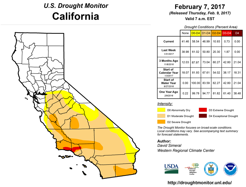
February 9, 2017 - This U.S. Drought Monitor week saw a very active pattern in parts of the western U.S. as a series of Pacific storms brought significant rain to coastal areas of central and northern California, Oregon, and Washington while heavy snows blanketed higher elevations of the Sierra, Cascades, and northern Rockies. Continued snowfall this week across the Sierra is making a positive impact on the overall drought situation where the snowpack statewide is 176% of normal according to the California Cooperative Snow Surveys. Most of the major reservoirs in California are currently above historical averages. Some lingering hydrologic impacts (low reservoir levels and below-normal groundwater levels) are still present in portions of the central Coast, southern California, San Joaquin Valley, and the western foothills of the Sierra despite abundant precipitation during the past several months. Elsewhere in the West, mountain snowpack levels are normal to above normal across the Great Basin, southern Cascades, Wasatch, as well as central and southern Rockies. In the southern Plains and portions of the South, overall dry conditions have persisted, especially across Arkansas and Oklahoma. During the past week, temperatures were above normal across most of the conterminous U.S. with the exception of the northern Plains and much of the Pacific Northwest where temperatures were 5 to 20 degrees below normal with the greatest departures observed across Montana.The Northeast
On this week’s map, drought-affected areas in central New York saw minor improvement in an area of Moderate Drought (D1) in the eastern portion of the Finger Lakes region where streamflows are normal and precipitation during the past six months has been near- to-above normal. Elsewhere, minor improvements were made in southwestern Massachusetts and western Connecticut in an area of Extreme Drought (D3) where some limited recovery has taken place in recent months in relation to the longer-term hydrologic impacts (reservoirs, wells). During the past week, the region was generally dry with the exception of some lake-effect snowfall activity downwind of Lake Ontario. Average temperatures across the region were a mixture of below- and above-normal temperatures with northern Maine 4 to 6 degrees below normal while far eastern portions of New York, New Hampshire, and Vermont were 2 to 6 degrees above normal.Mid-Atlantic
On this week’s map, the Mid-Atlantic remained status quo. For the week, the region was generally dry with the exception of some minor precipitation accumulations (generally less than one half inch of liquid) in western Pennsylvania as well as parts of West Virginia and North Carolina. For the seven-day period, average temperatures were slightly above normal across most of the region with the exception of portions of Pennsylvania and West Virginia where temperatures were a few degrees below normal.The Southeast
On this week’s map, no changes were made in the region. Overall, the region was generally dry with the exception of central portions of Alabama where about an inch of rain was observed during the past week. Overall, average temperatures were above normal with the greatest anomalies (2 to 6 degrees) observed in Alabama, Georgia, and South Carolina.The South
On this week’s map, some minor changes were made in northwestern Louisiana where short-term precipitation deficits (past 60 days), low streamflows, and dry soils led to expansion of an area of Abnormally Dry (D0). In northwestern Arkansas, continued dry conditions, low streamflows, and reservoir levels led to expansion of areas of Abnormally Dry (D0), Moderate Drought (D1), and Severe Drought (D2). According to the U.S Army Corp of Engineers, five area reservoirs (Beaver, Bull Shoals, Greers Ferry, Norfolk, and Table Rock) are currently 5 to 10 feet below normal levels. In Texas, dry conditions prevailed across most of the state with the exception of extreme southern portions where about an inch of precipitation fell. Some minor degradations were made on the map in portions of the Panhandle, east Texas, and along the Gulf Coast. Overall, the region was generally dry this past week except in southern Arkansas and northern Mississippi where 1 to 2 inches of rainfall accumulation were observed. Average temperatures were above normal across most of the region with the greatest anomalies (6 to 10 degrees) in the eastern half of Texas, Louisiana, and southern Mississippi.Midwest
On this week’s map, no changes were made. Average temperatures for the week were above normal with the greatest anomalies observed in Iowa, central Missouri, and southern Minnesota where temperatures were 4 to 8 degrees above normal while extreme northern Minnesota, Wisconsin, and Upper Peninsula Michigan were below normal. During the past week, the region was generally dry with some light precipitation accumulations observed in northern portions of Minnesota and Wisconsin, Ohio, and the Upper Peninsula Michigan.The Plains
On this week’s map, only minor changes were made across the region in the Panhandle of Nebraska in an area of Abnormally Dry (D0) where precipitation during the past 30 to 90 days and increased soil moisture led to improvements. Overall, the region was dry during the past week. Average temperatures were well below normal (5 to 15 degrees) in northern portions while southern portions were above normal.The West
During the past week, a series of storms bringing widespread rain and snow showers impacted the states along the Pacific Coast and northern Rockies. In California, the cumulative effect of several months of abundant precipitation has significantly improved drought conditions across the state. Nearly all of California’s major reservoirs are currently above historical average levels with the state’s two largest reservoirs, Oroville and Shasta, currently at 126% and 124%, respectively. To date, the statewide percent of normal snow water equivalent sits at an impressive 176%, according to the California Cooperative Snow Surveys. Heavy snowfall this week in the Sierra led to improvements on the map in areas of Abnormally Dry (D0), Moderate Drought (D1), and Severe Drought (D2). Along the central Coast, continued heavy rains in the Santa Lucia Range led to improvements in areas of Abnormally Dry (D0), Moderate Drought (D1), and Severe Drought (D2) where streamflows and soil moisture levels are above normal. Along the southern California coast, one-category improvements were made in areas of Severe Drought (D2) where a wide variety of drought indicators (Palmer Drought Severity Index, Standardized Precipitation Index, streamflow activity, soil moisture levels, drought impact reports) at various timescales (30 days to 2 years) led to improvements in an area extending from southern Ventura County to San Diego County. In Santa Barbara and northern Ventura counties, an area of Extreme Drought (D3) has remained in place as local reservoirs and groundwater levels have been lagging behind other indicators as a result of the cumulative effect of significant long-term precipitation deficits. The Municipal Water District of Orange County (as of February 6, 2017) declared an end to the drought emergency. Elsewhere in the region, improvements were made in areas of Abnormally Dry (D0) and Moderate Drought (D1) in western Nevada. In Utah, areas of Abnormally Dry (D0) were reduced in western and northern portions in response to improvements in soil moisture and above-normal precipitation amounts during the past four-month period. The remaining area of Abnormally Dry (D0) in Utah covers areas in which below-normal reservoir levels persist.Hawaii, Alaska, and Puerto Rico
On this week’s map, no changes were made in Alaska, the Hawaiian Islands, or Puerto Rico. In Alaska, average temperatures were well above normal in central and northern portions of the state with the Barrow Airport reporting 25 degrees above normal for the week. Statewide, Alaska was dry overall during the past week. In the Hawaiian Islands, overall dry conditions prevailed with temperatures hovering within a few degrees of normal.Looking Ahead
The NWS WPC 7-Day Quantitative Precipitation Forecast (QPF) calls for moderate-to-heavy precipitation accumulations in northern California as well as western Oregon, western Washington, northern Idaho, and northwestern Wyoming. Moving eastward, lesser precipitation accumulations (less than 1.5 inches) are forecast for Texas, northern portions of the Mid-Atlantic, and eastern portions of the Midwest. Some heavier precipitation amounts (2 to 3 inches) are forecast for New England for the seven-day period. The CPC 6–10 day outlooks call for a high probability of above-normal temperatures across the entire conterminous U.S., with the exception of New England where below-normal temperatures are forecast to prevail. Below-normal precipitation is forecast for the Intermountain West, central and northern Plains, and the Midwest while above-normal precipitation is expected along the West Coast, South, and New England.Author(s):
David Simeral, Western Regional Climate Center
Dryness Categories
D0 ... Abnormally Dry ... used for areas showing dryness but not yet in drought, or for areas recovering from drought.Drought Intensity Categories
D1 ... Moderate DroughtD2 ... Severe Drought
D3 ... Extreme Drought
D4 ... Exceptional Drought
Drought or Dryness Types
S ... Short-Term, typically <6 months (e.g. agricultural, grasslands)L ... Long-Term, typically >6 months (e.g. hydrology, ecology)
Source: National Drought Mitigation Center
