


Below normal number of offshore wind events this spring.
Slightly below normal precipitation, slightly above normal temperatures through June.
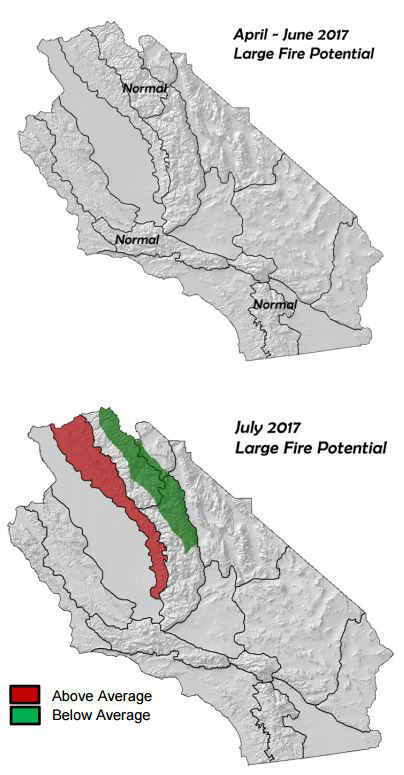
Large fire potential near normal through the spring. May be a substantial increase in grass fire activity across lower elevation areas late spring/early summer.
Summer monsoon rains may be below normal again this summer.
April 3, 2017 - Weather Discussion: After a wet, and in some cases record-breaking, winter rainy season, the storm track shifted northward at the beginning of March. This caused most of the
 noteworthy storms to shift away from much of Central California and all of Southern California. Once this occurred, rainfall decreased to below normal over most of the district. In fact, some areas from Los Angeles County northward into the central Mojave Desert saw about the same amount of rain in March 2017 as the previous dry years. Fortunately, due to the previous very wet months, seasonal precipitation tallied since October 1st 2016 is still 100-200% above normal over Southern California and over 300% above normal over portions of the Sierras.
 April 1st traditionally marks the point in the year when precipitation begins to wind down for the season. This year, the winter rains seem to be following the typical pattern of migrating northward. Southern California will likely only see trivial amounts of precipitation this spring (under 0.50” with any individual storm) while the Central part of the state sees rain decrease from south to north in April and May. Peak snowpack has likely been achieved in the Sierra high country. Sunny days and seasonally warm temperatures should send a great amount of snowmelt into waterways and reservoirs. This may lead to some flooding concerns this spring should the weather turn very warm for an extended period of time.
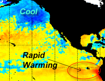
Across the Pacific, the trend of cooling sea surface temperatures (SST) in the Gulf of Alaska and warming along the equator continued during the past month (see below). At the current time, the Niño Region 1+2 near the South American coast is over 2.5° C above normal. This burst of warming may be responsible for the intense flooding which occurred in Peru last month. While the rate of warming along the equator may be showing signs of leveling off, most longterm models are predicting a positive ENSO signal for the summer into the fall.
Figure 1: Current SST anomalies, Eastern Pacific
The continuation (and perhaps intensification) of the above normal SST pattern along with the expected El Niño this summer would suggest that the pattern of troughing in the Gulf of Alaska and Pacific Northwest may continue well into summer. This may keep the district in a prevailing northwesterly to southwesterly flow, depending on how far away from the shore the trough axis lies (Figure 2, below). Upstream ridging may be expected across the Southwest and Central Rockies.
Figure 2: Possible long wave pattern this summer
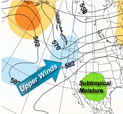
If the upper level pattern favors the current SW/NW flow this summer, subtropical monsoonal flow may be inhibited. The import of subtropical moisture typically requires easterly flow to reach California. Periods of winds aloft favorable to the advection of subtropical moisture may be hard to come by this summer as was the case during last summer. 2016 saw one of the lowest number of lightning strikes across the district in years. This summer may also be well below normal in terms of number and coverage of summer thunderstorms.
The Pacific Decadal Oscillation (PDO) remains positive at the current time, although the index has been trending closer to zero during recent months. But it should remain above normal or close to zero this spring. Local studies have shown a correlation between negative PDO’s and an increased rate of offshore wind events. Therefore, offshore wind events are expected to occur at a below normal rate the rest of the spring. Climatologically, offshore wind events are rare after May 31st and no such wind events are likely in late spring or summer this year.
Temperatures should average near normal through the spring into summer. However, due to active jet and an amplified pattern expected over the Pacific, there may be a considerable variation in observed temperatures this spring. So far this spring, changes in the weather have occurred in a roughly 72-96 hour period with few prolonged periods of ridges. This stands in contrast to the past several springs when a strong blocking pattern kept conditions unceasing warm and dry. In other words, expect a bit more temperature fluctuation this spring with very warm periods interspersed with frequent, but brief, cooler patterns.
Fuels and Drought Outlook
At the current time, live fine fuels such as seasonal grasses are curing across much of Southern California. Exposed south aspects have seen significant curing,
 especially from Los Angeles County southward where less precipitation fell during the past 30 days. However, further north, only the sunniest south aspects have seen much curing as of March 31st.
 April is often the month when seasonal grasses cure quickly. The sheer height and density of this year’s grass crop may keep fuels greener for a longer period of time than usual, but by the start of May, most areas of Central California away from the coast will see curing of grasses well underway. Southern California will probably see these grasses cured out in all but the shadiest, most sheltered places by the middle of May.
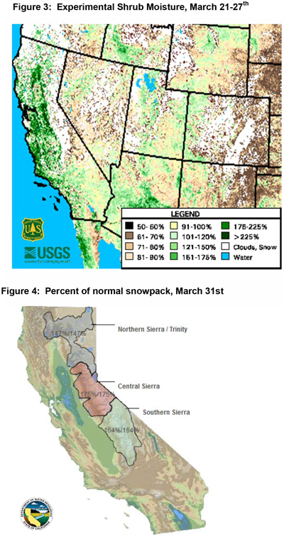
Shrubs have likely seen live fuel moisture peak by now as the top few inches of soils are beginning to become quite dry from Fresno County southward. But the wet winter will insure live fuel moisture will remain well above normal for several more weeks to come in native brush and shrubs. (Figure 3, top left).
The legacy of a far above normal snowpack will be felt well into summer this year as meltout will likely occur several weeks later than usual. Even after all of the snow is gone from vegetated areas, lingering subsoil moisture should keep fuel moisture high through July. A similarly deep snowpack during the winter of 2010-2011 kept high elevation fuel moisture well above normal for most of the summer. Several fires which began at lower elevations that year exhibited much less active fire behavior above 8,500’ or so.
Large fire potential is expected to remain near normal through the spring, but once fine fuels dry out, there will likely be a spike in grass fire activity. The Sierra Foothills, in particular, may see above normal fire activity this summer due to a heavy grass crop interfacing with a high concentration of bug-killed trees. Fewer thunderstorms may keep fuels from recovering much moisture in coming months.
At the opposite end of things, large fire potential will remain below normal through much of the summer from 9,000 feet and above. Fires which begin in the foothills stand a good chance of growing rapidly during hot or windy periods, but some of the heavy timber at higher elevations may not become involved until the fall, if at all.
Source: Predictive Services
