


California and National Drought Summary for April 4, 2017
Summary
April 7, 2017 - During the past 7-days, an active weather pattern ensued across the contiguous United States. Larger, contiguous areas of heavy precipitation (greater than 2 inches) were observed from Kansas east-northeastward across the Midwest to Lower Michigan, the Lower Mississippi Valley and Gulf Coast area, parts of the Appalachians and adjacent foothills, portions of the Northeast and mid-Atlantic, and the Pacific Northwest. Light precipitation (less than 0.5-inch) was observed across most of California and the Southwest, leeward slopes of the Cascades in Washington and Oregon, the north-central CONUS, eastern Maine, and central and southern Florida. Moderate precipitation (0.5-2.0 inches) was generally reported elsewhere. During the past week, there have been numerous severe weather reports, primarily across the southeastern quadrant of the CONUS, but also overspreading the Midwest and Ohio Valley. After some consideration, it was decided that a few small changes should be made across southern and eastern Georgia and adjacent counties in South Carolina, which have seen increasing dryness and well above-normal temperatures this past week. Once the storm currently influencing this area departs, there will be more time available for a more realistic reassessment of conditions next week.The Northeast and Mid-Atlantic
Moderate to heavy precipitation (generally 0.5-4.0 inches, locally greater) fell over most of this area during the past 7-days. This resulted in significant one-category improvements to the drought depiction in areas where precipitation amounts generally exceeded 2 inches. The bulk of the improvements were made in southern and central New England, northern New Jersey, Maryland, and Virginia. Though the recent rainfall virtually wiped out the short-term drought in this region of the country, there are lingering long-term factors to also consider. One factor is precipitation deficits of 4-12 inches during the past 180-days over the coastal plain (precipitation surpluses were generally observed over the higher terrain of the Northeast and Mid-Atlantic). Another factor to consider is significantly reduced groundwater availability. With the start of the growing season and the emergence of vegetation, the groundwater recharge season is ending. One-category improvements in the drought depiction were also rendered to the Washington, D.C. and Baltimore Metro areas. The impact label “SL” (indicating significant impacts from both short- and long-term considerations) was changed to “L” to emphasize the long-term nature of the drought.Southeast
During the past 7-days, 2-5 inches of rain across (primarily) western Alabama resulted in one-category improvements to portions of this area, and to several adjacent counties in Mississippi.In northwestern Georgia, a one-class improvement was rendered to the drought depiction across the Counties of Walker, Catoosa, Whitfield, Murray, Chattooga, and Floyd. In southern and eastern Georgia, and adjacent counties of South Carolina, increasing dryness and well above-average temperatures (by 6-12 degrees F) warranted the introduction of moderate drought (D1) conditions. The affected Counties include Decatur, Mitchell, Colquitt, and northern Grady (southern Georgia), Screven, Effingham, and Chatham (eastern Georgia), and southern Allendale, Hampton, Jasper, and Beaufort (South Carolina). These changes were also based on 60-day Percent of Normal Precipitation (PNP), and 90-day Standardized Precipitation Index (SPI) blends. In Colquitt County (southern Georgia),there were reports of corn planting nearing completion, cabbage crops progressing quickly, and growers are preparing to start planting cotton and peanut crop. In addition, pastures and hayfields are struggling due to the lack of moisture, and the wheat crop is considered fair at best. With a low pressure system currently moving across the Southeast, it was decided to hold off on any additional degradation this week, until the storm’s effects/impacts can be determined.
According to the Advanced Hydrologic Prediction Service (AHPS), excessive rains (2-10 inches or greater) fell over northern Florida during the past week. This warranted a one-class improvement for nearly all of this area (including the Panhandle). In contrast, across far southern Florida, the area of D0 crept slightly towards the coast, signifying a slight expansion of abnormal dryness.
In North Carolina, heavy precipitation (generally 2-5 inches, locally greater) fell across the western mountains, and 1-3 inch totals were observed over much of the coastal plain. In-between these two areas, the North Carolina Piedmont region received moderate precipitation (0.5-1.5 inches). Revisions across portions of the state represented a balance between short-term and long-term drought indicators. Moderate drought (D1) was removed this week from the far southern coastal plain. In the western mountains, the recent precipitation resulted in a one-category improvement for some areas, though longer-term drought indicators still depict abnormally dry conditions.
The Lower Mississippi Delta
Recent rainfall (4-10 inches during the past week) resulted in the trimming away of D0 from Warren and Hinds Counties in western Mississippi (Vicksburg to Jackson area), and a trimming away of the southern edge of the moderate drought area (D1) in eastern Mississippi. Additional improvements are likely to be made in this general region next week.The Midwest
Weekly precipitation amounts ranging from about 2-4 inches resulted in a one-class improvement across most of Missouri, including the St. Louis area, with the exception of the far south and southeast parts of the state. The abnormal dryness (D0) in adjacent west-central Illinois was removed, due to comparable rainfall totals. In south-central Iowa, where moist subsoil moisture was noted, a one-category improvement was made to the depiction.The Plains
Widespread one-category improvements were made to the depiction across Texas, Oklahoma, and Kansas, where heavy precipitation (mostly 2-5 inches) was reported by the Applied Climate Information Service (ACIS) in the past week. In Texas, the city of Del Rio in Val Verde County received 5.07 inches of rain on April 2nd, which is a record for the date and nearly one-third of their annual rainfall. In addition, all severe drought (D2) areas were removed from the Lone Star state, as short-term wetness was minimizing impacts. In Oklahoma, Interstate 44 served as a surprisingly good demarcation line between heavy precipitation to its north and west, and light precipitation to its south and east. The extreme drought (D3) area was reduced to severe drought (D2) over the Oklahoma Panhandle. In a small area encompassing portions of Osage, Pawnee, and Creek Counties, 4.0-5.5 inches of rain fell, justifying a rare two-class improvement to the U.S. Drought Monitor. In eastern Oklahoma and adjacent portions of western Arkansas, the three areas of D2 drought were combined into a single entity. In Kansas, a one-category improvement was made across practically the entire state, with the exception of the far northwest, which has been drier. In the southeast Nebraska Counties of Gage, Pawnee and Richardson, abnormally dry conditions (D0) were eliminated. Moderate drought (D1) was removed from the far northern counties of the Nebraska Panhandle, including Sioux, Dawes, and Sheridan. In northeastern New Mexico, moderate precipitation (0.5-2.0 inches) warranted a one-category improvement in the drought depiction, with the exception of Union County, which mostly missed out on recent precipitation events. In eastern Colorado, several small-scale one-category improvements were rendered to the depiction. No changes to the depiction were made in the northern Plains this week.The West
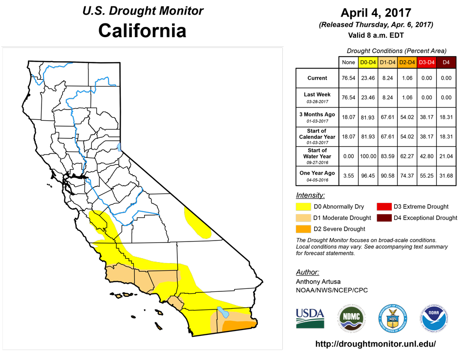
In California, reservoirs are mostly above-average (Percent of Average Reservoir Storage values mostly between 100-170 percent), though there are a few exceptions. One of the more notable exceptions being tracked is the Cachuma Reservoir northwest of Santa Barbara, CA, which is reporting a Percent of Average Reservoir Storage of 57-percent. No changes to the USDM map were deemed necessary in California, Nevada, or Arizona.Alaska, Hawaii, and Puerto Rico
In Hawaii, there has been some trade wind shower activity recently, but for the most part, conditions are dry overall with a persistent, stable air mass over the area. The last notable rain-producing system occurred in early March, though this precipitation did not reach the Big Island. The recent lack of significant trade wind shower activity has put windward slopes of all the islands under increasing rainfall deficits over the past month. Alterations made in Hawaii this week were in the form of deteriorations. Abnormal dryness (D0) was introduced to the northeast two-thirds of both Kauai and Oahu, expanded over the remainder of Molokai, and introduced to the northwest one-third of Lanai. D0 was also introduced to the windward slopes of Haleakala. No changes were made to the Big Island this week, where the return of some trade wind shower activity has at least offset additional degradation along the windward slopes. The primary drought impacts for the Big Island continue to be from the west side. No changes were made to the depiction in Alaska this week, and Puerto Rico continues to be drought-free.Looking Ahead
During the next five days (April 6-10), the Weather Prediction Center (WPC) precipitation forecast calls for moderate precipitation (0.5-1.5 inches) to reach perhaps as far south as Santa Barbara, CA. The Northern Plains is predicted to receive close to a half-inch of precipitation during this 5-day period, which should at least offset any additional deterioration. Light precipitation (less than 0.5-inch) expected over the Central and Southern Plains offers little in the way of additional drought improvements. One to two inches of rain anticipated for the Northeast and Mid-Atlantic Coastal Plain provides improved prospects for additional drought relief in that region, as does moderate to heavy rainfall (0.5-4.0) inches across the Southeast, with the possible exception of Florida.For the ensuing five-day period (April 11-15), there are elevated odds for above-median precipitation across the south-central CONUS, northern California, the Pacific Northwest, the northern Rockies, and parts of the Upper Mississippi Valley. There are elevated odds for below-median precipitation across the Southeast, and in a band stretching from the southern Sierras of California eastward across much of the Rockies and Plains, the north-central Mississippi Valley, the southern Great Lakes region, and the Northeast. Below-median precipitation is also favored for most of Alaska, south of the Brooks Range.
Author(s):
Anthony Artusa, NOAA/NWS/NCEP/CPC
Dryness Categories
D0 ... Abnormally Dry ... used for areas showing dryness but not yet in drought, or for areas recovering from drought.Drought Intensity Categories
D1 ... Moderate DroughtD2 ... Severe Drought
D3 ... Extreme Drought
D4 ... Exceptional Drought
Drought or Dryness Types
S ... Short-Term, typically <6 months (e.g. agricultural, grasslands)L ... Long-Term, typically >6 months (e.g. hydrology, ecology)
Source: National Drought Mitigation Center
