


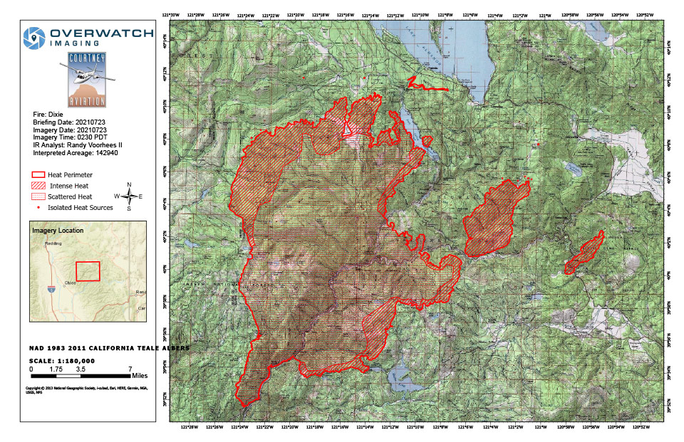
Dixie Fire Infrared Topo Map for Friday, July 23, 2021
Note: 960 Pixels Wide
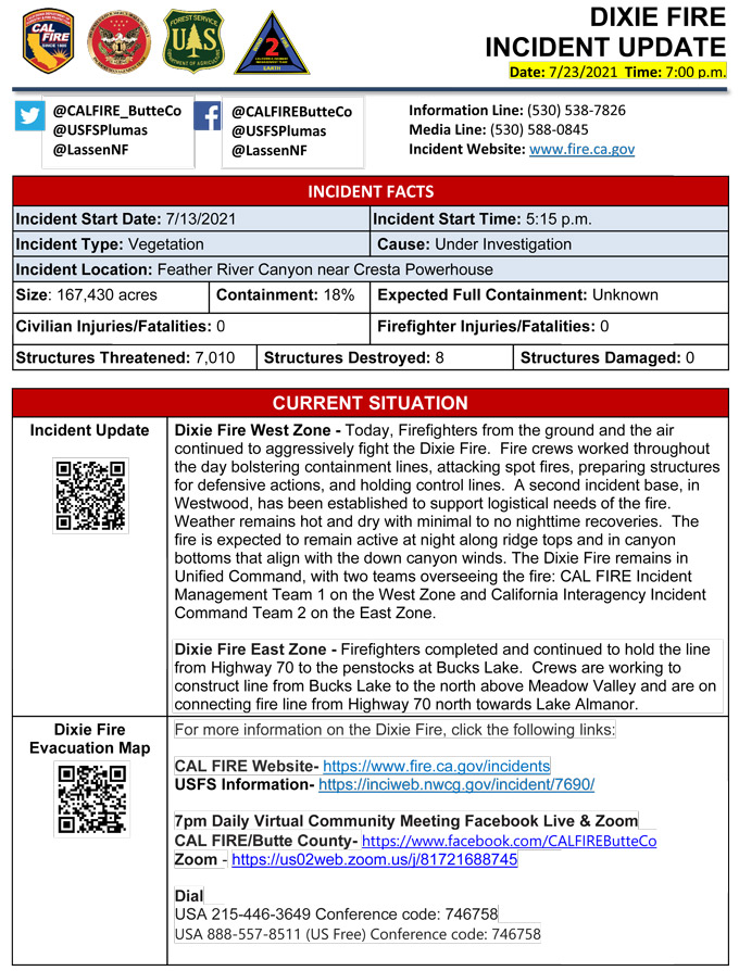
Evening Update: CAL FIRE reports the Dixie Fire in Butte and Plumas Counties is at 167,430 Acres with 18% Containment.
Update: 3:10 P.M. The Butte County Sheriff's Office (BCSO) is UPGRADING the EVACUATION WARNING to an EVACUATION ORDER for the Butte Meadows area due to the Dixie Fire.
And
Plumas County Evacuation Updates 7/23/21 100 pm (pdf 137 kb)
Update 2:38 P.M. An Evacuation Warning has been issued for East Quincy. This warning now includes all of Quincy from Hwy 70 near Massack and everything west toward Meadow Valley. This includes Chandler Rd and Quincy-La Porte Rd from Hwy 70 to Thompson Creek. tinyurl.com/vcr4f62e
Update 2:00 P.M.
Lassen and Plumas National Forests, July 23, 2021 — Yesterday, the Dixie Fire saw extreme fire behavior and new evacuations. Today will continue to be hot and breezy with a relative humidity of less than 20% and similar fire behavior with the potential of two to three miles of growth. The Dixie Fire remains in Unified Command, but two teams oversee the fire: CAL FIRE Team 1 on the West Zone and California Interagency Incident Command Team 2 on the East Zone.
On the East Zone, the line was completed from Highway 70 to the penstocks at Bucks Lake, and crews will hold this line today. They will also be working on line from Bucks Lake to the north above Meadow Valley. Elsewhere on the East Zone, crews will be working at connecting line from Highway 70 north towards Lake Almanor and improving structure protection. On the West Zone, the fire crossed the Humbug Road line and moved across the northwest lines. Firefighters will be scouting new line locations on the north and northwest sides of the fire. Resources in the southern portion of the fire are patrolling and mopping up. A new fire started yesterday afternoon in Butterfly Valley north of Keddie, and the cause is currently under investigation. The Fly Fire grew to over 1,600 acres and is being managed as part of the East Zone. It is the number one priority for the East Zone.
Due to the extreme drought conditions that persist throughout the area, residents and visitors are asked to use caution when doing yard work, towing vehicles or trailers, or other outdoor activities that involve flammable heat sources. Forest visitors are reminded that fire restrictions remain in effect throughout the Lassen and Plumas National Forests.
For more information, visit https://tinyurl.com/x8wh9jvt and https://tinyurl.com/476p6p2k.Current Forest Closure information can be found at: https://inciweb.nwcg.gov/incident/closures/7690/Current Evacuation information can be found at: https://tinyurl.com/4nm69873Current Road Closures: https://roads.dot.ca.gov/roadscell.php
Basic Information
| Current as of | 7/23/2021, 10:39:28 AM |
| Incident Type | Wildfire |
| Cause | Under Investigation |
| Date of Origin | Tuesday July 13th, 2021 approx. 05:15 PM |
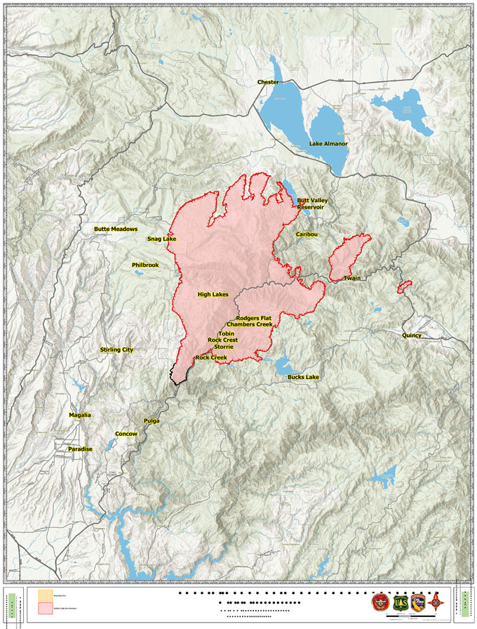
| Location | Feather River Canyon near Cresta Powerhouse |
| Incident Commander | Lassen National Forest Plumas National Forest Cal Fire Incident Management Team 1 |
| Coordinates | 39.819 latitude, -121.419 longitude |
Current Situation
| Total Personnel | 4,005 |
| Size | 142,940 Acres |
| Percent of Perimeter Contained | 18% |
| Estimated Containment Date | Saturday July 31st, 2021 approx. 12:00 AM |
| Fuels Involved |
Timber (Grass and Understory) Chaparral (6 feet) |
| Significant Events |
Active Uphill Runs Flanking Long-range Spotting Fire remained active overnight with active surface fire and multiple tree torching with long range spotting and rollout. |
Outlook
| Planned Actions |
Construct direct and indirect line to secure fire perimeter. Construct contingency lines. Provide structure defense in communities at risk. |
| Projected Incident Activity |
Fire is going to continue to move North and North East mainly in divisions P, Q, R, S and W with the potential for 2-3 miles of new growth. Spot in Division U will continue to burn up the canyon towards town of Greenville. |
| Remarks |
California Interagency Incident management team 2 (CIIMT 2) shadowing today and will assume command of the East Zone on 7/23/2021 at 0600. |
Current Weather
| Weather Concerns |
Conditions will become hotter and drier for Fri and Sat as the Great Basin Ridge strengthens and builds west into the area. Min RHs will drop into the upper single digits with little to no overnight recovery. The breezy SW afternoon winds will weaken slightly Fri and Sat with the down canyon NE wind becoming more enhanced. The leading edge of a monsoonal moisture push will begin to approach the area on Sun increasing the potential for large pyro cumulus or cumulonimbus development over the fire area Sun afternoon and evening. Thunderstorm chances will increase Mon through Wed as monsoonal moisture surges push across the area. Observed Weather Conditions 7/22/21 Thu afternoon Wind: SW 10-15 mph gusts 20-25 mph Max Temp: Mid 90s 2000-3000 ft valleys to mid 70s 6000-7000 ft ridges Min RH: 8-14% Forecasted Weather for Next Operational Period 7/23 Fri Day Shift Wind: SW 8-11 mph gusts 15 to 20 mph Max Temp: Upper 90s 2000-3000 ft valleys to upper 70s 6000-7000 ft ridges Min RH: 7-9% Forecasted Weather for Next Operational Period 7/23-24 Fri Night Shift Wind: NE 15-20 mph gusts up to 30 mph Min Temp: Upper 60s to low 70s Max RH: Around 15 |
Update: Per InciWeb 11:00 A.M.
Dixie Fire West Zone: The Dixie Fire remained active overnight with active surface fire and multiple tree torching with long range spotting and rollout. The fire is going to continue to move North and Northeast with the potential for 2-3 miles of new growth. The fire is burning in a remote area with limited access, extended travel times and steep terrain which hampers controlefforts. Fire will continue to rapidly expand causing a need for the critical resources to control the fires spread.
Dixie Fire East Zone: Yesterday crews made good progress along the southeast edge of the Dixie Fire toward Bucks Lake. Today, if conditions are favorable a firing operation is planned to tie the existing fireline into the west shoreline. The intent of this operation is to keep the fire north of Bucks Lake. Firefighters will also address the Fly Fire, a new start just north of Keddie.The Fly Fire ignited yesterday evening in Butterfly Valley and burned quickly to the northeast across Hwy 89/70, growing to well over 1,650 acres. The cause is under investigation. The extreme fire behavior and long range spotting of both fires prompted several additional evacuation orders and warnings. The fires are expected to continue moving to the northeast today. Fire behavior is expected to remain extreme.
Update 8:43 A.M. Per Lassen N.F. Due to fire activity, a MANDATORY EVACUATION ORDER has been issued for a portion of Chandler Rd from Hwy 70 at Chandler Rd west, to Oakland Camp. Please leave the area immediately! Evacuate eastbound to 59 Bell Lane in Quincy.
July 23, 2021 - Per CAL FIRE: DIxie Fire off above the Cresta Dam, Feather River Canyon in Butte County is 142,940acres and 18% contained.
Click here for: Thursday, July 22, 2021 Updates
