


Evening Video Update: Dixie Fire East Zone Operations Evening Briefing Video for Wednesday, July 28, 2021
Evening Update Per CAL FIRE: Dixie Fire in Butte County and Plumas County is 220,012 acres and 23% contained for Wednesday evening.
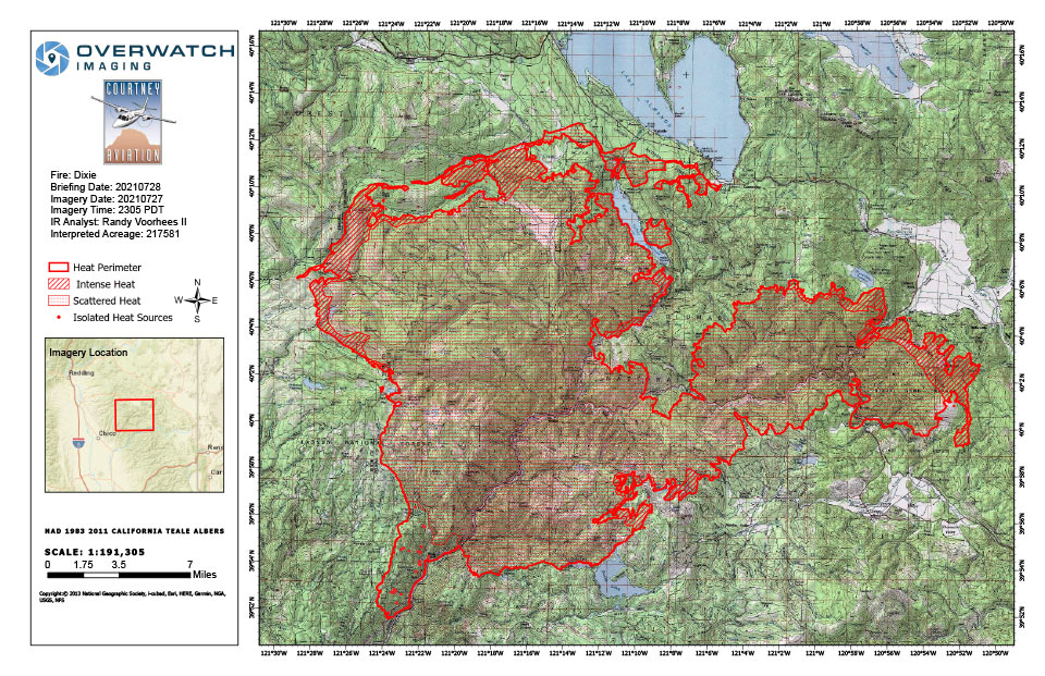
Dixie Fire Infrared Map for Wednesday, July 28, 2021
Note: 960 Pixels Wide
Flight Notes:
Fire continues to grow in most directions. No heat observed on back side of burnout operations.
Scattered heat remains through out most of the fire. Other than growth to the east and along the burn operations most of the fire had little growth today.
Update: Dixie Fire East Zone Operations Morning Briefing Video for Wednesday, July 28, 2021
Update: Smoke/Air Quality Outlook for the Dixie Fire in the Eastern Sierra for Wednesday, July 28
July 28, 2021 - Per CAL FIRE: Dixie Fire in Butte County and Plumas County is 217,581 acres and 23% contained for Wednesday morning.
Update 7:54 A.M. CAL FIRE
'Click' here to view full PDF
Basic Information
| Current as of | 7/28/2021, 6:45:37 AM |
| Incident Type | Wildfire |
| Cause | Under Investigation |
| Date of Origin | Tuesday July 13th, 2021 approx. 05:15 PM |
| Location | Feather River Canyon near Cresta Powerhouse |
| Incident Commander | CALFIRE Incident Management Team 1/California Interagency Incident Management Team 2 |
| Incident Description | Wildfire |
| Coordinates | 39.819 latitude, -121.419 longitude |
Current Situation
| Total Personnel | 5,306 |
| Size | 217,581 Acres |
| Percent of Perimeter Contained | 23% |
| Estimated Containment Date | Friday August 13th, 2021 approx. 12:00 AM |
| Fuels Involved |
Timber (Grass and Understory) Chaparral (6 feet) |
| Significant Events |
Minimal Flanking Backing Creeping Minimal fire activity overnight with higher RH slowed and stopped burning operations. Fire continued to creep and back. |
Outlook
| Planned Actions |
Construct direct and indirect line to secure fire perimeter. Construct contingency lines in both zones. Provide structure defense in communities at risk: Indian Falls, Paxton, Greenville, Jonesville, Crescent Mills, Taylorsville, Canyondam, Twain and Greater Almanor area. East Zone: Conduct firing operations as conditions allows. Continue tactical patrol in the communities impacted by fire. |
| Projected Incident Activity |
Fire behavior expected to increase due to drying conditions. Fire continues to move towards controls lines burning unburned interior islands and ridges. Most expected growth will be to the west towards Butte Meadows. |
| Remarks |
California Interagency Incident management team 2 (CIIMT 2) has command of the East Zone. State DPA: 6551 Federal DPA: 190936 |
Current Weather
| Weather Concerns |
EAST ZONE: Observed: A band of light rain continues to lift northward across the Sierra Crest. Thus far area RAWS and the IMETs accumulation gauge have not reported any measurable precipitation (greater than 0.01 inches) and most locations have only received trace amounts of rain. Little in the way of lightning activity has been indicated by both ground based and space borne instruments. The widespread cloud cover has resulted in temperatures in the 60s and 70s with elevated humidity values between 60 and 80 percent. Clearing was noted along the I-80 corridor where sunny skies have resulted in temperatures in the 80s with RH between 20 and 30 percent. Forecast: Light rain may continue to impact the incident area over the next 1 to 2 hours before clearing take places from south to north. Clearing is expected to take place between 1500 and 1700 local time. The clearing conditions will result in temperatures quickly climbing into the 80s and possibly low 90s along with RH falling rapidly in between 20 and 30 percent across Branch XXV and Branch XXIII. Farther north across RH farther north across Branch XX may remain elevated with values between 35 and 45 percent. Generally westerly winds may increase with mostly sunny skies with gusts possibly as great as 15 to 18 mph. WEST ZONE: Light rainfall amounts of 0.02-0.04 fell over portions of the fire area with 0.11 at Humbug Summit. Decreasing clouds through the remainder of the afternoon and evening and a drier air mass pushing in at ridge level will lead to fairly rapid drying despite the recent precipitation. A strengthening ridge will return temperatures to well above normal for Wed-Sat and lower RHs. Isolated afternoon & evening thunderstorms may potentially impact the fire area from Thu onward. |
