


Click Here for Saturday Updates:
Dixie Fire in Butte and Plumas Counties Saturday, July 31, 2021 Updates
Evening Update Per CAL FIRE: Dixie Fire in Butte County and Plumas County is 240,795 acres and 24% contained for Friday evening.
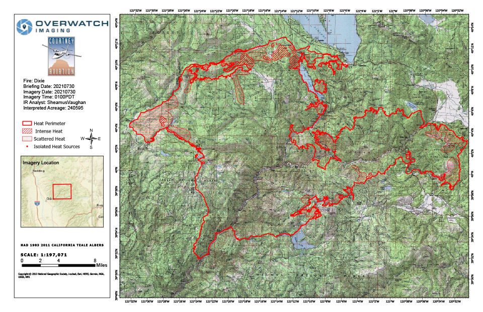
Dixie Fire Infrared Map for Friday, July 30, 2021
Note: 960 Pixels Wide
Flight Notes: No Notes for Friday
Update: Dixie Fire Narrative 7/30/21 (pdf 169 kb)
Update: Dixie Fire West Zone Operations Briefing Video For Friday, July 30, 2021
Update: Dixie Fire East Zone Operations Morning Briefing Video for Friday, July 30, 2021
Update: Smoke/Air Quality Outlook for the Dixie Fire in the Eastern Sierra for Friday, July 30
July 30, 2021 - Dixie Fire in Butte County and Plumas County is 240,595 acres and 24% contained for Friday morning.
Update 9:05 A.M. CAL FIRE
'Click' here to view full PDF
Basic Information
| Current as of | 7/30/2021, 6:43:35 AM |
| Incident Type | Wildfire |
| Cause | Under Investigation |
| Date of Origin | Tuesday July 13th, 2021 approx. 05:15 PM |
| Location | Feather River Canyon near Cresta Powerhouse |
| Incident Commander | CALFIRE Incident Management Team 1/California Interagency Incident Management Team 2 |
| Incident Description | Wildfire |
| Coordinates | 39.819 latitude, -121.419 longitude |
Current Situation
| Total Personnel | 6,079 |
| Size | 240,595 Acres |
| Percent of Perimeter Contained | 24% |
| Estimated Containment Date | Friday August 13th, 2021 approx. 12:00 AM |
| Fuels Involved |
Timber (Litter and Understory) Timber (Grass and Understory) Fuel moistures are historically low, ERCs and BI are in the 97-99% |
| Significant Events |
Active Uphill Runs Backing Flanking Isolated thunderstorms caused the fire activity to increase with down drafts and erratic winds. |
Outlook
| Planned Actions |
Construct direct and indirect line to secure fire perimeter. Construct contingency lines in both zones. Provide structure defense in communities at risk: Paxton, Greenville, Jonesville, Crescent Mills, Taylorsville, Canyondam, Butte Meadows, Bucks Lake, Meadows Valley, and Greater Alamnor area. East Zone: Multiple firing operations will continue. Continue tactical patrol in the communities impacted by fire. |
| Projected Incident Activity |
Fire behavior expected to increase due to drying conditions. Fire continues to move towards controls lines burning unburned interior islands and ridges. Most expected growth will be to the west towards Butte Meadows. On the East Zone expected areas to grow are Division Q(towards the Emigrant Road) and Division X within the Bucks Wilderness area. |
| Remarks |
California Interagency Incident management team 2 (CIIMT 2) has command of the East Zone. State DPA: 6551 Federal DPA: 213461 |
Current Weather
| Weather Concerns |
EAST ZONE: Observed: Patchy dense smoke continued early this afternoon across the Dixie East Zone fire. Afternoon humidity values were beginning to drop into the lower 30 percent range with temperatures climbing into the upper 80s and low 90s. Terrain driven winds were beginning to intensify due to less shading and increased sunshine. Forecast: Hot dry and breezy conditions will continue this afternoon with humidity values falling down into the mid-teens to near 20 percent. Patches of smoke and haze will likely persist in some of the drainage basins and valleys. Highs will remain largely in the mid to upper 90s. There is a less than 20 percent chance for isolated showers across Branches XX and XXIII. The lightning risk is low and the main concern will be gusty outflow winds. For tonight dense smoke and haze will re-settle back into drainage basins resulting in poor visibilities. Overnight low temperatures are not expected to be quite as low in the valleys and drainages, but it'll likely remain chilly with temperatures in the 50s in spots. Overnight humidity values will range as great as 50 percent...even at higher elevations in spots to above 70 percent in the drainage bottoms. WEST ZONE: Strong upper level ridging will bring warm and dry conditions to the area through Fri with well above normal temperatures and worsening overnight RH recoveries along slopes and ridges. Isolated thunderstorms on Thu should stay well east of the fire area over the Sierra mountains though do have a chance of impacting the fire area on Fri. Increasing clouds with very slight chance of an isolated thunderstorms or light showers will lift north across the area Fri night and Sat with drier and winder conditions developing for Mon and Tue. Observed Weather Conditions7/28 Wed afternoon Wind: SW to NW winds 5-10 mph with gusts 15 to 20 mph Max Temp: Low to mid 90s 2000 3000 ft valleys and upper 70s to low 80s 6000-7000 ft ridges Min RH: 18 to 23% as of 1500 but still lowering Expected Weather Conditions 7/28-29 Wed Night Wind: NE locally 15-20 mph with gusts to 30 mph Feather River Canyon and adjacent valleys Min Temp: Upper 60s ridges and upper 50s to mid-60s valleys Max RH: 20-25% ridges and 45-50% valleys Forecasted Weather for Next Operational Period 7/29 Thu Day Shift Wind: SW 8-12 mph gusts 20 mph along ridges Max Temp: Upper 90s 2000-3000 ft valleys to lower 80s 6000-7000 ft ridges Min RH: Low to mid teens Forecasted Weather for Next Operational Period 7/29-30 Thu Night Shift Wind: NE locally 15-20 mph with gusts to 30 mph Feather River Canyon and adjacent valleys Min Temp: Lower 70s ridges and 60s valleys Max RH: Around 20% ridges and 40-45% valleys |
Click here for: Dixie Fire in Butte and Plumas Counties Thursday, July 29, 2021 Updates
