


Click here for Friday Information
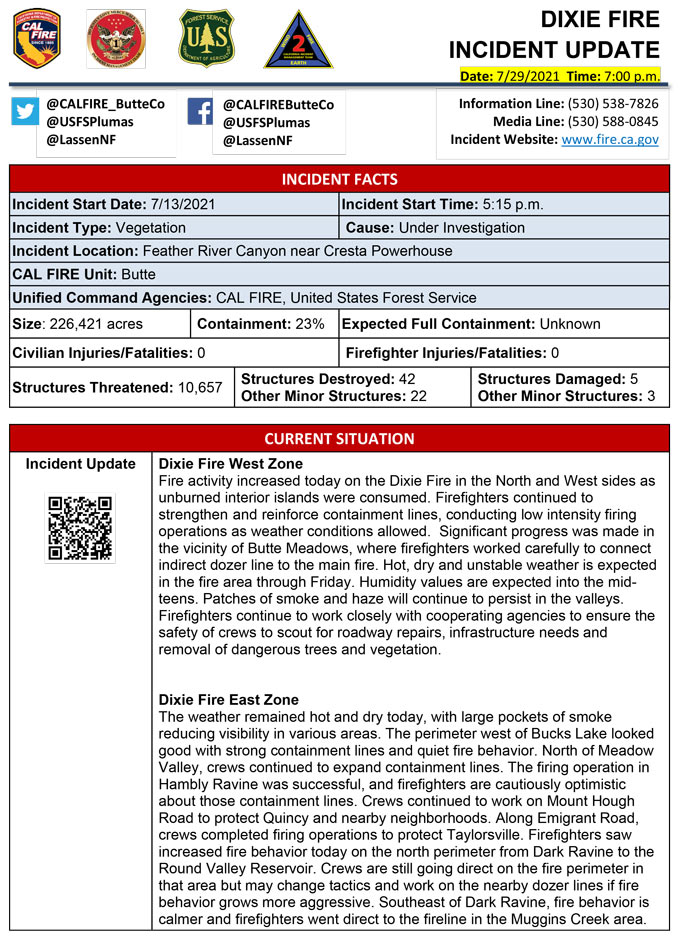
Evening Update Per CAL FIRE: Dixie Fire in Butte County and Plumas County is 226,421 acres and 23% contained for Thursday evening.
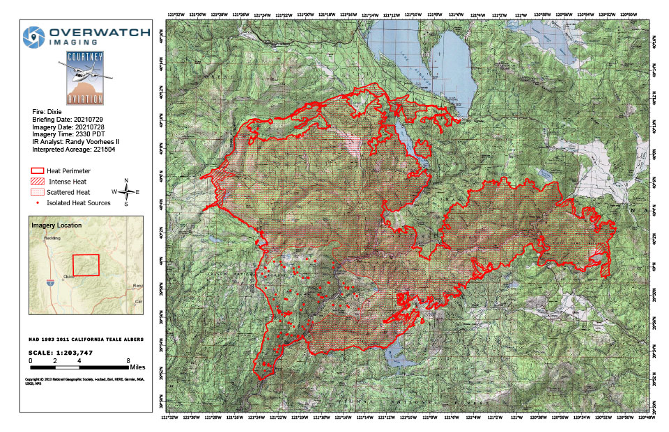
Dixie Fire Infrared Map for Thursday, July 29, 2021
Note: 960 Pixels Wide
Flight Notes:
No heat observed on back side of burnout operations. Scattered heat remains through out most of the fire.
Update: Additional Evacuation Warnings Lifted for the Dixie Fire, Plumas County Sheriff’s Office Reports
Update: Dixie Fire Weather and Behavior Information for Thursday, July 29, 2021
Update: Dixie Fire Evacuation Warning Lifted, Lassen County Sheriff’s Office Reports
Update: Dixie Fire Update for July 29, 2021 (pdf)
Update: Dixie Fire East Zone Operations Morning Briefing Video for Thursday, July 29, 2021
Update: Smoke/Air Quality Outlook for the Dixie Fire in the Eastern Sierra for Thursday, July 29
Update: Dixie Fire in Butte and Plumas Counties Briefing Map for Thursday, July 29, 2021 - Shows Divisions, Uncontrolled Fire Edge, Completed Dozer Lines
July 29, 2021 - Dixie Fire in Butte County and Plumas County is 221,504 acres and 23% contained for Thursday morning.
Update 7:27 A.M. CAL FIRE
'Click' here to view full PDF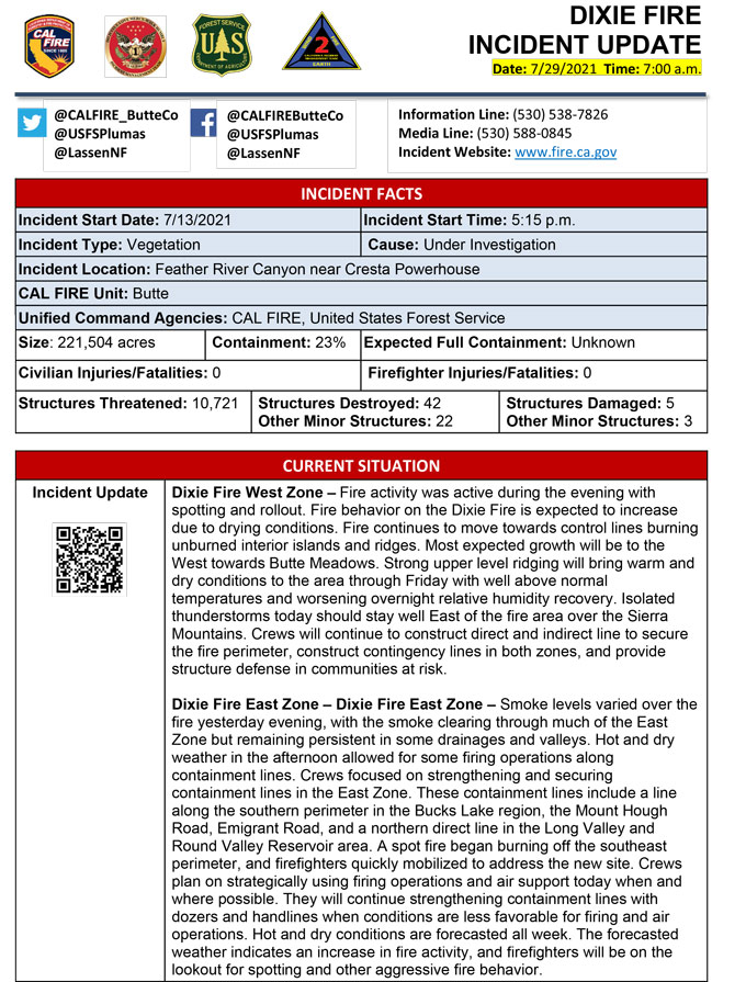
Basic Information
| Current as of | 7/29/2021, 6:43:23 AM |
| Incident Type | Wildfire |
| Cause | Under Investigation |
| Date of Origin | Tuesday July 13th, 2021 approx. 05:15 PM |
| Location | Feather River Canyon near Cresta Powerhouse |
| Incident Commander | CALFIRE Incident Management Team 1/California Interagency Incident Management Team 2 |
| Incident Description | Wildfire |
| Coordinates | 39.819 latitude, -121.419 longitude |
Current Situation
| Total Personnel | 5,931 |
| Size | 221,504 Acres |
| Percent of Perimeter Contained | 23% |
| Estimated Containment Date | Friday August 13th, 2021 approx. 12:00 AM |
| Fuels Involved |
Timber (Grass and Understory) Chaparral (6 feet) |
| Significant Events |
Active Short-range Spotting Backing Flanking Fire activity was active during evening but spotting and rollout continued to be an issue for crews. |
Outlook
| Planned Actions |
Construct direct and indirect line to secure fire perimeter. Construct contingency lines in both zones. Provide structure defense in communities at risk: Paxton, Greenville, Jonesville, Crescent Mills, Taylorsville, Canyondam, Butte Meadows, Bucks Lake, Meadows Valley, and Greater Alamnor area. East Zone: Conduct firing operations as conditions allows. Continue tactical patrol in the communities impacted by fire. |
| Projected Incident Activity |
Fire behavior expected to increase due to drying conditions. Fire continues to move towards controls lines burning unburned interior islands and ridges. Most expected growth will be to the west towards Butte Meadows. On the East Zone other expected areas to grow are Division Q and X towards the Emigrant Road. |
| Remarks |
California Interagency Incident management team 2 (CIIMT 2) has command of the East Zone. State DPA: 6551 Federal DPA: 213461 |
Current Weather
| Weather Concerns |
EAST ZONE: Observed: Dense smoke and patchy fog was noted this morning and into the early afternoon across much of the area. The smoke in fact was so dense it flowed down the Feather River Valley and southward through the Sacramento Valley. This impacted aviation at the Sacramento International Airport. Where clearing has occurred temperatures have increased into the 80s and 90s with relative humidity falling rapidly into the upper teens. Winds were generally westerly though some slight deviations around complex terrain were noted. Speeds ranged between 4 and 12 mph with some gusts to near 15 mph on the ridgelines. Forecast: Hot dry and breezy conditions will continue this afternoon with humidity values falling down into the mid-teens. Areas of smoke and haze will likely persist in some of the drainage basins and valleys. Highs will remain largely in the mid to upper 90s. For tonight dense smoke haze and patchy fog are forecast. Some of the dense smoke may extend up to the mid-slope with just a few of the ridgelines remaining smoke free. It should not be quite as cool tonight compared to the previous night but overnight lows in the valleys may fall down to near 50 degrees. At mid-slope and along ridges temperatures will range between 58 and 65 degrees. Overnight humidity recovery will become elevated and range from near 65 percent at lower elevations to near 35 percent at higher elevations. Some of the higher elevation drainages will see max RH values closer to 50 percent. WEST ZONE: Strong upper level ridging will bring warm and dry conditions to the area through Fri with well above normal temperatures and worsening overnight RH recoveries along slopes and ridges. Isolated thunderstorms on Thu should stay well east of the fire area over the Sierra mountains though do have a chance of impacting the fire area on Fri. Increasing clouds with very slight chance of an isolated thunderstorms or light showers will lift north across the area Fri night and Sat with drier and winder conditions developing for Mon and Tue. Observed Weather Conditions 7/28 Wed afternoon Wind: SW to NW winds 5-10 mph with gusts 15 to20 mph Max Temp: Low to mid 90s 2000-3000 ft valleys and upper 70s to low 80s 6000-7000 ft ridges Min RH: 18 to 23% as of 1500 but still lowering Expected Weather Conditions 7/28-29 WedNight Wind: NE locally 15-20 mph with gusts to 30 mph Feather River Canyon and adjacent valleys Min Temp: Upper 60s ridges and upper 50s to mid-60s valleys Max RH:20-25% ridges and 45-50% valleys Forecasted Weather for Next Operational Period 7/29 Thu Day Shift Wind: SW 8-12 mph gusts 20 mph along ridges Max Temp: Upper 90s 2000-3000 ft valleys to lower 80s 6000 7000 ft ridges Min RH: Low to mid teens Forecasted Weather for Next Operational Period 7/29-30 Thu Night Shift Wind: NE locally 15-20 mph with gusts to 30 mph Feather River Canyon and adjacent valleys Min Temp:Lower 70s ridges and 60s valleys Max RH: Around 20% ridges and 40-45% valleys |
Click here for: Dixie Fire in Butte and Plumas Counties Wednesday, July 28, 2021 Updates
