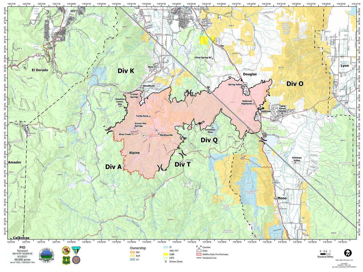
Map for Tuesday, August 3, 2021
Note: 1,200 Pixels Wide
NOTE: Maps represent approximate information.
Update: Bear Cub Burned in the Tamarack Fire Escapes Wildlife Enclosure
Evening Update: The Tamarack Fire as of Tuesday evening is still at 68,696 Acres with 82% Containment.
Basic Information
| Current as of | 8/3/2021, 6:12:31 PM |
| Incident Type | Wildfire |
| Cause | Lightning |
| Date of Origin | Sunday July 04th, 2021 approx. 04:00 PM |
| Location | 16 Miles south of Gardnerville, NV |
| Incident Commander | Scott Stephenson, IC Tom Raw, Deputy IC |
| Incident Description | This Incident Continues To Be Managed With A Full Suppression Strategy, However Steep Inaccessible Terrain In Division Alpha Necessitates A Suppression Strategy Of Confinement. |
| Coordinates | 38.628 latitude, -119.857 longitude |
Current Situation
| Total Personnel | 361 |
| Size | 68,696 Acres |
| Percent of Perimeter Contained | 82% |
| Estimated Containment Date | Tuesday August 31st, 2021 approx. 12:00 AM |
| Fuels Involved |
Timber (Grass and Understory) Chaparral (6 feet) Timber (Litter and Understory) |
| Significant Events |
Moderate Backing Creeping Smoldering Fire is burning in mixed conifer, Pinyon Juniper and brush fuel types, with creeping and smoldering. |
Outlook
| Planned Actions |
Divs K & O - Keep fire south of China Spring and west of Highway 395. Keep fire south of Highway 88 and east of Blue Lake Road. Continue right sizing organization. Divs A & Q - Keep fire north of Highway 89 (Monitor pass) and Hwy 4. Continue right sizing organization. Structure - Secure structures in all Divisions. Continue right sizing organization. |
| Projected Incident Activity |
12 hours: Creeping fire with smoldering and limited potential spread. 24 hours: Creeping and smoldering fire with limited backing or flanking fire possible. |
| Remarks |
Acreage estimated from FireWatch flight on 7/29/2021 at 1322. Steep rugged terrain in Division Alpha necessitates a suppression strategy of confinement. Perimeter in Division Alpha represents 18% of the total fire perimeter. The remaining perimeter (82%) has been fully contained. |
Current Weather
| Weather Concerns |
Today's weather was sunny. High temp 82. Min RH 17%. Upslope winds 3-7 mph in the morning becoming 7-9 mph in the afternoon, G20 mph. HAINES 4-5, LAL 1, CWR 0%. Tonight-Clear. Min temp 57. Max humidity 32%. Light winds. Wednesday-Sunny. High Temps 77 80. Min RH 13-15%. Light upslope in the morning becoming SW 12-17 mph G25-35. HAINES 5-6, LAL 1 CWR 0%. |
Update: Tamarack Fire Operations Briefing Video for Tuesday, August 3, 2021
Update: Smoke/Air Quality Outlook for the Tamarack Fire in Alpine County for Tuesday, August 3
August 3, 2021 - The Tamarack Fire as of Tuesday morning is now at 68,696 Acres with 82% Containment.
Basic Information
| Current as of | 8/3/2021, 10:57:29 AM |
| Incident Type | Wildfire |
| Cause | Lightning |
| Date of Origin | Sunday July 04th, 2021 approx. 04:00 PM |
| Location | 16 Miles south of Gardnerville, NV |
| Incident Commander | Scott Stephenson, IC Tom Raw, Deputy IC |
| Incident Description | This Incident Continues To Be Managed With A Full Suppression Strategy, However Steep Inaccessible Terrain In Division Alpha Necessitates A Suppression Strategy Of Confinement. |
| Coordinates | 38.628 latitude, -119.857 longitude |
Current Situation
| Total Personnel | 344 |
| Size | 68,696 Acres |
| Percent of Perimeter Contained | 82% |
| Estimated Containment Date | Tuesday August 31st, 2021 approx. 12:00 AM |
| Fuels Involved |
Timber (Grass and Understory) Chaparral (6 feet) Timber (Litter and Understory) |
| Significant Events |
Moderate Backing Creeping Smoldering Fire is burning in mixed conifer, Pinyon Juniper and brush fuel types, with creeping and smoldering. |
Outlook
| Planned Actions |
Branch I - Keep fire south of China Spring and west of Highway 395. Keep fire south of Highway 88 and east of Blue Lake Road. Continue right sizing organization. Branch II - Keep fire north of Highway 89 (Monitor pass) and Hwy 4. Continue right sizing organization. Structure - Secure structures in all Branches. Continue right sizing organization. |
| Projected Incident Activity |
12 hours: Creeping fire with smoldering and limited potential spread. 24 hours: Creeping and smoldering fire with limited backing or flanking fire possible. |
| Remarks |
Acreage estimated from FireWatch flight on 7/29/2021 at 1322. Steep rugged terrain in Division Alpha necessitates a suppression strategy of confinement. Perimeter in Division Alpha represents 18% of the total fire perimeter. The remaining perimeter (82%) has been fully contained. |
Current Weather
| Weather Concerns |
Today's weather was partly cloudy. High Temp 76. Min RH 24%. Upslope winds 3-7 mph in the morning becoming SE 7 mph in the morning, increasing to SW to W 7-12 mph in the afternoon. HAINES 4, LAL 1 CWR 5%. Tonight-Partly cloudy becoming clear. Min Temp 46-49. Max humidity around 60-65%. West to NW winds 7-12 mph G22. Tuesday-Sunny. High Temps 77-79. Min RH 18-23%. Light upslope in the morning becoming SE to SW 8-13 mph G25. HAINES 5, LAL 1 CWR 0%. |
Click here for: Tamarack Fire in Alpine County Updates for Monday, August 2, 2021


