


Update: Dixie Fire East Zone Evening Operations Update Video for Friday, August 6, 2021
Update: Lassen County Sheriff's Office Announce Road Closures for Dixie Fire on August 6, 2021
Evening Update Per CAL FIRE: Dixie Fire in Butte County and Plumas County is at 434,813 Acres, with 21% Containment for Friday evening.
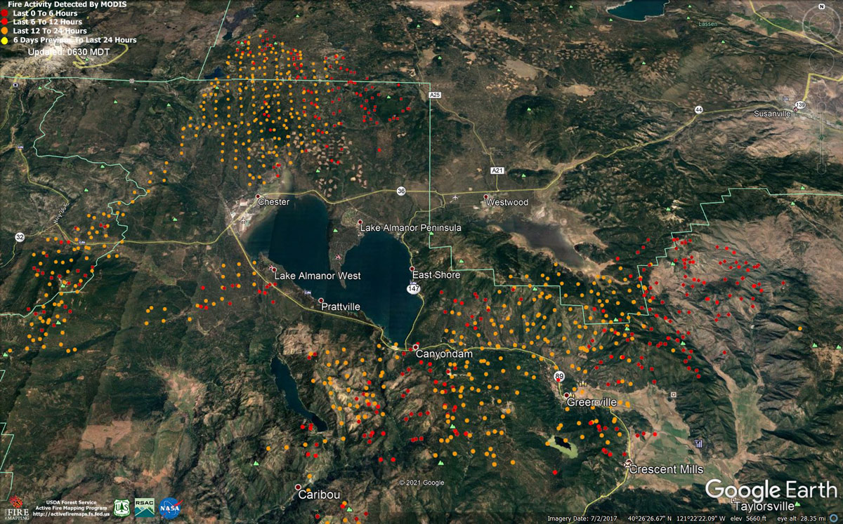
MODIS map of the Dixie Fire in Butte and Plumas Counties on Friday at 5:30 A.M PST
Note: 1,200 Pixels Wide - Note: Older Yellow not shown
MODIS Active Fire Mapping Program Frequently Asked Questions
Update: CAL FIRE Using Unmanned Aerial Systems at the Dixie Fire to Help Look for Spot Fires (Video)
Update Per Lassen National Forest: We're aware of the spot fire visible from Janesville near Lone Rock. There are sparse fuels in the area, so the fire isn't spreading quickly. Dixie East Zone crews are working actively to suppress it.
Update: Current Dixie Fire Road Closures For Friday, Afternoon, August 6, 2021
Update: Plumas County Sheriff's Office Evacuation Order Update on the Dixie Fire
Update: Dixie Fire East Zone Operations Morning Briefing Video for Friday, August 6, 2021
Update: Dixie Fire West Zone Operations Morning Briefing Video For Friday, August 6, 2021
Update: Smoke/Air Quality Outlook for the Dixie Fire in the Eastern Sierra for Friday, August 6
Update: Lassen Volcanic National Park Temporarily Closed Due to Dixie Fire
August 6, 2021 - Dixie Fire in Butte County and Plumas County is 432,813 acres and 35% contained for Friday morning.
Update 7:15 A.M. CAL FIRE
'Click' here to view full PDF
Basic Information
| Current as of | 8/6/2021, 6:38:10 AM |
| Incident Type | Wildfire |
| Cause | Under Investigation |
| Date of Origin | Tuesday July 13th, 2021 approx. 05:15 PM |
| Location | Feather River Canyon near Cresta Powerhouse and Lake Almanor. |
| Incident Commander | CALFIRE Incident Management Team 1/California Interagency Incident Management Team 4 |
| Incident Description | Wildfire |
| Coordinates | 39.819 latitude, -121.419 longitude |
Current Situation
| Total Personnel | 5,222 |
| Size | 432,813 Acres |
| Percent of Perimeter Contained | 35% |
| Estimated Containment Date | Friday August 20th, 2021 approx. 12:00 AM |
| Fuels Involved |
Timber (Litter and Understory) Timber (Grass and Understory) Brush (2 feet) Fuel moistures are historically low, ERCs and BI are in the 97-99% |
| Significant Events |
Active Group Torching Short Crown Runs Short-range Spotting Fire remained very active overnight with warm temperatures, poor RH recoveries, and strong overnight winds fueling fire behavior. |
Outlook
| Planned Actions |
Construct direct and indirect line to secure fire perimeter. Structure Prep along the East Shore. Unable to staff contingency lines due to all resources committed to Fire Front Following, providing structure defense in surrounding impacted communities. Provide structure defense in communities at risk: Chester, Hwy 36 corridor, Hwy 89 Corridor, Paxton, Greenville, Jonesville, Crescent Mills, Taylorsville, Prattville, Canyondam, Butte Meadows, Bucks Lake, Meadows Valley, Rush Creek, Warner Valley, Pecks Valley, Williams Valley, Hunt Canyon, and Greater Almanor area. Continue tactical patrol in the communities impacted by fire. |
| Projected Incident Activity |
12 hours: Fire continues to move towards control lines burning unburned interior islands and ridges. Steep terrain, heavy fuel loading, and wind in alignment with canyons is making control difficult. On West Zone fire is actively burning in division L after spotting across the control line. Its currently impacting structures along the Hwy 36, 89 corridors, West Lake Almanor Area, and impacting surrounding areas. Fire is impacting East shore Almanor, The Peninsula, and Westwood. The mill in Chester is currently threatened. On the East Zone: The start of the Night shift will realize the Red Flag conditions from the Day Operational period for several hours. Expect the fire to remain active through the morning hours. The valleys will see RH recovery up to 65%. There may be potential for crews to make headway on building containment lines. Fire has entered Lassen National Park and is expected to continue burning north through the park. |
| Remarks |
California Interagency Incident Management Team 4 (CIIMT 4) is in command of the East Zone. State DPA: 33487 Federal DPA: 399326 |
Current Weather
| Weather Concerns |
EAST ZONE: Overnight and this morning, weak northeast winds developed over the fire with gusts up to 12 MPH in some areas. Overnight relative humidity recovery was moderate with most areas recovering to the 40-55% range. For today, drift smoke from fire to the north will impact the area. Warmer temperatures are expected today, but depending on the amount of smoke, the warming trend could be muted. Relative humidity will remain dry with minimum values falling to the 10-15% range. Weak northeasterly winds this morning will shift to the southwest by the afternoon with gusts in the 15-25 MPH range. WEST ZONE: Shifting winds associated with a dry cold front challenged containment lines on Thursday. Winds will turn light northeast overnight. This will bring smoke from the Dixie and other fires across the state over the Dixie fire burn area on Friday. Smoke and the conditions behind the front will bring slightly cooler temperatures and higher humidity for Friday. A seasonable weather pattern will set up through the weekend with smoke being the biggest weather factor that will impact fire behavior in the coming days. Observed Weather Conditions: Smoke with plume dominated fire. Otherwise sunny. Wind Speed / Max. Gust West 8-12 mph gusts 22 mph Temp 75 to 85. Direction Southwest RH 9-18% Forecasted Weather for Thursday Operational Period: Smoke Wind Speed / Max. Gust 5-10 mph gusts 15 mph. Temp 75-85 Directions: Northeast morning hours then southwest afternoon. RH 15-25% |
Click here for: Dixie Fire in Butte and Plumas Counties Thursday, August 5, 2021 Updates
