


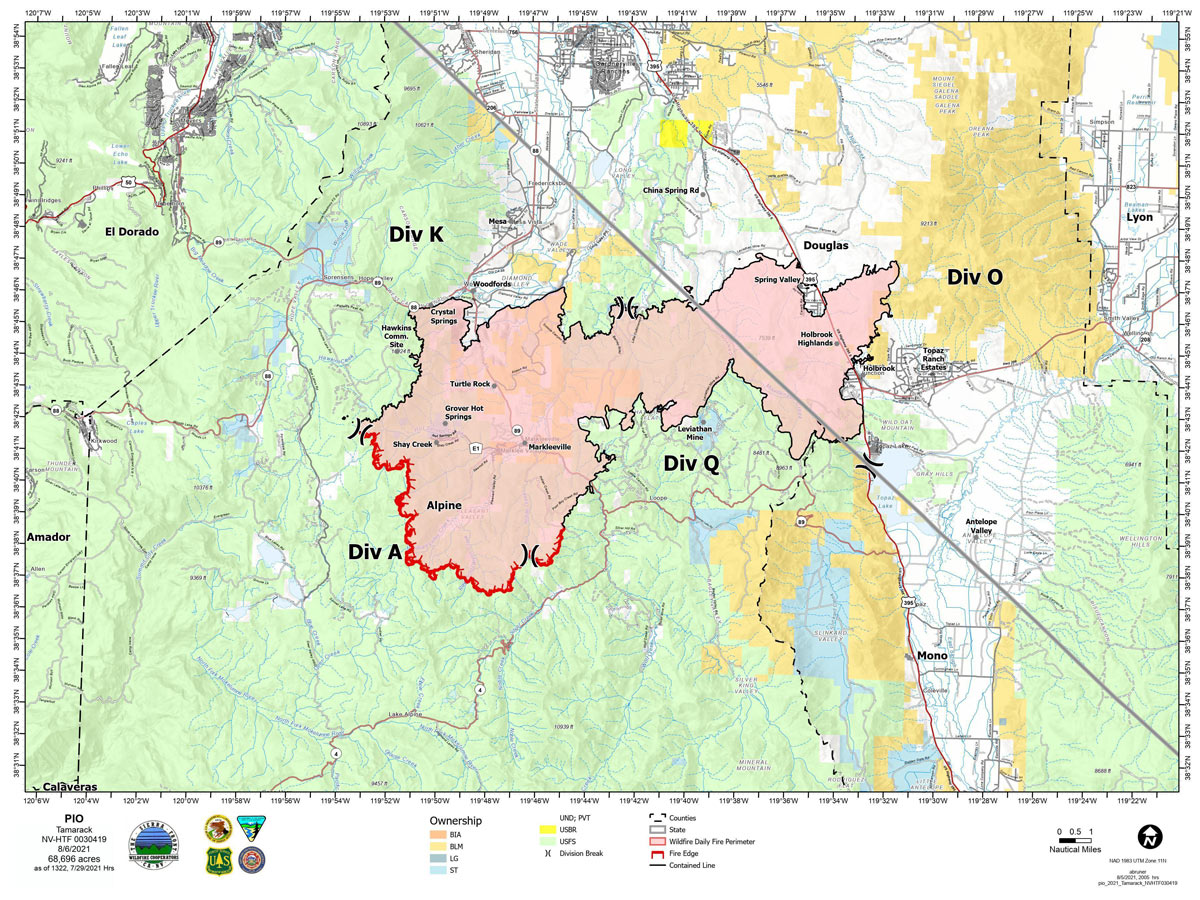
Map for Friday, August 6, 2021
Note: 1,200 Pixels Wide
NOTE: Maps represent approximate information.
Click here for: Tamarack Fire in Alpine County Updates for Saturday, August 7, 2021
Evening Update: The Tamarack Fire as of Friday evening is still at 68,696 Acres with 78% Containment.
Basic Information
| Current as of | 8/6/2021, 6:37:45 PM |
| Incident Type | Wildfire |
| Cause | Lightning |
| Date of Origin | Sunday July 04th, 2021 approx. 04:00 PM |
| Location | 16 Miles south of Gardnerville, NV |
| Incident Commander | Scott Stephenson, IC Tom Raw, Deputy IC |
| Incident Description | This Incident Continues To Be Managed With A Full Suppression Strategy, However Steep Inaccessible Terrain In Division Alpha Necessitates A Suppression Strategy Of Confinement. |
| Coordinates | 38.628 latitude, -119.857 longitude |
Current Situation
| Total Personnel | 434 |
| Size | 68,696 Acres |
| Percent of Perimeter Contained | 78% |
| Estimated Containment Date | Tuesday August 31st, 2021 approx. 12:00 AM |
| Fuels Involved |
Timber (Grass and Understory) Chaparral (6 feet) Timber (Litter and Understory) |
| Significant Events |
Moderate Single Tree Torching Backing Creeping Fire is in mixed conifer, pinyon-juniper, and brush fuel types with creeping, smoldering and single tree torching. |
Outlook
| Planned Actions |
Divs K & O - Keep fire south of China Spring and west of Highway 395. Keep fire south of Highway 88 and east of Blue Lake Road. Continue right sizing organization. Divs A & Q - Keep fire north of Highway 89 (Monitor pass) and Hwy 4. Continue right sizing organization. Structure - Secure structures in all Divisions. Continue right sizing organization. Hazard tree mitigation in Markleeville and Pleasant Valley areas. |
| Projected Incident Activity |
12 hours: Dry conditions will continue across the mid-slopes and ridges overnight. Smoldering and creeping behavior at night. 24 hours: Creeping fire with smoldering and limited to moderate potential for spread. Single tree torching. Drying trend with light winds. |
| Remarks |
Acreage estimated from FireWatch flight on 7/29/2021 at 1322. Steep rugged terrain in Division Alpha necessitates a suppression strategy of confinement. Perimeter in Division Alpha represents 18% of the total fire perimeter. The remaining perimeter (82%) has been contained to 78%. 4% of the fire remains uncontained. |
Current Weather
| Weather Concerns |
Dry conditions with lighter northerly flow prevailed with areas of smoke and haze as northerly winds transported smoke from the Dixie Fire. Heavy inversion in the morning became smoky for remaining of day. Temp's 77-80. Min RH 12-15%. Upslope winds 3-7 mph became northerly 7-10 mph in afternoon. HAINES 4-5, LAL 1, CWR 0%. Tonight-widespread smoke and haze, then clearing. Min Temp 53-54. Max humidity 30-35%. North winds 7-9 mph in evening becoming downslope 2-5 mph. Haines 4. Saturday-Widespread haze and smoke, sunny. Temps 83-86. Min RH 13-16%. Upslope winds 3-7 mph becoming SW 10 mph in the afternoon. HAINES 4-5, LAL 1 CWR 0%. |
Update: Tamarack Fire Operations Briefing Video for Friday Morning, August 6, 2021
August 6, 2021 - The Tamarack Fire as of Friday morning is now at 68,696 Acres with 78% Containment.
Friday, August 6, 2021
Sierra Front Type 3 Incident Management Team 1
Scott Stephenson, Incident Commander
Information Phone: 775-434-8629 (public and media)
Email: 2021.tamarack@firenet.gov
Information Staffing Hours: 8 a.m. to 8 p.m.
Closures, and Fire Restrictions: For closures and fire restrictions on National Forest lands visit https://www.fs.usda.gov/alerts/htnf/alerts-notices.
Click here for: Tamarack Fire in Alpine County Updates for Thursday, August 5, 2021
