


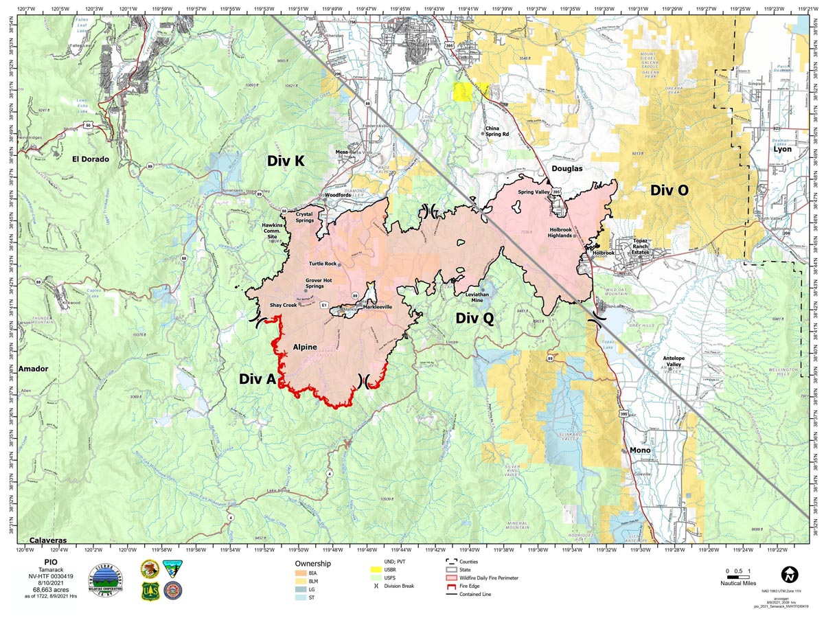
Map for Tuesday, August 10, 2021
Note: 1,200 Pixels Wide
NOTE: Maps represent approximate information.
Evening Update: A dry and unstable airmass persists through Tuesday, along with periods of smoke and haze from fires in Northern California.
Basic Information
| Current as of | 8/10/2021, 5:57:09 PM |
| Incident Type | Wildfire |
| Cause | Lightning |
| Date of Origin | Sunday July 04th, 2021 approx. 04:00 PM |
| Location | 16 Miles south of Gardnerville, NV |
| Incident Commander | Scott Stephenson, IC Tom Raw, Deputy IC |
| Incident Description | This Incident Continues To Be Managed With A Full Suppression Strategy, However Steep Inaccessible Terrain In Division Alpha Necessitates A Suppression Strategy Of Confinement. |
| Coordinates | 38.628 latitude, -119.857 longitude |
Current Situation
| Total Personnel | 403 |
| Size | 68,663 Acres |
| Percent of Perimeter Contained | 80% |
| Estimated Containment Date | Tuesday August 31st, 2021 approx. 12:00 AM |
| Fuels Involved |
Timber (Grass and Understory) Chaparral (6 feet) Timber (Litter and Understory) |
| Significant Events |
Moderate Creeping Backing Smoldering |
Outlook
| Planned Actions |
Divs K & O - Keep fire south of China Spring and west of Highway 395. Keep fire south of Highway 88 and east of Blue Lake Road. Continue right sizing organization. Div K in patrol status. Divs A & Q - Keep fire north of Highway 89 (Monitor pass) and Hwy 4. Continue right sizing organization. Hazard tree mitigation in Markleeville and Pleasant Valley areas. Completing suppression repairs in Div O and Q. |
| Projected Incident Activity |
12 hours: Sunny, haze and smoke. Light and variable winds overnight. Minimal fire behavior. 24 hours: Widespread haze and smoke in the morning. Warming trend with winds shifting to westerly, increased LAL and gusty outflow winds will test containment lines in Division K and possibly increase fire behavior in the Div A/K break and Div A/Q break. |
| Remarks |
Acreage estimated from FireWatch flight on 7/29/2021 at 1322. Steep rugged terrain in Division Alpha necessitates a suppression strategy of confinement. Perimeter in Division Alpha represents 18% of the total fire perimeter. The remaining perimeter (82%) has been contained to 80%. 2% of the fire remains uncontained. |
Current Weather
| Weather Concerns |
A dry and unstable airmass persists through Tuesday, along with periods of smoke and haze from fires in Northern California. Overnight recoveries will remain poor to moderate, especially in thermal belts. It will continue to heat up each day this week with moisture and instability increasing Wednesday through the end of the week. This will bring back the threat of thunderstorms, including lightning and gusty winds, possible flash flood risks on the burn scar. Today's max temp's valleys 90-95, mid-slopes 82-87. RH 13-18%. Light and variable upslope winds 3-7 mph in the morning became N-NE 6-12 mph in afternoon, G 20 mph on ridges. HAINES 5, LAL 1, CWR 0%. Tonight-clear, haze and smoke. Min Temp 56-61 valleys, 61-66 mid-slopes. Max humidity 45-55% valleys, 30-40% mid-slopes. NW winds 6-12 mph in evening with ridges gusting to 20 mph, then light and variable downslope 4-8 mph overnight. Haines 4, LAL 1, CWR 0%. Wednesday-sunny with haze and smoke in the morning. Partly cloudy with isolated showers and thunderstorms after 1200. Chance of thunderstorms 20%. Temps valleys 89-94, mid-slopes 83-88. RH 14-19%. Light and variable upslope winds 3-7 mph in morning becoming 6-12 mph in afternoon. Gusty and erratic outflow winds to 50 mph. LAL 2, CWR 5-10%. Haines 6. Fire behavior will be diminished today into Wednesday morning. |
August 10, 2021 - The Tamarack Fire as of Tuesday morning is now at 68,663 Acres with 80% Containment.
Tamarack Fire Update
Monday, August 10, 2021
Sierra Front Type 3 Incident Management Team 1
Scott Stephenson, Incident Commander
Information Phone: 775-434-8629 (public and media)
Email: 2021.tamarack@firenet.gov
Information Staffing Hours: 8 a.m. to 8 p.m.
Current Situation: Total containment is 80%. The strategy for this fire continues to be full suppression using a combination of containment in Divisions K, O and Q and confinement in Division A. Helicopters will continue to support firefighters with buckets of water on hot spots as weather and smoke conditions permits.
Two suppression repair groups are working on priority areas to minimize impacts of fire suppression activities on natural and cultural resources. Crews are repairing dozer and hand lines to prevent soil erosion and water channeling. They are also removing hazard trees. Hazard trees are fire-damaged and likely to fall on a road or developed site, threatening firefighter and public safety.
Divisions K and O – Division K is now in patrol status. An engine is supporting the repair crew and watching for any hot spots, especially near communities. In Division O, engines and crews are mopping up along the fire line and ensuring containment near homes and structures.
Division Q – Three hand crews are working to strengthen the existing containment line and continue to mop up.
Division A –Two self-sufficient wildland fire modules and an additional hand crew are assigned to Division A. Because of the extremely steep, rugged terrain and the lack of fire movement, firefighters are using a suppression strategy of confinement in this area. Firefighters on the ground, supported by aircraft, are ready to act in the unlikely event the fire crosses established Management Action Points in the surrounding rocky terrain. Helicopter reconnaissance flights, infrared mapping, and time-lapse cameras assist with observation 24 hours a day.
Weather and Fuel Conditions: Widespread smoke and haze continue today, with light and variable winds. The predicted high is 90 degrees, with relative humidity as low as 14%. Fuels remain very dry.
Closures, and Fire Restrictions: For closures and fire restrictions on National Forest lands, visit: https://www.fs.usda.gov/alerts/htnf/alerts-notices.
Tamarack Fire Statistics:
Size: 68,663 acres
Containment: 80%
Total Personnel: 403
Location: Markleeville, CA
Reported: July 4, 2021
Cause: Lightning
For More Information:
Public and media information phone: 775-434-8629
Public and media email: 2021.tamarack@firenet.gov
InciWeb: https://inciweb.nwcg.gov/incident/7674/
Facebook: www.facebook.com/tamarackfireinfo
Twitter: https://twitter.com/tamarack_fire
YouTube: https://bit.ly/TamarackVideo
Air Now: https://fire.airnow.gov/#
Click here for: Tamarack Fire in Alpine County Updates for Monday, August 9, 2021
