


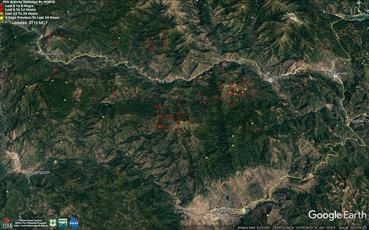
MODIS map of the Monument Fire on Friday at 6:15 A.M PST
Note: 1,200 Pixels Wide - Note: Older Yellow not shown
MODIS Active Fire Mapping Program Frequently Asked Questions
Evening Update Per U.S. Forest Service: California Monument Fire is at 74,759 Acres, with 5% Containment for Friday evening.
Basic Information
| Current as of | 8/13/2021, 9:28:16 PM |
| Incident Type | Wildfire |
| Cause | Lightning |
| Date of Origin | Friday July 30th, 2021 approx. 06:00 PM |
| Location | Del Loma, CA near Monument Peak |
| Incident Commander | Mueller, CAIIMT5 |
| Incident Description | Wildfire |
| Coordinates | 40.752 latitude, -123.337 longitude |
Current Situation
| Total Personnel | 774 |
| Size | 74,759 Acres |
| Percent of Perimeter Contained | 5% |
| Estimated Containment Date | Wednesday September 01st, 2021 approx. 08:00 AM |
| Fuels Involved |
Timber, Brush, Chaparral, Grass, Understory Litter |
| Significant Events |
Upper level monsoonal instability enhanced a warm and dry air mass at the surface to support steady fire spread in all fuel types. Fire growth was primarily a function of rapid uphill runs and roll-out due to steep, complex terrain. Better ventilation provided new growth opportunities along the south side of Trinity River. Western expansion continued with transport winds from the east during the first portion of the day transitioning to the west during the afternoon. Predominate fuel type is converted brush. Heavy dead and down components are dominant in many areas. All live fuels are cured to levels normally seen in late September. |
Outlook
| Planned Actions |
Provide structure preparation, defense and point protection on identified values at risk within the Trinity River drainage, Soldier Creek ,Big Creek, and Canyon Creek. Continue to prepare structures in the Burnt Ranch and Junction City areas. Finish preparation and continue firing the FA 60 road on the western edge of the fire. Begin firing operations on the Soldier Creek road to keep fire to the north. Hold and patrol overnight firing operations. Construct direct and indirect containment line as appropriate and where safe to do so. Prepare for additional planned firing operations. Scout control lines from previous fires for potential use. Patrol and mop up all values at risk in the previously burned areas. |
| Projected Incident Activity |
Fair to good relative humidity recovery will gradually reduce the contribution of fine fuels to fire spread during overnight hours. Daily diurnal wind flow will steer established, deep seated fire both east and west along the 299 corridor towards Junction City and Burnt Ranch. |
| Remarks |
The fire is burning in the footprint of the 2008 Cedar Fire. The terrain is extremely steep and access is difficult. Evacuation orders have been issued for residents of Del Loma and Big Bar on both sides of the Trinity River. |
Current Weather
| Weather Concerns |
Forecast: Elevated moisture continued to move over the region with mostly cloudy skies overnight and a few convective cumulus clouds. Increased stability on Saturday with lingering moisture and partly cloudy skies during the day. Humidities will be a little higher Saturday with moderate to good overnight recoveries. General winds will be up slope and up the Trinity River canyon with gusts to 20 mph in the late afternoon. Light east ridge winds in the morning will become north west in the early afternoon with gusts to 25 mph lasting into the late evening. |
Update: California Monument Fire Operational Update Video for Friday Morning, August 13, 2021
August 13, 2021 - Monument Fire Update for Friday Morning, 74,759 acres with 5% containment.Basic Information
| Current as of | 8/13/2021, 6:34:59 AM |
| Incident Type | Wildfire |
| Cause | Lightning |
| Date of Origin | Friday July 30th, 2021 approx. 06:00 PM |
| Location | Del Loma, CA near Monument Peak |
| Incident Commander | Mueller, CAIIMT5 |
| Incident Description | Wildfire |
| Coordinates | 40.752 latitude, -123.337 longitude |
Current Situation
| Total Personnel | 735 |
| Size | 74,759 Acres |
| Percent of Perimeter Contained | 5% |
| Estimated Containment Date | Wednesday September 01st, 2021 approx. 08:00 AM |
| Fuels Involved |
Timber, Brush, Chaparral, Grass, Understory Litter |
| Significant Events |
Upper level monsoonal instability enhanced a hot and dry air mass at the surface to support steady fire spread in all fuel types. Fire growth was primarily a function of rapid uphill runs and roll-out due to steep, complex terrain. Better ventilation provided new growth opportunities along the south side of Trinity River. Western expansion continued with transport winds from the east during the first portion of the day transitioning to the west during the afternoon. Predominate fuel type is converted brush. Heavy dead and down components are dominant in many areas. All live fuels are cured to levels normally seen in late September. |
Outlook
| Planned Actions |
Provide structure preparation, defense and point protection on identified values at risk within the Trinity River drainage. Prepare structures to receive fire. Scout control lines from previous fires for potential use. Construct direct and indirect containment line as appropriate and where safe to do so. Prepare for planned firing operations. |
| Projected Incident Activity |
Fair relative humidity recovery will gradually reduce the fire spread during overnight hours. Daily diurnal wind flow will steer established, deep seated fire both east and west along the 299 corridor towards Junction City and Burnt Ranch. |
| Remarks |
The fire is burning in the footprint of the 2008 Cedar Fire. The terrain is extremely steep and access is difficult. Evacuation orders have been issued for residents of Del Loma and Big Bar on both sides of the Trinity River. |
Current Weather
| Weather Concerns |
Forecast: Northwest winds will continue overnight with gusty up-canyon winds becoming light down-slope overnight. Humidity recoveries will be poor to moderate. Isolated thunderstorms are possible again on Friday with dry lighting and gusty outflow winds possible.Very hot and dry conditions were experienced over the fire again today with temperatures around 100° and humidities in the teens. Observed: Thunderstorms developed in NE California with some shower activity passing within about 50 miles of the fire area. Southeast upper-level winds in the morning shifted to the northwest during the late afternoon with gusts up to 15 mph in the late afternoon. |
Click here for: California Monument Fire Thursday, August 12, 2021 Updates
