


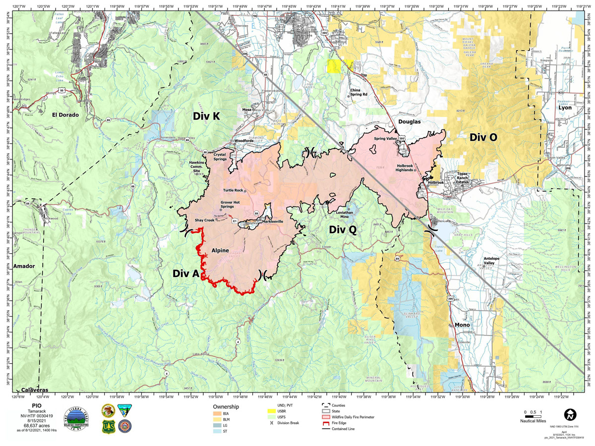
Map for Sunday, August 15, 2021
Note: 1,200 Pixels Wide
NOTE: Maps represent approximate information.
Click here for: Tamarack Fire in Alpine County Updates for Monday, August 16, 2021
Evening Update: Tamarack Fire as of Sunday evening is still at 68,637 Acres with 82% Containment. Minimal fire behavior. Gusty winds could increase fire behavior into Monday morning.
Basic Information
| Current as of | 8/15/2021, 7:10:37 PM |
| Incident Type | Wildfire |
| Cause | Lightning |
| Date of Origin | Sunday July 04th, 2021 approx. 04:00 PM |
| Location | 16 Miles south of Gardnerville, NV |
| Incident Commander | Scott Stephenson, IC Tom Raw, Deputy IC |
| Incident Description | This Incident Continues To Be Managed With A Full Suppression Strategy, However Steep Inaccessible Terrain In Division Alpha Necessitates A Suppression Strategy Of Confinement. |
| Coordinates | 38.628 latitude, -119.857 longitude |
Current Situation
| Total Personnel | 361 |
| Size | 68,637 Acres |
| Percent of Perimeter Contained | 82% |
| Estimated Containment Date | Tuesday August 31st, 2021 approx. 12:00 AM |
| Fuels Involved |
Timber (Grass and Understory) Chaparral (6 feet) Timber (Litter and Understory) |
| Significant Events |
Minimal Creeping Smoldering |
Outlook
| Planned Actions |
Divs K & O - Keep fire south of China Spring and west of Highway 395. Keep fire south of Highway 88 and east of Blue Lake Road. Continue right sizing organization. Div K, O and Q in patrol status. Divs A- Keep fire north of Highway 89 (Monitor pass) and Hwy 4. Continue right sizing organization. Hazard tree mitigation in Markleeville and Pleasant Valley areas. |
| Projected Incident Activity |
12 hours: Minimal fire behavior. Gusty winds could increase fire behavior into Monday morning. 24 hours: Gusty winds could affect Div A by increasing fire behavior. Otherwise minimal fire behavior over most of the fire area. |
| Remarks |
Acreage in Box 7 decreased due to more accurate mapping. Steep rugged terrain in Division Alpha necessitates a suppression strategy of confinement. Perimeter in Division Alpha represents 18% of the total fire perimeter. The remaining perimeter (82%) has been contained. Tamarack fire is assisting with resources on two small fires close to the Tamarack Fire. |
Current Weather
| Weather Concerns |
Isolated showers and thunderstorms possible Sunday afternoon. Thunderstorm activity south of the incident could also send outflow winds northward with gusty/erratic winds possible in the afternoon. Drier conditions will return next week along with increasing W-SW winds Monday and Tuesday possibly resulting in periods of critical conditions. Observed: Sunny, haze. Afternoon cumulus developing. 15% chance for an isolated shower or thunderstorm after 1300. Temps 90-93. Minimum RH 15-19%. Upslope winds 3-7 mph becoming N-NW 7-10 mph early in the afternoon. LAL 2. CWR 0% to 10% in the afternoon. Haines 5. Forecasted: Partly cloudy tonight with isolated thunderstorms and showers in the evening. Maximum RH 45-50%. West winds 7-9 mph in evening becoming light and downslope. Gusty and erratic winds expected near thunderstorms. Monday partly cloudy, breezy. Haze. Upslope winds 3-7 mph becoming west 12-18 mph with gusts to 28 mph. Some exposed slopes could gust up to 35 mph. |
Click here for: Tamarack Fire in Alpine County Updates for Saturday, August 14, 2021
August 15, 2021 - Current Situation: Total containment remains at 82%. The strategy for this fire continues to be full suppression using a combination of containment in Divisions K, O and Q and confinement in Division A. Helicopters will continue to support firefighters in Div A with buckets of water on hot spots as needed. The East suppression group completed its operations yesterday. The West suppression group continues to remove hazard trees from the Pleasant Valley Road and Thornburg Canyon. Hazard trees are fire-damaged and likely to fall on a road or developed sites. These trees pose a significant hazard to firefighter and public safety, road systems and infrastructure.
Yesterday, the west repair group will finished removing hazard trees along Hot Springs Road. Residents in the Markleeville area will continue to see increased vehicle and truck traffic through the weekend.
With recent thunderstorms, the Tamarack Fire has been assisting local initial attack with resources when requested and will continue to do so. Divisions K, O, and Q – Divisions K, O, and Q have all been in put patrol status. Three engines and one hand crew will be patrolling the divisions for the unlikely chance there is a hotspot. Division A – One self-sufficient wildland fire module and two additional hand crews are assigned to Division A. Because of the extremely steep, rugged terrain and the lack of fire movement, firefighters are using a suppression strategy of confinement in this area. Firefighters on the ground, supported by aircraft, are ready to act in the unlikely event the fire crosses established Management Action Points in the surrounding rocky terrain. Wildland fire modules will remain on Div A for the foreseeable future or until a season ending moisture event takes place in the area.
Weather and Fuel Conditions: Smoke and haze will continue today, with isolated showers and thunderstorms in the afternoon. The predicted high is 91-94 degrees, with relative humidity as low as 18%. Fuels remain very dry. Closures, and Fire Restrictions: For closures and fire restrictions on National Forest lands, visit: https://www.fs.usda.gov/alerts/htnf/alerts-notices.
Tamarack Fire Statistics: Size: 68,637 acres Containment: 82% Total Personnel: 347 Location: Markleeville, CA Reported: July 4, 2021 Cause: Lightning For More Information: Public and media information phone: 775-434-8629 Public and media email: 2021.tamarack@firenet.gov InciWeb: https://inciweb.nwcg.gov/incident/7674/ Facebook: www.facebook.com/tamarackfireinfo Twitter: https://twitter.com/tamarack_fire YouTube: https://bit.ly/TamarackVideo Air Now: https://fire.airnow.gov/#
