


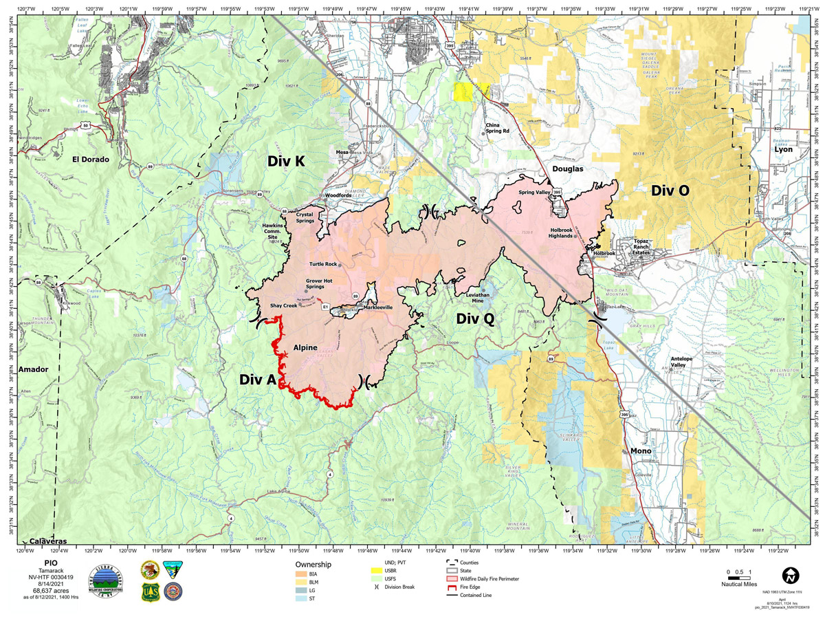
Map for Saturday, August 14, 2021
Note: 1,200 Pixels Wide
NOTE: Maps represent approximate information.
Click here for: Tamarack Fire in Alpine County Updates for Sunday, August 15, 2021
Evening Update: Tamarack Fire as of Saturday evening is still at 68,637 Acres with 82% Containment. Isolated showers and thunderstorms continue through the weekend, with minimal fire behavior.
Basic Information
| Current as of | 8/14/2021, 8:35:04 PM |
| Incident Type | Wildfire |
| Cause | Lightning |
| Date of Origin | Sunday July 04th, 2021 approx. 04:00 PM |
| Location | 16 Miles south of Gardnerville, NV |
| Incident Commander | Scott Stephenson, IC Tom Raw, Deputy IC |
| Incident Description | This Incident Continues To Be Managed With A Full Suppression Strategy, However Steep Inaccessible Terrain In Division Alpha Necessitates A Suppression Strategy Of Confinement. |
| Coordinates | 38.628 latitude, -119.857 longitude |
Current Situation
| Total Personnel | 347 |
| Size | 68,637 Acres |
| Percent of Perimeter Contained | 82% |
| Estimated Containment Date | Tuesday August 31st, 2021 approx. 12:00 AM |
| Fuels Involved |
Timber (Grass and Understory) Chaparral (6 feet) Timber (Litter and Understory) |
| Significant Events |
Minimal Creeping Smoldering |
Outlook
| Planned Actions |
Divs K & O - Keep fire south of China Spring and west of Highway 395. Keep fire south of Highway 88 and east of Blue Lake Road. Continue right sizing organization. Div K, O and Q in patrol status. Divs A- Keep fire north of Highway 89 (Monitor pass) and Hwy 4. Continue right sizing organization. Hazard tree mitigation in Markleeville and Pleasant Valley areas. |
| Projected Incident Activity |
12 hours: Minimal fire behavior. 24 hours: Minimal fire behavior. Widespread smoke and haze in morning will reduce fire behavior. Isolated afternoon showers and thunderstorms in afternoon. Winds shifting from SW to NE with gusts to 20 mph at night. |
| Remarks |
Acreage in Box 7 decreased due to more accurate mapping. Steep rugged terrain in Division Alpha necessitates a suppression strategy of confinement. Perimeter in Division Alpha represents 18% of the total fire perimeter. The remaining perimeter (82%) has been contained. Tamarack fire is assisting with resources on two small fires close to the Tamarack Fire. |
Current Weather
| Weather Concerns |
Isolated showers and thunderstorms will continue through the weekend, though highest chances for heavier rainfall were today. Unstable hot conditions will continue through the weekend. Drier conditions will return next week along with increasing W-SW winds Monday and Tuesday. Observed: Sunny, haze then becoming partly cloudy. Cumulus clouds built over the fire area by 1300 with isolated showers and thunderstorms after 1500. Temps 90-93. Minimum RH 15-19%. Upslope winds 3-7 mph becoming N-NW 7-10 mph early in the afternoon. LAL 2. CWR 0% to 10% in the afternoon. Haines 5. Forecasted: Partly cloudy tonight with isolated thunderstorms and showers. Maximum RH 45-50%. West-NE winds 8-13 mph becoming light. Gusty and erratic winds expected near thunderstorms. Similar weather into Sunday bringing another chance of thunderstorms with gusty and erratic winds that could affect southern part of fire area. LAL 1, minimum RH 19%. |
Update: Tamarack Fire Bear Cub Update - Community No Longer Asked To Be On The Lookout For The Bear Cub
August 14, 2021 - The Tamarack Fire as of Saturday morning is now at 68,637 Acres with 82% Containment.
Basic Information
| Current as of | 8/14/2021, 7:46:22 AM |
| Incident Type | Wildfire |
| Cause | Lightning |
| Date of Origin | Sunday July 04th, 2021 approx. 04:00 PM |
| Location | 16 Miles south of Gardnerville, NV |
| Incident Commander | Scott Stephenson, IC Tom Raw, Deputy IC |
| Incident Description | This Incident Continues To Be Managed With A Full Suppression Strategy, However Steep Inaccessible Terrain In Division Alpha Necessitates A Suppression Strategy Of Confinement. |
| Coordinates | 38.628 latitude, -119.857 longitude |
Current Situation
| Total Personnel | 393 |
| Size | 68,637 Acres |
| Percent of Perimeter Contained | 82% |
| Estimated Containment Date | Tuesday August 31st, 2021 approx. 12:00 AM |
| Fuels Involved |
Timber (Grass and Understory) Chaparral (6 feet) Timber (Litter and Understory) |
| Significant Events |
Minimal Creeping Smoldering |
Outlook
| Planned Actions |
Divs K & O - Keep fire south of China Spring and west of Highway 395. Keep fire south of Highway 88 and east of Blue Lake Road. Continue right sizing organization. Div K & O in patrol status. Divs A & Q - Keep fire north of Highway 89 (Monitor pass) and Hwy 4. Continue right sizing organization. Hazard tree mitigation in Markleeville and Pleasant Valley areas. Completing suppression repairs in Div O and Q. |
| Projected Incident Activity |
12 hours: Minimal fire behavior. Localized moderate behavior on mid-slopes where recoveries are poor and that receive gusty and erratic winds from thunderstorms, especially in southern part of fire area near Div A. 24 hours: Minimal fire behavior. Isolated afternoon showers thunderstorms continuing until 2300. Winds shifting from NE in early afternoon to NW in late afternoon. Smoke and haze during the day and after 2300. |
| Remarks |
Steep rugged terrain in Division Alpha necessitates a suppression strategy of confinement. Perimeter in Division Alpha represents 18% of the total fire perimeter. The remaining perimeter (82%) has been contained. |
Current Weather
| Weather Concerns |
Isolated thunderstorm chances continue into the weekend. Some storms could produce heavy rain and gusty/erratic outflow winds. Unstable and hot conditions will continue to favor plume dominated fire growth this week. Mid-slope recoveries will remain poor to moderate. Observed: Haze and smoke in the morning. Cumulus clouds built over the fire area by 1300 with isolated showers and thunderstorms. Temps 90-93. Minimum RH 14-18%. Upslope winds 3-7 mph becoming N 5-10 mph early in afternoon, then shifting W in late afternoon. Gusty and erratic winds expected near thunderstorms in the afternoon. LAL 1 increasing to 2 after 1300. CWR 0% to 10% in the afternoon. Haines 5. Forecasted: Mostly cloudy tonight with isolated thunderstorms and showers in the evening. West winds 7-9 mph in the evening becoming downslope 2-5 mph. Gusty and erratic winds expected near thunderstorms. Similar weather into Saturday with Haines 4 to 5. |
Click here for: Tamarack Fire in Alpine County Updates for Friday, August 13, 2021
