


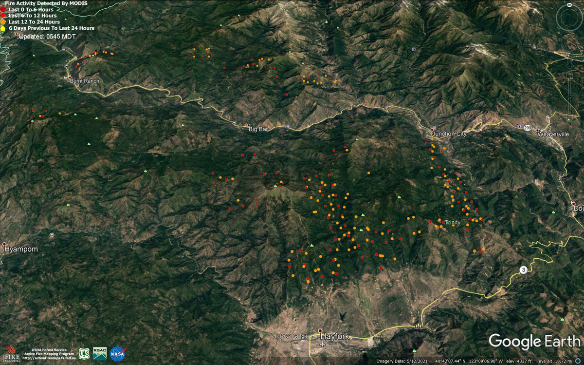
MODIS map of the Monument Fire on Thursday at 4:45 A.M PST
Note: 1,200 Pixels Wide - Note: Older Yellow not shown
MODIS Active Fire Mapping Program Frequently Asked Questions
Evening Update: Monument Fire Update for Thursday evening, the fire has increased to 136,379 Acres with 10% Containment.
Basic Information
| Current as of | 8/19/2021, 8:25:49 PM |
| Incident Type | Wildfire |
| Cause | Lightning |
| Date of Origin | Friday July 30th, 2021 approx. 06:00 PM |
| Location | Del Loma, CA near Monument Peak |
| Incident Commander | Norm McDonald, Alaska IMT and Mike Parkes, CAL FIRE IMT |
| Incident Description | Wildfire |
| Coordinates | 40.752 latitude, -123.337 longitude |
Current Situation
| Total Personnel | 1,583 |
| Size | 136,379 Acres |
| Percent of Perimeter Contained | 10% |
| Estimated Containment Date | Wednesday September 01st, 2021 approx. 08:00 AM |
| Fuels Involved |
The fire remains squarely within the 2008 Buckhorn, Eagle, Miners and Cedar Fire footprints. Type converted brush and a heavy dead and down component dominate most areas. Fuels to the north of Hayfork are characterized as widely spaced mixed conifer and grass. All live fuels are cured to levels normally seen in late September. |
| Significant Events |
Fire is fuels driven resulting out of extended and extreme drought with influence of steep slopes and winds. Dry, breezy conditions from upper level winds from the Northeast brought active fire behavior to the incident. The northeast winds resulted in lower relative humidities, some areas of clear air with increased solar radiation, and new areas of the fire exposed to winds. Consistent fire spread was observed in all fuel types, but accelerated in lighter fuels with a southwest exposures. Limited overnight fire growth was observed as north winds provided mechanism for southward movement towards Hayfork. Elsewhere, fire progression was mostly seen in steeper terrain where backing fire and roll-out allowed the fire to make steady progress. Fire has been chunking away under a cap of smoke and concern exists for increased activity when the cap is removed. |
Outlook
| Planned Actions |
Provide structure defense for the communities of Burnt Ranch, Friedrich Road, Cedar Flat and Underwood Mountain. Patrol and mop-up previous firing operations from Highway 299 to DP 59. Patrol and mop-up previous firing operations from DP 59 south to the intersection of the 60 Road and the 47 Road. Defend structures along Corral Bottom Road/47 Road and prodigy site. Monitor fire on north side of the Trinity River around Ironside Mountain. Patrol and secure current fire line around structures within the communities of Don Juan Point east through Big Flat along the Highway 299 corridor. Continue to keep Ironside Mountain Lookout Road open from Ironside Lookout to Highway 299. Monitor the west side of the New River drainage for any spot fires. Scout for opportunities for indirect line north of the New River from Happy Camp Mountain to the confluence of the Trinity River. Prepare structures along the New River from Five Waters northward. Provide structure defense for the communities from Helena east through Junction City and north along Canyon Creek and the East Fork of the North Fork Trinity River. Finish handline from Canyon Creek west to indirect dozer line along ridges around Helena. Continue to prep structures in Canyon Creek. Evaluate options for managing fire to keep from progressing east of the East Fork of the North Fork and impacting values at risk to the east. Hold, mop-up, and patrol fire lines from the Trinity River south to Hocker Meadow. Prep and secure all structures west of Dutch Creek Road. Verify contingency lines north of Highway 3 from Jordan Road to Maxwell Creek Road. Continue firing operations as approved by Operations Section Chief. Continue with direct, indirect, and contingency line construction and contingency planning. Continue structure protection and working with cooperators to ensure public safety. |
| Projected Incident Activity |
12 hours: Expect active fire growth under the influence of critically dry fuels with influence of northwesterly flow. High resistance to control. Dry conditions will contribute to the potential for spotting and rapid, uphill runs. Predominant fire spread is anticipated in well aligned drainages on the north side of the Trinity River and from the eastern perimeter towards Junction City. Southern growth will threaten Hayfork, as western progression impacts Burnt Ranch and the New River drainage. Within the New River drainage there is potential for slope reversal and progression to the west. 24 hours: Active fire behavior with high resistance to control. Expect burn periods to expand with increased ventilation. Anticipate consistent, but lighter NW winds to develop during the entire burn period to steer established, deep seated fire mostly west along the 299 corridor towards Burnt Ranch and the New River drainage, and south towards Hayfork. |
| Remarks |
Increase in personnel is due to a more complete capture of CAL FIRE resources. |
Current Weather
| Weather Concerns |
Observed Weather: Heavy smoke laid over the Monument fire for much of today's burn period as North winds brought smoke from the River Complex and McCash fires into the region. The smoke stabilized the fire environment, keeping temperatures slightly cooler with higher humidity values where smoke prevailed through the afternoon. Highs mid 70s to mid 80s with afternoon humidity 20-30%. Northerly winds kept smoke plumes pushing southward while winds at the surface remained fairly light. Forecast Weather: Smoke will lay over the fire again tonight with stable and quiet weather as winds ease. Humidity recovery will be moderate from 45-65% most locations with temperatures in the mid 50s to mid 60s overnight. On Friday the forecast calls for some West winds in the afternoon that should start to clear the air across the West side of the fire in Division A and E. As the inversion breaks Friday afternoon fire activity may increase but heavy smoke over the eastern portions of the fire will prevail. Highs in the mid 80s with minimum humidity 15-25%. West winds 5-10 mph gusts 15 mph. |
Monument Fire Update 8/19/2021
Resources: 889 personnel, 12 hand crews, 85 engines, 11 helicopters, 15 dozers, 6 water tenders, 6 masticators, 3 skidgines, 2 excavators.
Virtual Public Meeting: To view a recording of last night’s virtual public meeting held by the Alaska Incident Management Team and CAL FIRE Incident Management Team 5, you can go to the Shasta-Trinity National Forest and @CAL FIRE Shasta Trinity Unit Facebook pages and youtube.com/c/calfireimt5.
Current Situation: The Monument Fire was active on all flanks overnight but show no signs of aggressive movement. The fire is now estimated at 135,714 acres, an increase of almost 7,000 acres. Most of the new growth was on the southeast corner of the fire north and east of Hayfork. Smoke from neighboring fires to the north (River Complex) and northeast (McCash Fire) will lay over the fire area again today, shading it from the sun and lessening fire activity, much like it did on Wednesday. “Smoke is going to drive the fire environment again today with a little cooler temperatures and higher relative humidity,” said Incident Meteorologist Ryan Walbrun. Winds will remain out of the northeast today but won’t be as strong as yesterday. Firefighters will take advantage of the lighter winds and cooler temperatures created by the blanket of smoke over the fire to secure control lines around the perimeter of the fire. Crews will also be monitoring the Highway 299 corridor and pulling hose that was laid around homes that were saved in the communities of Del Loma, Big Bar, Big Flat and Streamwood. Fire managers are working to develop a plan to address a 15-acre spot fire east of the North Fork of the Trinity River along East Fork Road. The spot fire was originally believed to be about 50 acres but smoke prevented fire managers from getting a good size up until yesterday. Crews are hiking into the fire to put a control line around it. If weather allows, retardant may be used to lay a control line on top of a ridge north of Helena and tactical firing operations may be considered to burn off fuel between the ridge and the spot fire to remove energy from the spot fire and prevent uphill runs and reduce spotting potential. On the west side of the fire, crews will continue to monitor a firing operation that was conducted Tuesday along the N60 Road around Chaparral Mountain south of Burnt Ranch. Crews are mopping up the burn to ensure there are no flare-ups that threaten homes. To the north of Burnt Ranch, the fire is holding along Big Creek Road and heavy equipment will begin moving up that road for dozer work along a ridge north of the road to keep the fire from moving north. Crews will also be hunting down and attacking any spot fires found along Big Creek Road. Crews will be moving heavy equipment up Denny Road to open up an old dozer line along Hawkins Bar to keep the fire east of the New River. Crews are also mopping up a spot fire in the Haypress Road area on the south side of the fire east of Pattison Ridge. Heavy equipment will be used to continue construction of a dozer line along Pattison Ridge and to the south to connect with a control line that CAL FIRE is constructing west of Hayfork to box the fire in and keep it east of Hyampom. Crews are also assessing structures in Hyampom in the event they are threatened if the fire moves south. The fire continues to hold along the intertie north of Hyampom. As was the case yesterday, resources in the North Zone will be assisting CAL FIRE Incident Management Team 5 in the South Zone around the communities of Hayfork and Junction City.
Weather: Smoke from the River Complex and McCash Fire will likely continue to linger over the Monument Fire, keeping interior portions of the fire covered in smoke and stable. High temperatures will range from the upper 60s in areas shaded by smoke and to the mid 80s in areas with more sun. Afternoon humidity is expected to be in the 15-25% range.
Evacuation Orders: Remain in effect for Hayfork, Sky Ranch Road, Junction City, Red Hill, Canyon Creek, Coopers Bar, Big Bar, Del Loma, Big Flat, Helena, Cedar Flat, Burnt Ranch and Barker Mountain.
Evacuation Warnings: Remain in effect for Weaverville, Douglas City, areas south from Barker Mountain to Haystack and the north side of Hyampom Road from Hayfork to nine-mile bridge. For detailed evacuation information, visit the Trinity County Office Sheriff Facebook page at Trinity County Sheriff's Office | Facebook
Evacuation Centers: American Red Cross Shelters have been set up at Shasta College, 1555 Old Oregon Trail, Building 1900, Redding CA and Trinity Valley Elementary School, 730 California 96, Willow Creek, CA 95573. The shelter at Trinity Valley Elementary School will move to Willow Creek Bible Church, 39 Barannan Mountain Road, Willow Creek, CA 95573 on Thursday.
Road Closures: State Highway 299 is closed between Burnt Ranch and Junction City. Monitor Caltrans's District 2 website (https://dot.ca.gov/caltrans-near-me/district-2).
Animal Evacuation: (Domestic animals) Trinity County Animal Shelter, 563 Mountain View St, Weaverville, CA
(530- 623-1370) or (Domestic + Large Animals) Hoopa Rodeo Grounds on Pine Creek Rd, Willow Creek, CA.
Property Damage Assessment: Damage assessment teams have confirmed 32 structures have been destroyed. For questions or information regarding the status of your property, call Trinity County Office of Emergency Services (OES) at 530-623-1116.
Forest Closures: Effective August 7, 2021 through October 31, 2021, the Shasta-Trinity Forest has issued Forest Order No. 14-21-21 Monument Fire Closure. Information on the forest order can be found on the Shasta-Trinity National Forest website at Shasta-Trinity NF .
Basic Information
| Current as of | 8/19/2021, 4:48:00 AM |
| Incident Type | Wildfire |
| Cause | Lightning |
| Date of Origin | Friday July 30th, 2021 approx. 06:00 PM |
| Location | Del Loma, CA near Monument Peak |
| Incident Commander | Norm McDonald (AKIMT), Charles Russell, Mike Parkes, Todd Hopkins |
| Incident Description | Wildfire |
| Coordinates | 40.752 latitude, -123.337 longitude |
Current Situation
| Total Personnel | 889 |
| Size | 132,013 Acres |
| Percent of Perimeter Contained | 10% |
| Estimated Containment Date | Wednesday September 01st, 2021 approx. 08:00 AM |
| Fuels Involved |
The fire is burning in the 2008 Cedar Fire, Eagle Fire, Miner's Fire, and Buckhorn Fire burn scars. The predominant fuel type is converted brush. Heavy dead and downed components are dominant in most areas. All live fuels are cured to levels normally seen in late September. Fuels are extremely receptive to spotting. |
| Significant Events |
Despite residual smoke shading and high clouds, a warm, dry, and windy air mass at the surface supported steady fire spread in all fuel types. Fire growth was primarily a function of aggressive surface fire, rapid uphill runs, and roll-out due to steep, complex terrain. Continued ventilation provided new growth opportunities along the Hayfork Divide towards Hayfork. Eastward expansion continued with strong winds from the NW during the day. |
Outlook
| Planned Actions |
Provide structure defense for the communities of Burnt Ranch, Friedrich Road, Cedar Flat and Underwood Mountain. Patrol and mop-up previous firing operations from highway 299 to DP 59. Patrol and mop-up previous firing operations from Highway 299 to DP 59. Patrol and mop-up previous firing operations from DP 59 south to the intersection of the 60 Road and the 47 Road. Defend structures along Corral Bottom Road/47 Road and prodigy site. Monitor fire on north side of the Trinity River around Ironside Mountain. Patrol and secure current fire line around structures within the communities of Don Juan Point east through Big Flat along the Highway 299 corridor. Continue to keep Ironsides Mountain Lookout Road open from Ironsides Lookout to Highway 299. Monitor the west side of the New River drainage for any spot fires. Provide structure defense for the communities from Helena east through Junction City and north along Canyon Creek and the East Fork of the North Fork River. Scout for opportunities for indirect line north of the New River from Happy Camp Mountain to the confluence of the Trinity River. Prepare structures along the New River from Five Waters northward. Provide structure defense for the communities from Helena east through Junction City and north along Canyon Creek and he East Fork of the North Fork of the Trinity River. Finish handline from Canyon Creek west to indirect dozer line along ridges around Helena. Continue to prep structures in Canyon Creek. Hold, mop-up, and patrol fire lines from the Trinity River south to Hocker Meadow. Prep and secure all structures west of Dutch Creek Road. Verify contingency lines north of Highway 3 from Jordan Road to Maxwell Creek Road. Prep and secure all structures west of Dutch Creek Road. Continue firing operations as approved by Operations Section Chief. South Zone Planned Operations: Continue with direct, indirect, and contingency line construction. Continue structure protection and working with cooperators to ensure public safety. |
| Projected Incident Activity |
12 hours: With steady NW winds, fire behavior will remain active due to poor relative humidity recovery. The contribution of fine fuels to fire spread will remain throughout the burn period. Wind flow will steer established, deep-seated fire both west and south along the 299 corridor towards the New River drainage and Hayfork. 24 hours: Expect active burning as typical August heat maintains long burn periods and fully returns the contribution of fine fuels to fire spread. Returning NW wind flow will again steer established, deep seated fire mainly east and south along the 299 corridor towards Junction City and Hayfork. Expect spread towards Ironside Mountain towards the New River drainage into the overnight hours. |
Current Weather
| Weather Concerns |
Red flag warning in effect until 8 pm, Wednesday, for shifting northeast winds strong gusts through sunset. High temperatures on the fire today remained in the upper 60s across southern divisions that were under heavy smoke as the main plume from the River Complex laid over the Monument Fire. Areas on the east side near Junction City that saw more sunshine warmed into the mid 80s with minimum humidity lowering into the mid teens. Forecast: For Wednesday night the main forecast challenge will be continued northeast winds, especially on the ridges that will be adverse to the line in Division A and Z. For Thursday the general wind flow will remain from the Northeast but wind speeds are forecast lighter than previous days. Smoke from the River Complex and McCash Fire will likely continue to linger over the Monument Fire keeping interior portions of the fire covered in smoke and stable. High temperatures upper 60s thick smoke to mid 80s elsewhere. Afternoon humidity 15-25%. |
Click here for: California Monument Fire Wednesday, August 18, 2021 Updates
