


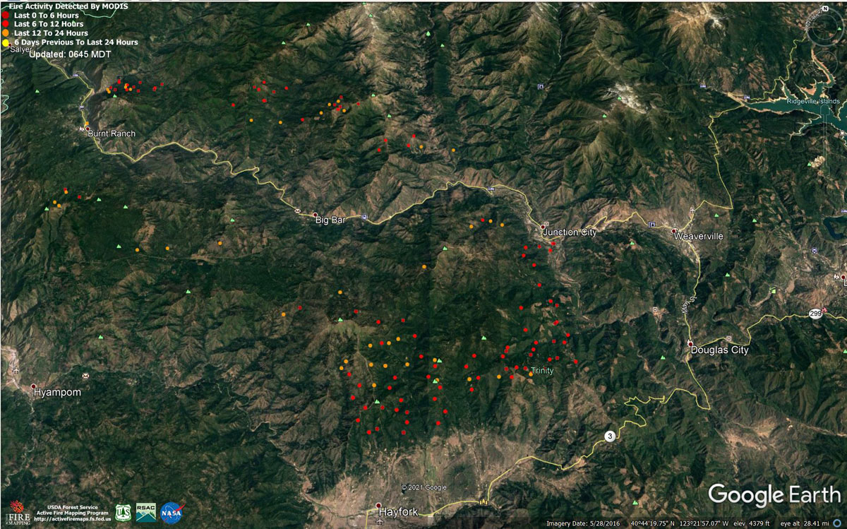
MODIS map of the Monument Fire on Wednesday at 5:45 A.M PST
Note: 1,200 Pixels Wide - Note: Older Yellow not shown
MODIS Active Fire Mapping Program Frequently Asked Questions
Evening Update: Monument Fire Update for Wednesday evening, the fire has increased to 128,613 Acres with 10% Containment.
Basic Information
| Current as of | 8/18/2021, 7:04:51 PM |
| Incident Type | Wildfire |
| Cause | Lightning |
| Date of Origin | Friday July 30th, 2021 approx. 06:00 PM |
| Location | Del Loma, CA near Monument Peak |
| Incident Commander | Norm McDonald (AKIMT), Charles Russell, Mike Parkes, Todd Hopkins |
| Incident Description | Wildfire |
| Coordinates | 40.752 latitude, -123.337 longitude |
Current Situation
| Total Personnel | 889 |
| Size | 128,613 Acres |
| Percent of Perimeter Contained | 10% |
| Estimated Containment Date | Wednesday September 01st, 2021 approx. 08:00 AM |
| Fuels Involved |
The fire is burning in the 2008 Cedar Fire, Eagle Fire, Miner's Fire, and Buckhorn Fire burn scars. The predominant fuel type is converted brush. Heavy dead and downed components are dominant in most areas. All live fuels are cured to levels normally seen in late September. Fuels are extremely receptive to spotting. |
| Significant Events |
Despite residual smoke shading and high clouds, a warm, dry, and windy air mass at the surface supported steady fire spread in all fuel types. Fire growth was primarily a function of aggressive surface fire, rapid uphill runs, and roll-out due to steep, complex terrain. Continued ventilation provided new growth opportunities along the Hayfork Divide towards Hayfork. Eastward expansion continued with strong winds from the NW during the day. |
Outlook
| Planned Actions |
Provide structure defense for the communities of Burnt Ranch, Friedrich Road, Cedar Flat and Underwood Mountain. Patrol and mop-up previous firing operations from highway 299 to DP 59. Patrol and mop-up previous firing operations from Highway 299 to DP 59. Patrol and mop-up previous firing operations from DP 59 south to the intersection of the 60 Road and the 47 Road. Defend structures along Corral Bottom Road/47 Road and prodigy site. Monitor fire on north side of the Trinity River around Ironside Mountain. Patrol and secure current fire line around structures within the communities of Don Juan Point east through Big Flat along the Highway 299 corridor. Continue to keep Ironsides Mountain Lookout Road open from Ironsides Lookout to Highway 299. Monitor the west side of the New River drainage for any spot fires. Provide structure defense for the communities from Helena east through Junction City and north along Canyon Creek and the East Fork of the North Fork River. Scout for opportunities for indirect line north of the New River from Happy Camp Mountain to the confluence of the Trinity River. Prepare structures along the New River from Five Waters northward. Provide structure defense for the communities from Helena east through Junction City and north along Canyon Creek and he East Fork of the North Fork of the Trinity River. Finish handline from Canyon Creek west to indirect dozer line along ridges around Helena. Continue to prep structures in Canyon Creek. Hold, mop-up, and patrol fire lines from the Trinity River south to Hocker Meadow. Prep and secure all structures west of Dutch Creek Road. Verify contingency lines north of Highway 3 from Jordan Road to Maxwell Creek Road. Prep and secure all structures west of Dutch Creek Road. Continue firing operations as approved by Operations Section Chief. South Zone Planned Operations: Continue with direct, indirect, and contingency line construction. Continue structure protection and working with cooperators to ensure public safety. |
| Projected Incident Activity |
12 hours: With steady NW winds, fire behavior will remain active due to poor relative humidity recovery. The contribution of fine fuels to fire spread will remain throughout the burn period. Wind flow will steer established, deep-seated fire both west and south along the 299 corridor towards the New River drainage and Hayfork. 24 hours: Expect active burning as typical August heat maintains long burn periods and fully returns the contribution of fine fuels to fire spread. Returning NW wind flow will again steer established, deep seated fire mainly east and south along the 299 corridor towards Junction City and Hayfork. Expect spread towards Ironside Mountain towards the New River drainage into the overnight hours. |
Current Weather
| Weather Concerns |
Red flag warning in effect until 8 pm, Wednesday, for shifting northeast winds strong gusts through sunset. High temperatures on the fire today remained in the upper 60s across southern divisions that were under heavy smoke as the main plume from the River Complex laid over the Monument Fire. Areas on the east side near Junction City that saw more sunshine warmed into the mid 80s with minimum humidity lowering into the mid teens. Forecast: For Wednesday night the main forecast challenge will be continued northeast winds, especially on the ridges that will be adverse to the line in Division A and Z. For Thursday the general wind flow will remain from the Northeast but wind speeds are forecast lighter than previous days. Smoke from the River Complex and McCash Fire will likely continue to linger over the Monument Fire keeping interior portions of the fire covered in smoke and stable. High temperatures upper 60s thick smoke to mid 80s elsewhere. Afternoon humidity 15-25%. |
Update: CAL FIRE California Statewide Fire Summary for August 18, 2021
Update: California Monument Fire Infrared Map and Information Update for Wednesday, August 18, 2021
Update: Trinity County Sheriff's Office Issues a Monument Fire Evacuation Order for the North Hayfork Valley
Update: Monument Fire Virtual Public Meeting Set for 6:00 P.M. Tonight, August 18, 2021
Update: BLM Temporarily Closes Public Lands in Trinity County Due to Monument Fire in California
August 18, 2021 - Monument Fire Update for Wednesday Morning, 128,613 acres with 10% containment.
Basic Information
| Current as of | 8/18/2021, 6:40:01 AM |
| Incident Type | Wildfire |
| Cause | Lightning |
| Date of Origin | Friday July 30th, 2021 approx. 06:00 PM |
| Location | Del Loma, CA near Monument Peak |
| Incident Commander | Mueller, CAIIMT5 |
| Incident Description | Wildfire |
| Coordinates | 40.752 latitude, -123.337 longitude |
Current Situation
| Total Personnel | 920 |
| Size | 128,613 Acres |
| Percent of Perimeter Contained | 10% |
| Estimated Containment Date | Wednesday September 01st, 2021 approx. 08:00 AM |
| Fuels Involved |
The fire is burning in the 2008 Cedar Fire, Eagle Fire, Miner's Fire, and Buckhorn Fire burn scars. The predominant fuel type is converted brush. Heavy dead and downed components are dominant in most areas. All live fuels are cured to levels normally seen in late September. Fuels are extremely receptive to spotting. |
| Significant Events |
Despite residual smoke shading and high clouds, a warm, dry, and windy air mass at the surface supported steady fire spread in all fuel types. Fire growth was primarily a function of aggressive surface fire, rapid uphill runs, and roll-out due to steep, complex terrain. Continued ventilation provided new growth opportunities along the Hayfork Divide towards Hayfork. Eastward expansion continued with strong winds from the NW during the day. |
Outlook
| Planned Actions |
Provide structure defense for the communities of Burnt Ranch, Friedrich Road, Cedar Flat and Underwood Mountain. Patrol and mop-up previous firing operations from highway 299 to DP 59. Patrol and mop-up previous firing operations from DP 59 south to the intersection of the 60 Rd and the 47 Rd. Defend structures along Corral Bottom Rd./47 Rd. and Prodigy site. Monitor fire on North side of Trinity River around Ironside Mountain. Patrol and secure current fire line around structures within the communities of Don Juan Point east through Big Flat along the Highway 299 corridor. Continue to keep Ironsides Mountain Lookout Road open from lookout to Highway 299. Monitor the west side of the new river drainage for any spot fires. Provide structure defense for the communities from Helena east through Junction City and north along Canyon Creek and East Fork of the North Fork River. Scout for opportunities for indirect line north of the New River from Happy Camp Mtn. to the confluence of the Trinity River. Prepare structures along the New River from Five Waters northward. Provide structure defense for the communities from Helena east through Junction City and north along Canyon Creek and the East Fork of the North Fork of the Trinity River. Finish handline from Canyon Creek west to indirect dozer line along ridges around Helena. Continue to prep structures in Canyon Creek. Hold, mop-up, and patrol fire lines from the Trinity River south to Hocker Mdw. Prep and secure all structures west of Dutch Creek Rd. Verify contingency lines north of Hwy 3 from Jordan Rd. to Maxwell Creek Rd. Continue firing operations as approved by Operations Section Chief. Reopen existing dozer lines and roads from N29 rd west along Pattison Ridge to Pattison Park and then south to the Pattison cutoff. Continue mop up at Hayfork Bally around the Lookout and Trinity County infrastructure. Patrol and mop-up from DP30 south along the N29 rd. Scout locations to construct direct line which have a high probably of stopping fire spread to the south towards Hayfork. |
| Projected Incident Activity |
12 hrs: With steady NW winds, fire behavior will remain active due to poor relative humidity recovery. The contribution of fine fuels to fire spread will remain throughout the burn period. Wind flow will steer established, deep-seated fire both west and south along the 299 corridor towards the New River drainage and Hayfork. |
| Remarks |
The fire is burning in the footprint of the 2008 Cedar Fire, Eagle Fire and Buckhorn Fire burn scars. The terrain is extremely steep and access is difficult. Evacuation orders have been issued for residents of Del Loma and Big Bar on both sides of the Trinity River. |
Current Weather
| Weather Concerns |
Red flag warning for gusty winds and low humidity through early morning. Ridge level winds developed from the NW this morning and picked up in the late afternoon with gusts up to 25-30 MPH in the late afternoon. Upslope winds picked up in the afternoon with gusts up to 25mph in the Trinity River Canyon. Drier air that moved into the region today brought daytime humidities down to 10-20%. Forecast: Winds will stay gusty from the NW through late evening. Upper-level winds will shift to the north overnight with NE winds developing on Wednesday. Much drier air will move into the region with poor overnight recoveries along the ridges with poor to moderate recoveries in the valleys. |
Click here for: California Monument Fire Tuesday, August 17, 2021 Updates
