


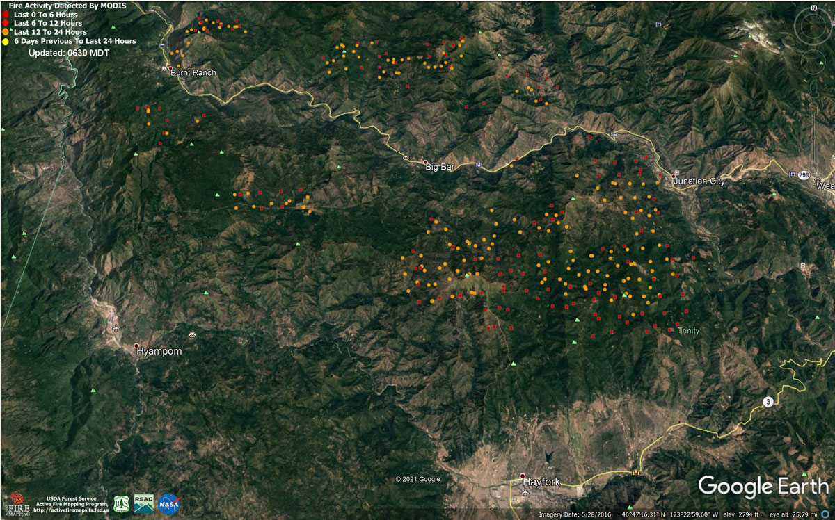
MODIS map of the Monument Fire on Tuesday at 5:30 A.M PST
Note: 1,200 Pixels Wide - Note: Older Yellow not shown
MODIS Active Fire Mapping Program Frequently Asked Questions
Evening Update: Monument Fire Update for Tuesday evening, the fire has increased to 119,364 Acres with 10% Containment.
Basic Information
| Current as of | 8/17/2021, 9:02:54 PM |
| Incident Type | Wildfire |
| Cause | Lightning |
| Date of Origin | Friday July 30th, 2021 approx. 06:00 PM |
| Location | Del Loma, CA near Monument Peak |
| Incident Commander | Mueller, CAIIMT5 |
| Incident Description | Wildfire |
| Coordinates | 40.752 latitude, -123.337 longitude |
Current Situation
| Total Personnel | 920 |
| Size | 119,364 Acres |
| Percent of Perimeter Contained | 10% |
| Estimated Containment Date | Wednesday September 01st, 2021 approx. 08:00 AM |
| Fuels Involved |
The fire is burning in the 2008 Cedar Fire, Eagle Fire, Miner's Fire, and Buckhorn Fire burn scars. The predominant fuel type is converted brush. Heavy dead and downed components are dominant in most areas. All live fuels are cured to levels normally seen in late September. Fuels are extremely receptive to spotting. |
| Significant Events |
Despite residual smoke shading and high clouds, a warm, dry, and windy air mass at the surface supported steady fire spread in all fuel types. Fire growth was primarily a function of aggressive surface fire, rapid uphill runs, and roll-out due to steep, complex terrain. Continued ventilation provided new growth opportunities along the Hayfork Divide towards Hayfork. Eastward expansion continued with strong winds from the NW during the day. |
Outlook
| Planned Actions |
Provide structure defense for the communities of Burnt Ranch, Friedrich Road, Cedar Flat and Underwood Mountain. Patrol and mop-up previous firing operations from highway 299 to DP 59. Patrol and mop-up previous firing operations from DP 59 south to the intersection of the 60 Rd and the 47 Rd. Defend structures along Corral Bottom Rd./47 Rd. and Prodigy site. Monitor fire on North side of Trinity River around Ironside Mountain. Patrol and secure current fire line around structures within the communities of Don Juan Point east through Big Flat along the Highway 299 corridor. Continue to keep Ironsides Mountain Lookout Road open from lookout to Highway 299. Monitor the west side of the new river drainage for any spot fires. Provide structure defense for the communities from Helena east through Junction City and north along Canyon Creek and East Fork of the North Fork River. Scout for opportunities for indirect line north of the New River from Happy Camp Mtn. to the confluence of the Trinity River. Prepare structures along the New River from Five Waters northward. Provide structure defense for the communities from Helena east through Junction City and north along Canyon Creek and the East Fork of the North Fork of the Trinity River. Finish handline from Canyon Creek west to indirect dozer line along ridges around Helena. Continue to prep structures in Canyon Creek. Hold, mop-up, and patrol fire lines from the Trinity River south to Hocker Mdw. Prep and secure all structures west of Dutch Creek Rd. Verify contingency lines north of Hwy 3 from Jordan Rd. to Maxwell Creek Rd. Continue firing operations as approved by Operations Section Chief. Reopen existing dozer lines and roads from N29 rd west along Pattison Ridge to Pattison Park and then south to the Pattison cutoff. Continue mop up at Hayfork Bally around the Lookout and Trinity County infrastructure. Patrol and mop-up from DP30 south along the N29 rd. Scout locations to construct direct line which have a high probably of stopping fire spread to the south towards Hayfork. |
| Projected Incident Activity |
12 hrs: With steady NW winds, fire behavior will remain active due to poor relative humidity recovery. The contribution of fine fuels to fire spread will remain throughout the burn period. Wind flow will steer established, deep-seated fire both west and south along the 299 corridor towards the New River drainage and Hayfork. |
| Remarks |
The fire is burning in the footprint of the 2008 Cedar Fire, Eagle Fire and Buckhorn Fire burn scars. The terrain is extremely steep and access is difficult. Evacuation orders have been issued for residents of Del Loma and Big Bar on both sides of the Trinity River. |
Current Weather
| Weather Concerns |
Red flag warning for gusty winds and low humidity through early morning. Ridge level winds developed from the NW this morning and picked up in the late afternoon with gusts up to 25-30 MPH in the late afternoon. Upslope winds picked up in the afternoon with gusts up to 25mph in the Trinity River Canyon. Drier air that moved into the region today brought daytime humidities down to 10-20%. Forecast: Winds will stay gusty from the NW through late evening. Upper-level winds will shift to the north overnight with NE winds developing on Wednesday. Much drier air will move into the region with poor overnight recoveries along the ridges with poor to moderate recoveries in the valleys. |
Update: Trinity County Sheriff Tim Saxon Answers Monument Fire Community Meeting Questions
Update: California Monument Fire Infrared Map and Public Information Map for Tuesday, August 17, 2021August 17, 2021 - Monument Fire Update for Tuesday Morning, 119,280 acres with 10% containment.
Basic Information
| Current as of | 8/17/2021, 6:30:54 AM |
| Incident Type | Wildfire |
| Cause | Lightning |
| Date of Origin | Friday July 30th, 2021 approx. 06:00 PM |
| Location | Del Loma, CA near Monument Peak |
| Incident Commander | Mueller, CAIIMT5 |
| Incident Description | Wildfire |
| Coordinates | 40.752 latitude, -123.337 longitude |
Current Situation
| Total Personnel | 911 |
| Size | 119,280 Acres |
| Percent of Perimeter Contained | 10% |
| Estimated Containment Date | Wednesday September 01st, 2021 approx. 08:00 AM |
| Fuels Involved |
The predominant fuel type is converted brush. Heavy dead and down components are dominant in many areas. All live fuels are cured to levels normally seen in late September and fuels are extremely receptive to spotting. |
| Significant Events |
Despite smoke shading over the east portions of the fire, a warm, dry and windy air mass at the surface is supporting steady fire spread in all fuel types. Fire growth was primarily a function of aggressive active crown fire, rapid uphill runs and roll-out due to steep, complex terrain. Better ventilation provided new growth opportunities along the Hayfork divide towards Hayfork. Eastward expansion continued with strong winds from the northwest during the day. |
Outlook
| Planned Actions |
Provide structure defense for the communities of Burnt Ranch, Friedrich Road, Cedar Flat and Underwood Mountain. Patrol and mop-up previous firing operations from highway 299 to DP 59. Conduct firing operations from DP 59 south to the intersection of the 60 Rd and the 47 Rd. Continue firing operations from the N23 Road to the 28A spur. Defend structures along Corral Bottom Rd./47 Rd. and Prodigy site. Monitor fire on North side of Trinity River around Ironside Mountain. Patrol and secure current fire line around structures within the communities of Don Juan Point east through Big Flat along the Highway 299 corridor. Continue to keep Ironsides Mountain Lookout Road open from lookout to Highway 299. Monitor the west side of the new river drainage for any spot fires. Provide structure defense for the communities from Helena east through Junction City and north along Canyon Creek and East Fork of the North Fork River. Scout for opportunities for indirect line north of the New River from Happy Camp Mtn. to the confluence of the Trinity River. Start preparing structure along the New River from Five Waters northward. Provide structure defense for the communities from Helena east through Junction City and north along Canyon Creek and the East Fork of the North Fork of the Trinity River. Finish handline from Canyon Creek west to indirect dozer line along ridges around Helena to keep fire from spreading into Canyon Creek and Junction City. Continue to prep structures in Canyon Creek. Hold, mop-up, and patrol fire lines from the Trinity River south to Hocker Mdw. Complete preparation of the indirect lines along Dutch Creek rd to the division W/X break. Prep and secure all structures west of Dutch Creek Rd. Verify contingency lines north of Hwy 3 from Jordan Rd. to Maxwell Creek Rd. Continue firing operations as approved by Operations Section Chief. Reopen existing dozer lines and roads from N29 rd west along Pattison Ridge to Pattison Park and then south to the Pattison cutoff. Continue mop up at Hayfork Bally around the Lookout and Trinity County infrastructure. Patrol and mop-up from DP30 south along the N29 rd. Scout locations to construct direct lines which have a high probably of stopping fire spread to the south towards Hayfork. |
| Projected Incident Activity |
12 hrs: With steady NW winds, fire behavior will remain active despite fair to good relative humidity recovery. Areas sheltered from the NW wind flow will see a reduction in the contribution of fines fuels to fire spread during the late overnight hours. Wind flows will steer established deep-seated fire both east and south along the 299 corridor towards Junction City, Barker Mountain and Hayfork. Flanking spread around Ironside Mountain will slowly work westward towards the New River drainage. |
| Remarks |
The fire is burning in the footprint of the 2008 Cedar Fire, Eagle Fire and Buckhorn Fire burn scars. The terrain is extremely steep and access is difficult. Evacuation orders have been issued for residents of Del Loma and Big Bar on both sides of the Trinity River. |
Current Weather
| Weather Concerns |
Hot and dry conditions continued over the fire again today with temps in the 90's and relative humidities in the teens and low 20's. Ridge level winds started from the NW this morning and picked up throughout the day with gusts up to 25 MPH in the late afternoon. Upslope winds picked up in the afternoon with gusts up to 25 MPH in the Trinity River Canyon. Smoke conditions began clearing on the West side early and then remained clear over most of the fire during the remainder of the day. Forecast: Winds will remain gusty from the NW along the ridges and exposed terrain overnight tonight with stronger NW winds expected on Tuesday. Good to moderate overnight recoveries over the Trinity River Canyon with poor recoveries along the ridges. |
Click here for: California Monument Fire Monday, August 16, 2021 Updates
