


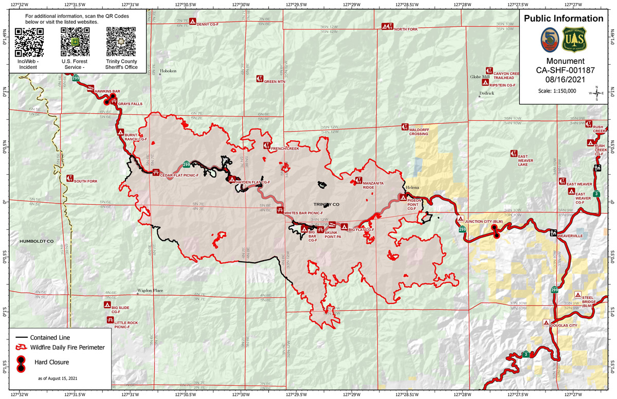
Monument Fire Public Information Map for Monday, August 16, 2021.
Click here for: California Monument Fire Tuesday, August 17, 2021 Updates
Evening Update: Monument Fire Update for Monday evening, the fire has increased to 102,883 Acres with 10% Containment.
Basic Information
| Current as of | 8/16/2021, 6:22:46 PM |
| Incident Type | Wildfire |
| Cause | Lightning |
| Date of Origin | Friday July 30th, 2021 approx. 06:00 PM |
| Location | Del Loma, CA near Monument Peak |
| Incident Commander | Mueller, CAIIMT5 |
| Incident Description | Wildfire |
| Coordinates | 40.752 latitude, -123.337 longitude |
Current Situation
| Total Personnel | 847 |
| Size | 102,883 Acres |
| Percent of Perimeter Contained | 10% |
| Estimated Containment Date | Wednesday September 01st, 2021 approx. 08:00 AM |
| Fuels Involved |
The predominant fuel type is converted brush. Heavy dead and down components are dominant in many areas. All live fuels are cured to levels normally seen in late September and fuels are extremely receptive to spotting. |
| Significant Events |
Despite heavy smoke shading, a warm and dry air mass at the surface is supporting steady fire spread in all fuel types. Fire growth was primarily a function of rapid uphill runs and roll-out due to steep, complex terrain. Better ventilation provided new growth opportunities along the Hayfork divide near Hayfork Bally. Eastward expansion continued with transport winds from the south and west during the first portion of the day; transitioning to the northwest during the afternoon. |
Outlook
| Planned Actions |
Provide structure defense for the communities of Burnt Ranch, Friedrich Road, Cedar Flat and Underwood Mountain. Patrol and mop-up previous firing operations from highway 299 to DP 59. Conduct firing operations from DP 59 south towards DP 52. Continue to prepare Underwood Mountain Road, the 60 road and indirect handline / dozer line from DP 52 south to DP 50. Defend structures along Corral Bottom road / 47 road, at prodigy site. Monitor fire on north side of the Trinity River south of Ironsides Lookout. Patrol and secure current fire line around structures within the communities of Don Juan Point east through Big Flat along the Highway 299 corridor. Continue to keep Ironsides Mountain Lookout Road open from lookout to Highway 299. Monitor the west side of the new river drainage for any spot fires. Provide structure defense for the communities from Helena east through Junction City and north along Canyon Creek and East Fork of the North Fork River. Finish handline from Canyon Creek west to indirect dozer line along ridges around Helena to keep fire from spreading into Canyon Creek and Junction City. Continue to prep structures in Canyon Creek. Scout locations to construct direct line which have a high probability of stopping fire spread to the south and east. Hold, mop-up, and patrol fire lines from the Trinity River south to Hocker Mdw. Complete preparation of contingency lines along Dutch Creek rd to the division W/X break. Prep and secure all structures west of Dutch Creek rd. Continue firing operations along the 3N48 south to the 3N51 rd and north to Rattle Snake Ridge to keep the fire west of Dutch Creek rd. Continue the dozer line from Dutch Creek rd. west to 3N08 Soldier Creek rd and from Dutch Creek rd west to 3N48 rd on the east side of Maple Creek. Prepare the 3N47 rd south to DP72 for firing operations. Prepare indirect line from the 3N47 rd north to the 3N32 rd. Initiate firing operations along the 3N47 rd southwest to the 16 rd. Reopen existing dozer lines and roads from N29 rd west along Pattison Ridge to Pattison Park and then south to the Pattison cutoff. Continue structure prep at Hayfork Bally around the Lookout and Trinity County infrastructure. Patrol and mop-up from DP30 south along the N29 rd. Scout locations to construct direct lines which have a high probably of stopping fire spread to the south towards Hayfork. |
| Projected Incident Activity |
Once NW winds diminish, fair to good relative humidity recovery will gradually reduce the contribution of fine fuels to fire spread during overnight hours. Daily diurnal wind flow will steer established, deep seated fire both east and west along the 299 corridor towards Junction City and Burnt Ranch. |
| Remarks |
The fire is burning in the footprint of the 2008 Cedar Fire, Eagle Fire and Buckhorn Fire burn scars. The terrain is extremely steep and access is difficult. Evacuation orders have been issued for residents of Del Loma and Big Bar on both sides of the Trinity River. |
Current Weather
| Weather Concerns |
Hot and dry conditions were experienced over the fire again today with temperatures in the 80s and 90s and relative humidity percentages in the low 20s. Early onset northwest winds began in the morning and built in strength throughout the afternoon with gusts reaching 25 to 30 mph by late afternoon. Upslope winds picked up in the afternoon with gusts up to 20mph in the Trinity River Canyon. Thick smoke in the morning with some clearing along the higher terrain along Burnt Ranch during the afternoon. Forecast: Winds with remain gusty from the northwest along the ridges and exposed terrain overnight tonight with stronger northwest winds expected on Monday. Good to moderate overnight recoveries in the Trinity River Canyon with poor recoveries along the ridges. |
Update: CAL FIRE Statewide Fire Update Video for Monday, August 16, 2021
Updated (with Map): Trinity County Sheriff's Office Issues Evacuation Warnings and Orders for the Monument Fire
August 16, 2021 - Monument Fire Update for Monday Morning, 97,287 acres with 10% containment.
Basic Information
| Current as of | 8/16/2021, 5:31:40 AM |
| Incident Type | Wildfire |
| Cause | Lightning |
| Date of Origin | Friday July 30th, 2021 approx. 06:00 PM |
| Location | Del Loma, CA near Monument Peak |
| Incident Commander | Mueller, CAIIMT5 |
| Incident Description | Wildfire |
| Coordinates | 40.752 latitude, -123.337 longitude |
Current Situation
| Total Personnel | 847 |
| Size | 97,287 Acres |
| Percent of Perimeter Contained | 10% |
| Estimated Containment Date | Wednesday September 01st, 2021 approx. 08:00 AM |
| Fuels Involved |
The predominant fuel type is converted brush. Heavy dead and down components are dominant in many areas. All live fuels are cured to levels normally seen in late September and fuels are extremely receptive to spotting. |
| Significant Events |
Despite heavy smoke shading, a warm and dry air mass at the surface is supporting steady fire spread in all fuel types. Fire growth was primarily a function of rapid uphill runs and roll-out due to steep, complex terrain. Better ventilation provided new growth opportunities along the Hayfork divide near Hayfork Bally. Eastward expansion continued with transport winds from the south and west during the first portion of the day; transitioning to the northwest during the afternoon. |
Outlook
| Planned Actions |
Provide structure defense for the communities of Burnt Ranch, Friedrich Road, Cedar Flat and Underwood Mountain. Patrol and mop-up previous firing operations from highway 299 to DP 59. Conduct firing operations from DP 59 south towards DP 52. Continue to prepare Underwood Mountain Road, the 60 road and indirect handline / dozer line from DP 52 south to DP 50. Defend structures along Corral Bottom road / 47 road, at prodigy site. Monitor fire on north side of the Trinity River south of Ironsides Lookout. Patrol and secure current fire line around structures within the communities of Don Juan Point east through Big Flat along the Highway 299 corridor. Continue to keep Ironsides Mountain Lookout Road open from lookout to Highway 299. Monitor the west side of the new river drainage for any spot fires. Provide structure defense for the communities from Helena east through Junction City and north along Canyon Creek and East Fork of the North Fork River. Finish handline from Canyon Creek west to indirect dozer line along ridges around Helena to keep fire from spreading into Canyon Creek and Junction City. Continue to prep structures in Canyon Creek. Scout locations to construct direct line which have a high probability of stopping fire spread to the south and east. Hold, mop-up, and patrol fire lines from the Trinity River south to Hocker Mdw. Complete preparation of contingency lines along Dutch Creek rd to the division W/X break. Prep and secure all structures west of Dutch Creek rd. Continue firing operations along the 3N48 south to the 3N51 rd and north to Rattle Snake Ridge to keep the fire west of Dutch Creek rd. Continue the dozer line from Dutch Creek rd. west to 3N08 Soldier Creek rd and from Dutch Creek rd west to 3N48 rd on the east side of Maple Creek. Prepare the 3N47 rd south to DP72 for firing operations. Prepare indirect line from the 3N47 rd north to the 3N32 rd. Initiate firing operations along the 3N47 rd southwest to the 16 rd. Reopen existing dozer lines and roads from N29 rd west along Pattison Ridge to Pattison Park and then south to the Pattison cutoff. Continue structure prep at Hayfork Bally around the Lookout and Trinity County infrastructure. Patrol and mop-up from DP30 south along the N29 rd. Scout locations to construct direct lines which have a high probably of stopping fire spread to the south towards Hayfork. |
| Projected Incident Activity |
Once NW winds diminish, fair to good relative humidity recovery will gradually reduce the contribution of fine fuels to fire spread during overnight hours. Daily diurnal wind flow will steer established, deep seated fire both east and west along the 299 corridor towards Junction City and Burnt Ranch. |
| Remarks |
The fire is burning in the footprint of the 2008 Cedar Fire, Eagle Fire and Buckhorn Fire burn scars. The terrain is extremely steep and access is difficult. Evacuation orders have been issued for residents of Del Loma and Big Bar on both sides of the Trinity River. |
Current Weather
| Weather Concerns |
Hot and dry conditions were experienced over the fire again today with temperatures in the 80s and 90s and relative humidity percentages in the low 20s. Early onset northwest winds began in the morning and built in strength throughout the afternoon with gusts reaching 25 to 30 mph by late afternoon. Upslope winds picked up in the afternoon with gusts up to 20mph in the Trinity River Canyon. Thick smoke in the morning with some clearing along the higher terrain along Burnt Ranch during the afternoon. Forecast: Winds with remain gusty from the northwest along the ridges and exposed terrain overnight tonight with stronger northwest winds expected on Monday. Good to moderate overnight recoveries in the Trinity River Canyon with poor recoveries along the ridges. |
Click here for: California Monument Fire Sunday, August 15, 2021 Updates
