


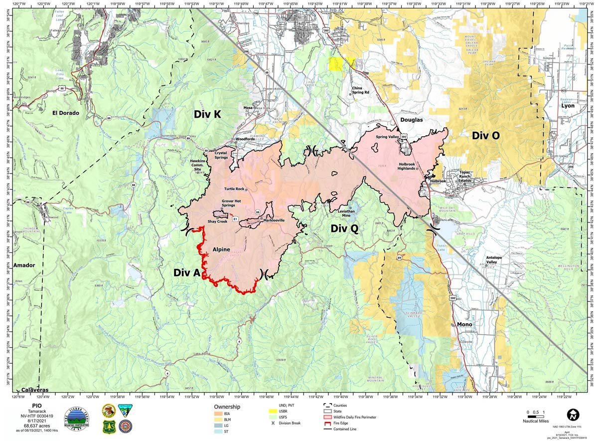
Map for Tuesday, August 17, 2021
Note: 1,200 Pixels Wide
NOTE: Maps represent approximate information.
Evening Update: Gusty northerly winds could increase fire behavior in Div A. Tamarack Fire as of Thursday evening is still at 68,637 Acres with 82% Containment.
Basic Information
| Current as of | 8/18/2021, 5:57:16 PM |
| Incident Type | Wildfire |
| Cause | Lightning |
| Date of Origin | Sunday July 04th, 2021 approx. 04:00 PM |
| Location | 16 Miles south of Gardnerville, NV |
| Incident Commander | Scott Stephenson, IC Tom Raw, Deputy IC |
| Incident Description | This Incident Continues To Be Managed With A Full Suppression Strategy, However Steep Inaccessible Terrain In Division Alpha Necessitates A Suppression Strategy Of Confinement. |
| Coordinates | 38.628 latitude, -119.857 longitude |
Current Situation
| Total Personnel | 265 |
| Size | 68,637 Acres |
| Percent of Perimeter Contained | 82% |
| Estimated Containment Date | Tuesday August 31st, 2021 approx. 12:00 AM |
| Fuels Involved |
Timber (Grass and Understory) Chaparral (6 feet) Timber (Litter and Understory) |
| Significant Events |
Minimal Creeping Smoldering |
Outlook
| Planned Actions |
Divs K & O - Keep fire south of China Spring and west of Highway 395. Keep fire south of Highway 88 and east of Blue Lake Road. Continue right sizing organization. Div K, O and Q in patrol status. Divs A- Keep fire north of Highway 89 (Monitor pass) and Hwy 4. Continue right sizing organization. Hazard tree mitigation in Markleeville and Pleasant Valley areas. |
| Projected Incident Activity |
12 hours: Minimal fire behavior. Gusty northerly winds could increase fire behavior in Div A. 24 hours: Minimal fire behavior. Sunny conditions, gusty winds and low humidities could increase fire behavior. |
| Remarks |
Acreage in Box 7 decreased due to more accurate mapping. Steep rugged terrain in Division Alpha necessitates a suppression strategy of confinement. Perimeter in Division Alpha represents 18% of the total fire perimeter. The remaining perimeter (82%) has been contained. Tamarack fire is assisting with resources on two small fires close to the Tamarack Fire. |
Current Weather
| Weather Concerns |
Red Flag Warning issued for areas west of the fire area but the Tamarack Fire did experience strong gusty winds and dry conditions. Critical fire conditions are possible. Observed: Cooler. Sunny in the morning then widespread smoke and haze by afternoon. Temperatures ranged from 67-81 over the fire area. Minimum RH 15-20%. Winds north to NE 8-15 mph with gusts up to 25 mph in the east part of the fire area. Haines 3. Forecasted: Widespread smoke and haze then clearing. Temps 41-47. Maximum RH 32-37 mid slopes, 45-50% valleys. Northeast to E winds 5-13 mph with gusts to around 25 mph north of Markleeville. Thursday: Sunny. Temps 67-83. RH 18%. Winds variable, NE to S 5-10 mph, gusts 20-25 mph. LAL 1. Haines 3. |
August 19, 2021 - Tamarack Fire Update for Thursday, August 19, 2021. Size: 68,637 acres Containment: 82%
Thursday, August 19, 2021 – 9:00 a.m. Sierra Front Type 3 Incident Management Team 1 Scott Stephenson, Incident Commander Information Phone: 775-434-8629 (public and media) Email: 2021.tamarack@firenet.gov Information Staffing Hours: 8 a.m. to 8 p.m.
Current Situation - Yesterday, the West suppression repair group completed Hazard Tree Mitigation in the Pleasant Valley area. DIV Q spike camp was completely dismantled and the hand crew that it was supporting was demobilized.
Divisions K, O and Q - One engine will continue to patrol these divisions. Division A – Two hand crews and a Wildland Fire Module continue to mop-up in the Mokelumne Wilderness area. The crews continued to be supported by a helicopter for both water drops and supplies. The Wildland Fire Module will remain in the wilderness area for the foreseeable future.
West Suppression Repair Group – Continue Hazard Tree Mitigation in the Thornburg Canyon and Indian Creek Reservoir areas. The Pleasant Valley area will be finished chipping today and resources removed.
Weather and Fuel Conditions – Sunny, with predicted highs of 67-83 degrees, with relative humidity 18%. Winds from the Northeast 5-10 mph, with gusts 20-25 mph. Fuels remain extremely dry.
Closures and Fire Restrictions – Airport rd., leading to Indian Creek res., is closed due to Hazard Tree Mitigation along the road All public lands are closed within the fire’s perimeter, for more information visit: https://www.fs.usda.gov/alerts/htnf/alerts-notices. https://www: .blm.gov/office/carson-city-district-office
Tamarack Fire Statistics: Size: 68,637 acres Containment: 82% Total Personnel: 265 Location: Markleeville, CA Reported: July 4, 2021 Cause: Lightning
For More Information: Public and media information phone: 775-434-8629 Public and media email: 2021.tamarack@firenet.gov InciWeb: https://inciweb.nwcg.gov/incident/7674/ Facebook: www.facebook.com/tamarackfireinfo Twitter: https://twitter.com/tamarack_fire YouTube: https://bit.ly/TamarackVideo Air Now: https://fire.airnow.gov/#
Click here for: Tamarack Fire in Alpine County Updates for Wednesday, August 18, 2021