


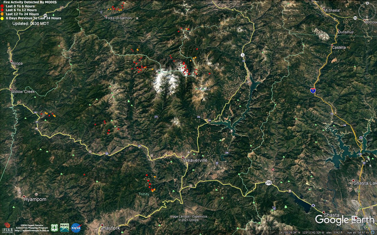
MODIS map of the Monument Fire on Friday at 5:30 A.M PST
Note: 1,200 Pixels Wide - Note: Older Yellow not shown
MODIS Active Fire Mapping Program Frequently Asked Questions
Evening Update: Monument Fire Update for Friday evening, the fire has increased to 142,066 Acres with 16% Containment.
Basic Information
| Current as of | 8/20/2021, 7:59:33 PM |
| Incident Type | Wildfire |
| Cause | Lightning |
| Date of Origin | Friday July 30th, 2021 approx. 06:00 PM |
| Location | Del Loma, CA near Monument Peak |
| Incident Commander | Norm McDonald, Alaska IMT and Mike Parkes, CAL FIRE IMT |
| Incident Description | Wildfire |
| Coordinates | 40.752 latitude, -123.337 longitude |
Current Situation
| Total Personnel | 1,429 |
| Size | 142,066 Acres |
| Percent of Perimeter Contained | 16% |
| Estimated Containment Date | Monday November 01st, 2021 approx. 08:00 AM |
| Fuels Involved |
The fire remains squarely within the 2008 Buckhorn, Eagle, Miners and Cedar Fire footprints. Type converted brush and a heavy dead and down component dominate most areas. Fuels to the north of Hayfork are characterized as widely spaced mixed conifer and grass. All live fuels are cured to levels normally seen in late September. |
| Significant Events |
Fire is fuels driven resulting out of extended and extreme drought with influence of steep slopes and winds. Limited winds resulted in smoke remaining over the fire and created cap over fire with limited fire behavior before the completion of this report on Friday. Elsewhere, fire progression was mostly seen in steeper terrain where backing fire and roll-out allowed the fire to make steady progress. Fire has been chunking away under a cap of smoke and concern exists for increased activity when and if the cap is removed. |
Outlook
| Planned Actions |
Provide structure defense for the communities of Burnt Ranch, Friedrich Road, Cedar Flat and Underwood Mountain. Patrol and mop-up previous firing operations from Highway 299 to DP 59. Patrol and mop-up previous firing operations from DP 59 south to the intersection of the 60 Road and the 47 Road. Defend structures along Corral Bottom Road/47 Road and prodigy site. Monitor fire on north side of the Trinity River around Ironside Mountain. Patrol and secure current fire line around structures within the communities of Don Juan Point east through Big Flat along the Highway 299 corridor. Continue to keep Ironside Mountain Lookout Road open from Ironside Lookout to Highway 299. Monitor the west side of the New River drainage for any spot fires. Scout for opportunities for indirect line north of the New River from Happy Camp Mountain to the confluence of the Trinity River. Prepare structures along the New River from Five Waters northward. Provide structure defense for the communities from Helena east through Junction City and north along Canyon Creek and the East Fork of the North Fork Trinity River. Finish handline from Canyon Creek west to indirect dozer line along ridges around Helena. Continue to prep structures in Canyon Creek. Evaluate options for managing fire to keep from progressing east of the East Fork of the North Fork and impacting values at risk to the east. This may include burning out along the Hobo Gulch Road and further evaluating need for dozer line along Backbone Ridge within the Trinity Alps Wilderness. Hold, mop-up, and patrol fire lines from the Trinity River south to Hocker Meadow. Prep and secure all structures west of Dutch Creek Road. Verify contingency lines north of Highway 3 from Jordan Road to Maxwell Creek Road. Continue firing operations as approved by Operations Section Chief. Strategic Planning meeting scheduled for Saturday with completion of PACE Map with draft Long Term Strategic Analysis. South Zone Planned Operations: Continue with direct, indirect, and contingency line construction and contingency planning. Continue structure protection and working with cooperators to ensure public safety. |
| Projected Incident Activity |
12 hours: Without lifting of smoke, minimal fire behavior is expected. Expect active fire growth in areas where smoke clears under the influence of critically dry fuels with influence of northwesterly flow. High resistance to control. Dry conditions will contribute to the potential for spotting and rapid, uphill runs. Predominant fire spread is anticipated in well aligned drainages on the north side of the Trinity River. Western progression could impact Burnt Ranch and the New River drainage. Within the New River drainage there is potential for slope reversal and progression to the west. 24 hours: Potential for active fire behavior with high resistance to control in areas where smoke clears. Expect burn periods to expand with increased ventilation on the western extent of the fire. Anticipate consistent, but lighter NW winds to develop during the entire burn period to steer established, deep seated fire mostly west along the 299 corridor around Burnt Ranch and the New River drainage, and south towards Hayfork. |
Monument Fire North Zone Update
Resources: 1,583 personnel, 25 hand crews, 128 engines, 11 helicopters, 40 dozers, 30 water tenders, 12 skidgines, 2 excavators.
Current Situation: An infrared flight late Thursday night mapped the entire fire area at 142,250 acres, an increase of almost 6,000 acres over yesterday. Containment remains at 10 percent.
A wind shift is expected over the fire today with winds coming out of the northwest rather than the northeast. The change in wind direction is expected to clear smoke out of the northwest side of the fire. The clearer air will allow more sun to bake the fire, which will likely result in increased activity on the northwest portion of the fire that is most active.
“Expect the (smoke) cap to lift off the west side of the fire today,” Incident Meteorologist Ryan Walbrun said. “The fire will want to stand up.”
Alaska Incident Management Team Fire Behavior Analyst Brad Washa said more sun will definitely impact the fire. “Looking at past large fires in the area, solar radiation is one of the main drivers of fire growth,” he said.
While less smoke means increased fire behavior, it should also allow aircraft to get off the ground so fire managers can get a better look at the fire. Clearer air should also allow the use of helicopters to address areas of concern with water and/or retardant drops.
On Thursday, fire activity picked up on the northwest side north of Burnt Ranch, resulting in an evacuation warning being issued for the communities of Denny, Hawkins Bar and Trinity Village. The fire is backing down Ironside Mountain to the New River east and south of those communities. Fire managers are trying to keep the fire east of the New River so it doesn’t threaten those communities. Helicopter water drops were used Thursday to cool the fire as it backed down the mountain. A similar strategy will be employed today to keep the fire in check.
The number of personnel working on the North and South zones of the fire increased by more than 600 on Thursday as CAL FIRE Incident Management Team 5 mobilized additional crews and engines to the fire. CAL FIRE IMT 5 is managing the South Zone of the fire from Junction City to Hayfork while the Alaska Incident Management Team is managing the North Zone of the Fire from Hayfork to Burnt Ranch to Junction City. The number of hand crews increased from 12 to 25 while the number of engines on the fire jumped by more than 30. An additional 25 dozers were brought in and the number of water tenders increased from 6 to 30.
The Alaska Incident Management Team (North Zone) and CAL FIRE IMT 5 (South Zone) will continue to share resources and prioritize where those resources will focus their efforts.
Today, crews will continue patrolling for spot fires, securing existing control lines, and constructing indirect contingency lines. Crews will continue to clear brush and snags along East Fork Road to open it up for use as a control line, if needed. Crews have made it 3-4 miles up the road and will continue to forge their way north toward Hobo Gulch Road. Crews will also continue to push a dozer line down the Pattison Creek Jeep Trail on the south side of the fire. The goal is to connect the dozer line with a control line being constructed by CAL FIRE IMT 5 west of Hayfork to seal off a chunk of unburned fuel and prevent the fire from moving west toward Hyampom. Once completed, the dozer line could be used as an anchor point for a firing operation, if needed.
Weather: Today’sforecast calls for west winds in the afternoon that should start to clear the air across the west side of the fire. As the inversion breaks this afternoon, fire activity may increase but heavy smoke over the eastern portion of the fire will prevail. Highs in the mid 80s with minimum humidities of 15-25%. Winds will be out of the west at 5-10 mph with gusts of 15 mph.
Road Closures: State Highway 299 is closed between Burnt Ranch and Junction City. Monitor Caltrans's District 2 website (https://dot.ca.gov/caltrans-near-me/district-2).
Evacuation Orders: In effect for Hayfork, Sky Ranch Road, Junction City, Red Hill, Canyon Creek, Coopers Bar, Big Bar, Del Loma, Big Flat, Helena, Cedar Flat, Burnt Ranch and Barker Mountain.
Evacuation Warnings: Ineffect for Weaverville, Douglas City, areas south from Barker Mountain to Haystack, the north side of Hyampom Road from Hayfork to 9-mile bridge, Denny, Hawkins Bar and Trinity Village. For detailed evacuation information, visit the Trinity County Office Sheriff Facebook page at Trinity County Sheriff's Office | Facebook
Evacuation Centers: American Red Cross Shelters have been set up at Shasta College, 11555 Old Oregon Trail, Building 1900, Redding CA; Willow Creek Bible Church, 39 Barannan Mountain Road, Willow Creek, CA; and Fireman’s Hall Pavilion, 9 Park Way in Fortuna.
Animal Evacuation: (Domestic animals) Trinity County Animal Shelter, 563 Mountain View St, Weaverville, CA (530- 623-1370) or (Domestic + Large Animals) Hoopa Rodeo Grounds on Pine Creek Rd, Willow Creek, CA.
Clean Air Centers: Trinity County has established a Clean Air Center at the Trinity County Library, 351 Main Street, Weaverville. Hours are Monday, Wednesday and Friday from 1-6 p.m. and Tuesday and Thursday from 10 a.m. to 6 p.m. The Clean Air Center at the Murray Building at 6641 Highway 3 in Hayfork has been closed due to fire activity.
Property Damage Assessment: Damage assessment teams have confirmed 32 structures have been destroyed. For questions or information regarding the status of your property, call Trinity County Office of Emergency Services (OES) at 530-623-1116.
Forest Closures: Effective August 7, 2021 through October 31, 2021, the Shasta-Trinity Forest has issued Forest Order No. 14-21-21 Monument Fire Closure. Information on the forest order can be found on the Shasta-Trinity National Forest website at Shasta-Trinity NF .
Basic Information
| Current as of | 8/20/2021, 6:50:56 AM |
| Incident Type | Wildfire |
| Cause | Lightning |
| Date of Origin | Friday July 30th, 2021 approx. 06:00 PM |
| Location | Del Loma, CA near Monument Peak |
| Incident Commander | Norm McDonald, Alaska IMT and Mike Parkes, CAL FIRE IMT |
| Incident Description | Wildfire |
| Coordinates | 40.752 latitude, -123.337 longitude |
Current Situation
| Total Personnel | 1,583 |
| Size | 142,250 Acres |
| Percent of Perimeter Contained | 10% |
| Estimated Containment Date | Wednesday September 01st, 2021 approx. 08:00 AM |
| Fuels Involved |
The fire remains squarely within the 2008 Buckhorn, Eagle, Miners and Cedar Fire footprints. Type converted brush and a heavy dead and down component dominate most areas. Fuels to the north of Hayfork are characterized as widely spaced mixed conifer and grass. All live fuels are cured to levels normally seen in late September. |
| Significant Events |
Fire is fuels driven resulting out of extended and extreme drought with influence of steep slopes and winds. Dry, breezy conditions from upper level winds from the Northeast brought active fire behavior to the incident. The northeast winds resulted in lower relative humidities, some areas of clear air with increased solar radiation, and new areas of the fire exposed to winds. Consistent fire spread was observed in all fuel types, but accelerated in lighter fuels with a southwest exposures. Limited overnight fire growth was observed as north winds provided mechanism for southward movement towards Hayfork. Elsewhere, fire progression was mostly seen in steeper terrain where backing fire and roll-out allowed the fire to make steady progress. Fire has been chunking away under a cap of smoke and concern exists for increased activity when the cap is removed. |
Outlook
| Planned Actions |
Provide structure defense for the communities of Burnt Ranch, Friedrich Road, Cedar Flat and Underwood Mountain. Patrol and mop-up previous firing operations from Highway 299 to DP 59. Patrol and mop-up previous firing operations from DP 59 south to the intersection of the 60 Road and the 47 Road. Defend structures along Corral Bottom Road/47 Road and prodigy site. Monitor fire on north side of the Trinity River around Ironside Mountain. Patrol and secure current fire line around structures within the communities of Don Juan Point east through Big Flat along the Highway 299 corridor. Continue to keep Ironside Mountain Lookout Road open from Ironside Lookout to Highway 299. Monitor the west side of the New River drainage for any spot fires. Scout for opportunities for indirect line north of the New River from Happy Camp Mountain to the confluence of the Trinity River. Prepare structures along the New River from Five Waters northward. Provide structure defense for the communities from Helena east through Junction City and north along Canyon Creek and the East Fork of the North Fork Trinity River. Finish handline from Canyon Creek west to indirect dozer line along ridges around Helena. Continue to prep structures in Canyon Creek. Evaluate options for managing fire to keep from progressing east of the East Fork of the North Fork and impacting values at risk to the east. Hold, mop-up, and patrol fire lines from the Trinity River south to Hocker Meadow. Prep and secure all structures west of Dutch Creek Road. Verify contingency lines north of Highway 3 from Jordan Road to Maxwell Creek Road. Continue firing operations as approved by Operations Section Chief. Continue with direct, indirect, and contingency line construction and contingency planning. Continue structure protection and working with cooperators to ensure public safety. |
| Projected Incident Activity |
12 hours: Expect active fire growth under the influence of critically dry fuels with influence of northwesterly flow. High resistance to control. Dry conditions will contribute to the potential for spotting and rapid, uphill runs. Predominant fire spread is anticipated in well aligned drainages on the north side of the Trinity River and from the eastern perimeter towards Junction City. Southern growth will threaten Hayfork, as western progression impacts Burnt Ranch and the New River drainage. Within the New River drainage there is potential for slope reversal and progression to the west. 24 hours: Active fire behavior with high resistance to control. Expect burn periods to expand with increased ventilation. Anticipate consistent, but lighter NW winds to develop during the entire burn period to steer established, deep seated fire mostly west along the 299 corridor towards Burnt Ranch and the New River drainage, and south towards Hayfork. |
| Remarks |
Increase in personnel is due to a more complete capture of CAL FIRE resources. |
Current Weather
| Weather Concerns |
Observed Weather: Heavy smoke laid over the Monument fire for much of today's burn period as North winds brought smoke from the River Complex and McCash fires into the region. The smoke stabilized the fire environment, keeping temperatures slightly cooler with higher humidity values where smoke prevailed through the afternoon. Highs mid 70s to mid 80s with afternoon humidity 20-30%. Northerly winds kept smoke plumes pushing southward while winds at the surface remained fairly light. Forecast Weather: Smoke will lay over the fire again tonight with stable and quiet weather as winds ease. Humidity recovery will be moderate from 45-65% most locations with temperatures in the mid 50s to mid 60s overnight. On Friday the forecast calls for some West winds in the afternoon that should start to clear the air across the West side of the fire in Division A and E. As the inversion breaks Friday afternoon fire activity may increase but heavy smoke over the eastern portions of the fire will prevail. Highs in the mid 80s with minimum humidity 15-25%. West winds 5-10 mph gusts 15 mph. |
Click here for: California Monument Fire Thursday, August 19, 2021 Updates
