


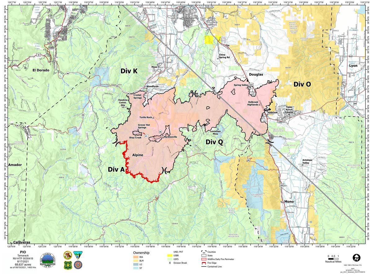
Map for Tuesday, August 17, 2021
Note: 1,200 Pixels Wide
NOTE: Maps represent approximate information.
Evening Update: Minimal fire behavior. Minimal risk of ember cast from Caldor Fire due to SW to W winds. Tamarack Fire as of Friday evening is still at 68,637 Acres with 82% Containment.
Basic Information
| Current as of | 8/20/2021, 5:30:15 PM |
| Incident Type | Wildfire |
| Cause | Lightning |
| Date of Origin | Sunday July 04th, 2021 approx. 04:00 PM |
| Location | 16 Miles south of Gardnerville, NV |
| Incident Commander | Scott Stephenson, IC Tom Raw, Deputy IC |
| Incident Description | This Incident Continues To Be Managed With A Full Suppression Strategy, However Steep Inaccessible Terrain In Division Alpha Necessitates A Suppression Strategy Of Confinement. |
| Coordinates | 38.628 latitude, -119.857 longitude |
Current Situation
| Total Personnel | 229 |
| Size | 68,637 Acres |
| Percent of Perimeter Contained | 82% |
| Estimated Containment Date | Tuesday August 31st, 2021 approx. 12:00 AM |
| Fuels Involved |
Timber (Grass and Understory) Chaparral (6 feet) Timber (Litter and Understory) |
| Significant Events |
Minimal Creeping Smoldering |
Outlook
| Planned Actions |
Divs K & O - Keep fire south of China Spring and west of Highway 395. Keep fire south of Highway 88 and east of Blue Lake Road. Continue right sizing organization. Div K, O and Q in patrol status. Divs A- Keep fire north of Highway 89 (Monitor pass) and Hwy 4. Continue right sizing organization. Hazard tree mitigation in Markleeville and Pleasant Valley areas completed. Hazard mitigation on Hot Springs road and Indian Creek campground continues. |
| Projected Incident Activity |
12 hours: Minimal fire behavior. Minimal risk of ember cast from Caldor Fire due to SW to W winds. 24 hours: Minimal fire behavior. Widespread haze and smoke after 11 am. After haze clears wind gusts up to 40 mph in the northern and eastern part of the fire could increase fire behavior. |
| Remarks |
Acreage in Box 7 decreased due to more accurate mapping. Steep rugged terrain in Division Alpha necessitates a suppression strategy of confinement. Perimeter in Division Alpha represents 18% of the total fire perimeter. The remaining perimeter (82%) has been contained. Tamarack fire is assisting with resources on two small fires close to the Tamarack Fire. |
Current Weather
| Weather Concerns |
After a cool start, high temperature will return to more typical values today. Winds were light and slope driven early today, increasing and becoming westerly by late afternoon. This will likely bring return of smoke and haze from other ongoing fires. Stronger WSW winds are possible Saturday as another cold front tracks through the region, however, speeds are expected to be weaker than earlier in the week. Observed: Widespread smoke and haze, sunny. Temperatures in the 80's. Average relative humidity 19%. Upslope winds 3-7 mph became SW 9-14 mph late in the afternoon. Haines 3. Forecasted: Tonight clear, smoke and haze developing in the evening. Temperature high 40's to low 50's. West winds 10-20 mph becoming SW with gusts 25-30 mph. Relative humidity to 50% |
August 20, 2021 - Tamarack Fire Update for Friday, August 20, 2021. Size: 68,637 acres with Containment: at 82%.
Sierra Front Type 3 Incident Management Team 1
Scott Stephenson, Incident Commander
Information Phone: 775-434-8629 (public and media)
Email: 2021.tamarack@firenet.gov
Information Staffing Hours: 8 a.m. to 8 p.m.
Current Situation: Yesterday, the West suppression repair group completed Hazard Tree Mitigation in the Pleasant Valley area. Residents in the Markleeville area as well as along Hwy 89 will continue to see heavy truck traffic. DIV Q spike camp was completely dismantled and the hand crew that it was supporting was demobilized. On Monday August 23, Sierra Front Incident Management Team 1 will be transferring command of the Tamarack Fire to a local Type 4 organization.
West Repair Group - Continue Hazard Tree Mitigation in the Thornburg Canyon and Indian Creek Reservoir areas.
Divisions K, O and Q – One engine will continue to patrol these divisions.
Division A - A Wildland Fire Module will continue to mop-up in the Mokelumne Wilderness area. The module will continue to be supported by a helicopter for both water drops and supplies. The Wildland Fire Module will remain in the wilderness area for the foreseeable future.
Weather and Fuel Conditions: Sunny, with predicted high around 82 degrees, with relative humidity 19%. Upslope winds 3-7 mph becoming southwest 9-14 mph late in the afternoon. Fuels remain extremely dry.
Closures, and Fire Restrictions: – Airport road, leading to Indian Creek reservoir, is closed due to Hazard Tree Mitigation along the road.
All public lands are closed within the fire’s perimeter, for more information visit: https://www.fs.usda.gov/alerts/htnf/alerts-notices. https://www: .blm.gov/office/carson-city-district-office
Tamarack Fire Statistics: Size: 68,637 acres Containment: 82% Total Personnel: 262 Location: Markleeville, CA Reported: July 4, 2021 Cause: Lightning
Click here for: Tamarack Fire in Alpine County Updates for Thursday, August 19, 2021
