


Update: Caldor Fire Virtual Briefing & Community Meeting Evening Update Video for Sunday, August 22, 2021
Evening Update Per CAL FIRE: California Caldor Fire is at 104,309 Acres, with 5% Containment, and 1,618 personnel assigned for Sunday evening.
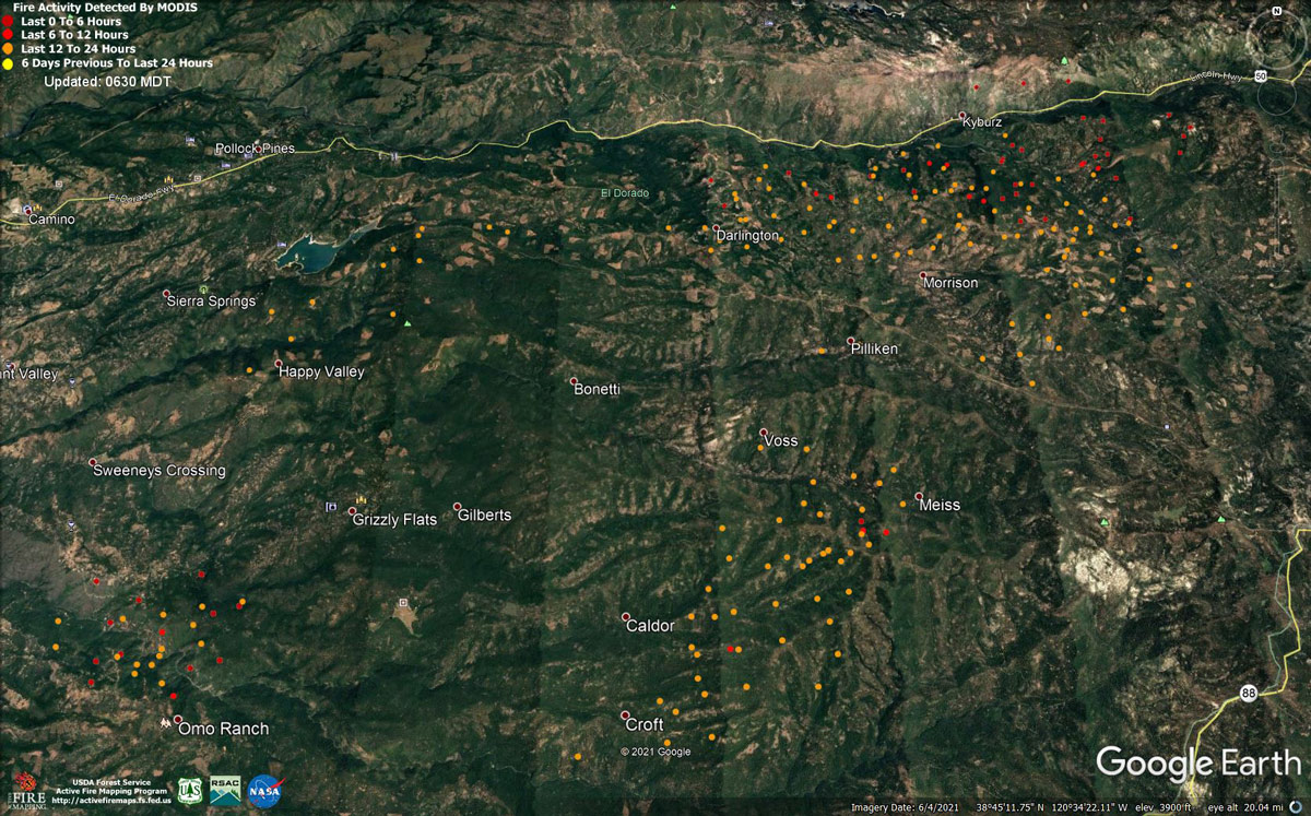
MODIS map of the Caldor Fire on Sunday at 5:30 A.M PST
Note: 1,200 Pixels Wide - Note: Older Yellow not shown
MODIS Active Fire Mapping Program Frequently Asked Questions
Update: Caldor Fire Online Structure Damage Map Now Available
Update: Caldor Fire Operations Briefing Update Video for Sunday, August 22, 2021
Update: Caldor Fire Virtual Community Meeting Set for 5:00 P.M. Tonight, August 22, 2021
Update: Smoke/Air Quality Outlook for the California Caldor Fire for Sunday, August 22, 2021
August 22, 2021 - Caldor Fire Update for Sunday Morning, 98,149 acres.Basic Information
| Current as of | 8/22/2021, 6:56:11 AM |
| Incident Type | Wildfire |
| Cause | Under Investigation |
| Date of Origin | Saturday August 14th, 2021 approx. 07:00 PM |
| Location | 4 miles South of Grizzly Flats, 2 miles East of Omo Ranch |
| Incident Commander | CAL FIRE AEU, USDA Forest Service – Eldorado National Forest |
| Incident Description | Online Community Meeting 5:00 - 5:30 Pm Https://www.facebook.com/calfireaeu/. Summary: The Fire Remained Active In All Areas Overnight With Short-range Spotting And Rollout Continuing To Increase The Fire Perimeter. Winds Decreased During The Evening Hours And Returned To A Southerly Flow Allowing For Continued Growth In The Northeastern Areas Of The Fire. Due To Very Dry Receptive Fuel Beds, The Vegetation Is Igniting Easily Throughout The Fire Area. The Increase Of Relative Humidity Allowed For Firing Operations To Help Strengthen Control And Containment Lines. With Historic Drought Conditions There Is Heavy Dead And Down Fuels Throughout The Fire Area. Northern California Remains Under Fuels And Fire Behavior Advisory. Due To Ongoing Damage Assessment Of The Area The Numbers Of Destroyed And Damaged Structures Are Subject To Change. To Better Provide Public And Firefighter Safety Due To Extreme Fire Conditions Throughout Northern California, And Strained Firefighter Resources Throughout The Country, The Usda Forest Service Pacific Southwest Region Is Announcing A Temporary Closure Of Nine National Forests. This Closure Will Be Effective On August 22, 2021, At 11:59 P.m. Through September 6, 2021, At 11:59 P.m. The Closure Order Can Be Found At Https://go.usa.gov/xf7em Please Register For Codered Through The Local County Sheriff’s Office El Dorado County Code Red: Https://ready.edso.org/ Amador County Codered: Https://www.amadorsheriff.org/administration-division/codered |
| Coordinates | 38.584 latitude, -120.534 longitude |
Current Situation
| Total Personnel | 1,603 |
| Size | 98,149 Acres |
| Estimated Containment Date | Tuesday August 31st, 2021 approx. 12:00 AM |
| Fuels Involved |
Heavy timber. Steep terrain. |
| Significant Events |
EL DORADO COUNTY MANDATORY EVACUATIONS ORDERS: - Grizzly Flat: The areas on Grizzly Flats Road east of Kendra Way into Grizzly Flats Proper. The areas of Diamond Railroad Grade, Old School House, Sweeney Road, Caldor Road, and steely Ridge. • Grizzly Flats Road east of four corners in Somerset into Grizzly Flats Proper. - The areas of Myers Lane, Varmet Ridge Road, Rodwell Canyon Road, Snowbird Lane, and Mehwald Lane. • East of Sly Park Road between Highway 50 and Mormon Emigrant Trail to Ice House Road. This includes the communities of Pacific House and Fresh Pond. • North of Highway 50 ,east of Forebay Road to Ice House Road. • Intersection of Perry Creek and Hawk Haven , the East side of Fairplay Road from Perry Creek South to Cedarville Road. This includes Slug Gulch, Omo Ranch, and all roads off of Slug Gulch and Omo Ranch. • All roads off of Omo Ranch from Cedarville Road to Hwy 88. • The area between Highway 88 and Mormon Emigrant Trail • South of Highway 50 from Snows Road to Ice House Road. • Between Highway 50 and Slab Creek from Snows Road to Ice House Road. - South of Highway 50 from Ice House Road to Silver Fork Road. This includes the community of Kyburz. • North of Highway 50 from Ice House Road to Silver Fork Road to include Ice House Reservoir, Union Valley Reservoir, and Loon Lake. EVACUATION WARNINGS: -North of Slab Creek to Wentworth Springs Road between Sand Mountain and Loon Lake. • Mosquito Road from the bridge North to include the Community of Swansboro. • North of Highway 50 to Slab Creek between Smith Flat and Snows Road. • South of Highway 50 to Pleasant Valley between Smith Flat and Snows Road, and North of Pleasant Valley between Holm and Newtown. • South of Pleasant Valley between Bucks Bar Road and Newtown Road, East of Bucks Bar Road to Mt Aukum Road. • Southwest of Bucks Bar Road to Ladies Valley Road including the community of Outingdale, Ant Hill Road, Perry Creek Road and Sand Ridge between Ladies Valley Road and Bucks Bar Road. • East of Mt Aukum Road (E16) from Bucks Bar Road to Omo Ranch Road. North of Omo Ranch Road to the intersection of Omo Ranch Road and Fairplay Road. • South of Omo Ranch to the El Dorado County Line between Mt Aukum Road (E16) and Fairplay Road to include Coyoteville Road, Cedar Creek and all tributary roads. • North of Slab Creek to Wentworth Springs Road between Sand Mountain and Loon Lake. • Mosquito Road from the bridge North to include the Community of Swansboro. • North of Highway 50 to Slab Creek between Smith Flat and Snows Road. • Silver Fork Road in Kyburz east to Twin Bridges. • North and south in a line extending from Twin Bridges to the Placer County line and south to the Amador County line. AMADOR COUNTY - EVACUATION WARNINGS - Shenandoah Road at the Amador County line west through the River Pines community, continuing west on Shenandoah Road to Ostrom Road. South on Ostrom Road to Jibboom Street, West on Jibboom Street to Fiddletown Road. East on Fiddletown Road to Hale Road. South on Hale Road to Shake Ridge Road. East on Shake Ridge Road to Charleston Road. South on Charleston Road to the intersection of Charleston Road and Rams Horn Grade. Due east to Highway 88 at Tiger Creek Road. Tiger Creek Road east to Salt Springs Reservoir Road. East on Salt Springs Reservoir Road to the east end of the Salt Springs Reservoir. Due north from the east end of Salt Springs Reservoir to Highway 88. - South of the El Dorado-Amador County line with a western border of Highway 88 due south to the east end of Salt Springs Reservoir. Southern border of the Calaveras County line. Eastern border of the Alpine County line. SHELTER INFORMATION: - Shelter Green Valley Community Church 3500 Missouri Flat Road Placerville, CA - Shelter- FULL Cameron Park CSD 2502 Country Club Drive Cameron Park, CA - Temporary Evacuation Point Amador County Fairgrounds 18621 Sherwood Street Plymouth, CA - Shelter Evelynn Bishop Hall 701 Hwy 124 Ione, CA 855-755-7711 - Shelter Rolling Hills Church 800 White Rock Road El Dorado Hills, CA ANIMAL EVACUATION INFORMATION: - El Dorado County Animal Services (small animals) 6435 Capitol Ave. Diamond Springs, CA For animal evacuation questions or assistance call (530) 621-5795 - Saureel Vineyards (large animals) 1140 Cold Springs Road Placerville, CA (530) 621-5795 - Amador County Fairgrounds (large animal)- FULL 18621 Sherwood Street Plymouth, CA |
Outlook
| Projected Incident Activity |
Current Weather
| Weather Concerns |
A Red Flag Warning is in effect from 11 AM through 8 PM Saturday for Strong Winds and Low Humidity. Observed: Winds picked up from the south in the morning and increased in speed, becoming southwest by mid-day. Inversion conditions broke by 1000 am winds reached sustained speeds of 10-15 mph with gusts to as high as 30 mph at exposed ridge tops. These winds will continue through sunset. Temperatures rose into the 65-75 degree range with relative humidity minimums in the 30-35 percent range in the upper elevations of the fire while the 45-55 percent range was common on the lower elevation west side of the fire as marine air from the coast spread into these lower elevations. Forecast for tonight: Mostly clear with areas of smoke. Lows 50-60. Humidity recovery 55-60 percent. Southwest winds diminishing in the early evening and becoming downslope (easterly) 2-6 mph. |
Click here for: California Caldor Fire Saturday, August 21, 2021 Updates
