


Evening Update: Monument Fire Update for Monday evening, the fire has increased to 150,011 Acres with 20% Containment and 1,798 total personnel.
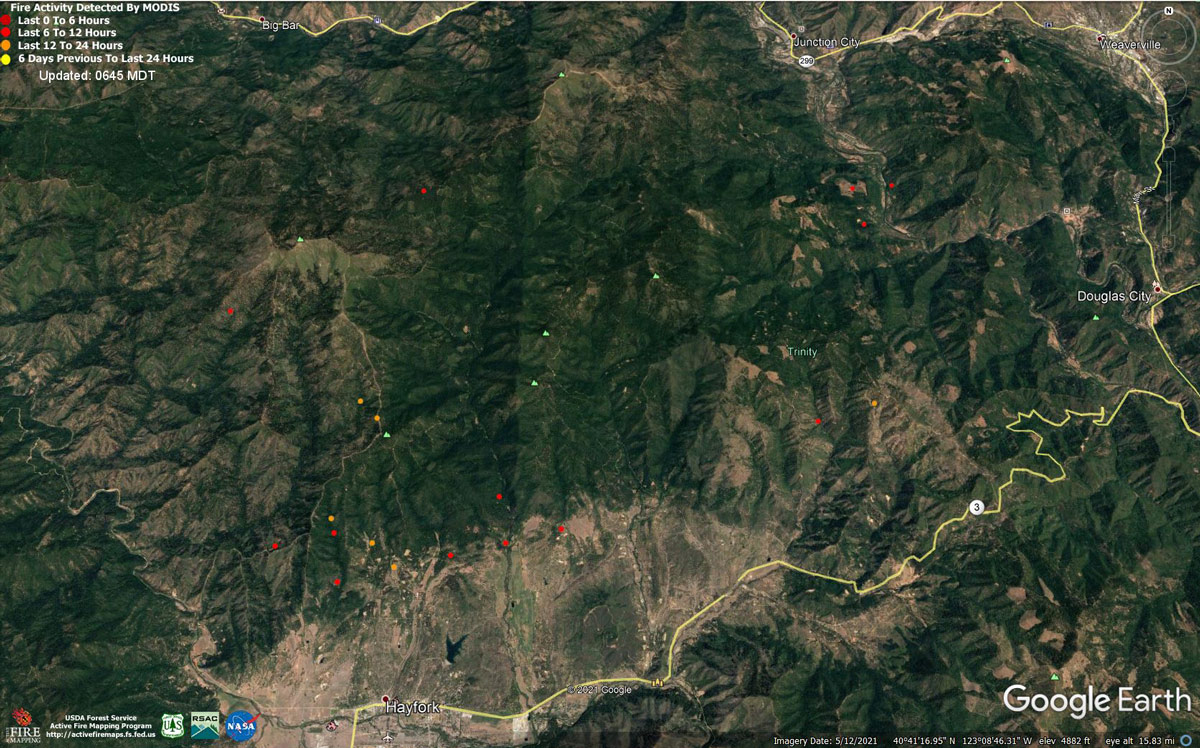
MODIS map of the Monument Fire on Monday at 5:45 A.M PST
Note: 1,200 Pixels Wide - Note: Older Yellow not shown
MODIS Active Fire Mapping Program Frequently Asked Questions
Update: Trinity County Sheriff's Office Issues an Evacuation Order for the Monument Fire on August 23, 2021
Updated 3:00 P.M.: Monument Fire Updates - Evacuation Orders Reduced to Evacuation Warnings
August 23, 2021 - Monument Fire Update for Monday Morning, 150,011 acres with 20% containment.
Basic Information
| Current as of | 8/23/2021, 6:24:58 AM |
| Incident Type | Wildfire |
| Cause | Lightning |
| Date of Origin | Friday July 30th, 2021 approx. 06:00 PM |
| Location | Del Loma, CA near Monument Peak |
| Incident Commander | Norm McDonald, Alaska IMT and Mike Parkes, CAL FIRE IMT |
| Incident Description | Wildfire |
| Coordinates | 40.752 latitude, -123.337 longitude |
Current Situation
| Total Personnel | 1,725 |
| Size | 150,011 Acres |
| Percent of Perimeter Contained | 20% |
| Estimated Containment Date | Monday November 01st, 2021 approx. 08:00 AM |
| Fuels Involved |
The fire remains squarely within the 2008 Buckhorn, Eagle, Miners and Cedar Fire footprints. Type converted brush and a heavy dead and down component dominate most areas. Fuels to the north of Hayfork are characterized as widely spaced mixed conifer and grass. All live fuels are cured to levels normally seen in late September. |
| Significant Events |
Fire is fuels driven resulting out of extended and extreme/enhanced drought with influence of steep slopes and winds. The spot fire that occurred over the past 2 days in the western heal of the fire continued to be resistant to control. Flanking and backing fires consumed all surface fuels with moderate flame lengths and rates of spread. Minimal surface wind allowed smoke to remain over the majority of the fire and created a cap which has limited fire behavior. Additionally, as fire has reached lighter fuels on the southeast flank, increased rates of spread and higher flame lengths have occurred. Moderate overnight RH recovery has been consistent for past 3 nights. Fire has been chunking away under a cap of smoke and concern exists for increased activity when and if the cap is removed within other parts of the fire. |
Outlook
| Planned Actions |
Provide structure defense for the communities of Burnt Ranch, Friedrich Road, Cedar Flat and Underwood Mountain. Patrol and mop-up along Corral Bottom Road/47 Road and prodigy site. Monitor fire on north side of the Trinity River around Ironside Mountain. Patrol and secure current fire line around structures within the communities of Don Juan Point east through Big Flat along the Highway 299 corridor. Monitor the west side of the New River drainage for any spot fires. Scout for opportunities for indirect line north of the New River from Happy Camp Mountain to the confluence of the Trinity River. Take action on all spots across west of the New River. Prepare structures along the New River from Five Waters northward. Provide structure defense for the communities from Helena east through Junction City and north along Canyon Creek and the East Fork of the North Fork Trinity River. Finish handline from Canyon Creek west to indirect dozer line along ridges around Helena. Continue to prep structures in Canyon Creek. Evaluate options for managing fire to keep from progressing east of the East Fork of the North Fork and impacting values at risk to the east. This may include burning out along the Hobo Gulch Road and further evaluating need for dozer line along Backbone Ridge within the Trinity Alps Wilderness. Hold, mop-up, and patrol fire lines from the Trinity River south to Hocker Meadow. Prep and secure all structures west of Dutch Creek Road. Verify contingency lines north of Highway 3 from Jordan Road to Maxwell Creek Road. Continue firing operations as approved by Operations Section Chief. South Zone Planned Operations: Continue with direct, indirect, and contingency line construction. Continue structure protection and working with cooperators to ensure public safety. |
| Projected Incident Activity |
12 hours: Limited active fire growth will be seen only in areas where smoke clears. All fuels remain critically dry and ERCs reduced slightly over the past 3 days but will remain above the 90th percentile. High resistance to control is being realized on spot fires and slop-overs. Dry conditions will contribute to the potential for spotting and rapid, uphill runs. Fire spread is anticipated in well aligned east/west drainages under clear well-ventilated conditions. Within the New River drainage there is potential for slope reversal and progression to the west. Without the lifting of smoke, minimal fire behavior is expected on the eastern end of the fire. 24 hours: There is potential for active fire behavior with high resistance to control in areas where smoke clears. Expect fire behavior to remain limited to ridgetops and drainages that develop strong updrainage winds with increased ventilation on the western and southern fringes of the fire. Smoke cover is expected to influence the entire fire for the entire burn period and severely limit ventilation and growth potential. |
Current Weather
| Weather Concerns |
Observed Weather: Heavy smoke blanketed the fire today under light, terrain driven winds. Low temperatures ranged in the mid 50s with good humidity recovery of 60-80% for most locations this morning. A light east-southeast ridge level wind developed after midnight which dropped humidity across ridges through sunrise to 45-50%. Under smoky and sun filtered skies temperatures rose into the upper 70s to mid 80s through the afternoon with some ridgetops warming to near 70. Ridge level winds transitioned to WSW to WNW into the afternoon. Peak wind gusts neared 15 mph in the Trinity River Basin in the late afternoon and early evening. Minimum humidity ranged from near 20 to 30%. Forecast Weather: Smoke will settle across the fire again tonight with minimum temperatures ranging in the 50s to near 60 in thermal belts. Moderate humidity recovery will continue across lower elevations with maximum values of 50-70%, but ridges will dry after midnight into the 35-45% range through sunrise as weak easterly winds develop. Monday Outlook: Widespread, persistent smoke will continue under terrain driven winds. Temperatures will be slightly warmer and minimum humidity a little lower, with highs in the upper 70s to near 90 across most of the fire. Highs may only reach the low 70s across ridges under smoke. Minimum humidity will range from the upper teens to near 30%. Up-canyon winds develop mid to late afternoon with peak gusts near 15 mph. |
Click here for: California Monument Fire Sunday, August 22, 2021 Updates
