


Note: Click here for Sunday Updates:
California Caldor Fire Sunday, August 29, 2021 Updates
Update: Caldor Fire Virtual Briefing & Community Meeting Evening Update Video for Saturday, August 28, 2021
Evening Update Per CAL FIRE: California Caldor Fire is at 152,545 Acres, with 19% Containment, and 3,352 personnel assigned for Saturday evening.
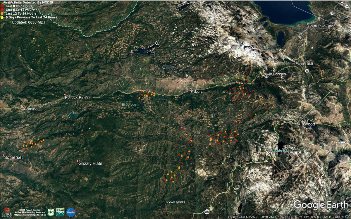
MODIS map of the Caldor Fire on Saturday at 5:30 A.M PST
Note: 1,200 Pixels Wide - Note: Older Yellow not shown
MODIS Active Fire Mapping Program Frequently Asked Questions
Update: CAL FIRE Shows How Forest Fuel Treatments Can Influence Fire Effects on the Landscape (with Videos)
Update: Smoke/Air Quality Outlook for the California Caldor Fire for Saturday, August 28, 2021
Update: California Caldor Fire Infrared Map for Saturday, August 28, 2021
August 28, 2021 - Caldor Fire Update for Saturday Morning, 149,684 Acres with 19% Containment.
CAL FIRE
Click' here to view full PDF
Basic Information
| Current as of | 8/28/2021, 7:14:06 AM |
| Incident Type | Wildfire |
| Cause | Under Investigation |
| Date of Origin | Saturday August 14th, 2021 approx. 07:00 PM |
| Location | 4 miles South of Grizzly Flats, 2 miles East of Omo Ranch |
| Incident Commander | Jeff Veik, CAL FIRE IMT6 Joe Reinarz, USFS NIMO 2 |
| Incident Description | ONLINE COMMUNITY MEETING 5:00 - 5:30 PM https://www.facebook.com/CALFIREAEU/. SUMMARY: The nighttime inversion layer returned bringing a reduction in fire spread, spotting, and visibility. Down-canyon winds and low humidity increased fire activity in Division D. Firing operations continued in the Eastern flanks, while firefighters took advantage of the slow easterly winds to improve control lines. Terrain continues to be challenging for fire crews throughout the fire. Damage inspection teams continue to inspect properties and infrastructure throughout the area. FOREST CLOSURE: To better provide public and firefighter safety due to extreme fire conditions throughout Northern California, and strained firefighter resources throughout the Country, the USDA Forest Service Pacific Southwest Region is announcing a temporary closure of nine National Forests. This closure will be effective on August 22, 2021, at 11:59 p.m. through September 6, 2021, at 11:59 p.m. The closure order can be found at https://tinyurl.com/USFSClosure. LOCAL AREA ASSISTANCE: Address: 6699 Campus Drive, Placerville, CA 95667. Located at Folsom Lake Community College, El Dorado Campus, Fitness Center Building. Hours: Monday through Friday 10:00 a.m. to 5:00 p.m., Wednesdays 1:00 p.m. to 7:00 p.m. CODE RED: Please register for CodeRED through the local County Sheriff’s Office El Dorado County Code Red: https://ready.edso.org/ Amador County CodeRED: https://www.amadorsheriff.org/administration-division/codered |
| Coordinates | 38.584 latitude, -120.534 longitude |
Current Situation
| Total Personnel | 3,302 |
| Size | 149,684 Acres |
| Percent of Perimeter Contained | 19% |
| Estimated Containment Date | Wednesday September 08th, 2021 approx. 06:00 PM |
| Fuels Involved |
Heavy timber. Steep terrain. |
| Significant Events |
EL DORADO COUNTY MANDATORY EVACUATIONS ORDERS: • Grizzly Flat: The areas on Grizzly Flats Road east of Kendra Way into Grizzly Flats Proper. The areas of Diamond Railroad Grade, Old School House, Sweeney Road, Caldor Road, and Steely Ridge. • Grizzly Flats Road east of four corners in Somerset into Grizzly Flats Proper. • The areas of Myers Lane, Varmet Ridge Road, Rodwell Canyon Road, Snowbird Lane, and Mehwald Lane. • East of Sly Park Road between Highway 50 and Mormon Emigrant Trail to Ice House Road. This includes the communities of Pacific House and Fresh Pond. • North of Highway 50, east of Forebay Road to Ice House Road. • Intersection of Perry Creek and Hawk Haven , the East side of Fairplay Road from Perry Creek South to Cedarville Road. This includes Slug Gulch, Omo Ranch, and all roads off of Slug Gulch and Omo Ranch. • All roads off of Omo Ranch from Cedarville Road to Hwy 88. • The area between Highway 88 and Mormon Emigrant Trail • South of Highway 50 from Snows Road to Ice House Road. • Between Highway 50 and Slab Creek from Snows Road to Ice House Road. • South of Highway 50 from Ice House Road to Silver Fork Road. This includes the community of Kyburz. • North of Highway 50 from Ice House Road to Silver Fork Road to include Ice House Reservoir, Union Valley Reservoir, and Loon Lake. • From Twin Bridges east to Echo Summit, then from Highway 50 South to Amador/Alpine County line and from Highway 50 North to Flag Pole Peak. EVACUATION WARNINGS: • North of Slab Creek to Wentworth Springs Road between Sand Mountain and Loon Lake. • Mosquito Road from the bridge North to include the Community of Swansboro. • North of Highway 50 to Slab Creek between Smith Flat and Snows Road. • South of Highway 50 to Pleasant Valley between Smith Flat and Snows Road, and North of Pleasant Valley between Holm and Newtown. • South of Pleasant Valley between Bucks Bar Road and Newtown Road, East of Bucks Bar Road to Mt Aukum Road. • Southwest of Bucks Bar Road to Ladies Valley Road including the community of Outingdale, Ant Hill Road, Perry Creek Road and Sand Ridge between Ladies Valley Road and Bucks Bar Road. • East of Mt Aukum Road (E16) from Bucks Bar Road to Omo Ranch Road. North of Omo Ranch Road to the intersection of Omo Ranch Road and Fairplay Road. • South of Omo Ranch to the El Dorado County Line between Mt Aukum Road (E16) and Fairplay Road to include Coyoteville Road, Cedar Creek and all tributary roads. • North of Slab Creek to Wentworth Springs Road between Sand Mountain and Loon Lake. • Mosquito Road from the bridge North to include the Community of Swansboro. • North of Highway 50 to Slab Creek between Smith Flat and Snows Road. AMADOR COUNTY - EVACUATION WARNINGS • Shenandoah Road at the Amador County line west through the River Pines community, continuing west on Shenandoah Road to Ostrom Road. South on Ostrom Road to Jibboom Street, West on Jibboom Street to Fiddletown Road. East on Fiddletown Road to Hale Road. South on Hale Road to Shake Ridge Road. East on Shake Ridge Road to Charleston Road. South on Charleston Road to the intersection of Charleston Road and Rams Horn Grade. Due east to Highway 88 at Tiger Creek Road. Tiger Creek Road east to Salt Springs Reservoir Road. East on Salt Springs Reservoir Road to the east end of the Salt Springs Reservoir. Due north from the east end of Salt Springs Reservoir to Highway 88. • South of the El Dorado-Amador County line with a western border of Highway 88 due south to the east end of Salt Springs Reservoir. Southern border of the Calaveras County line. Eastern border of the Alpine County line. • Christmas Valley from Highway 89 West to Echo Summit. • Highway 89 due West to Watershed Ridge and South to the Amador/El Dorado County line. ALPINE COUNTY - EVACUATION WARNINGS • Highway 89 South from Luther Pass Road to the Pickets Junction (Highway 88). • West on Highway 88 to Kirkwood. SHELTER INFORMATION: • Shelter Green Valley Community Church 3500 Missouri Flat Road Placerville, CA • Shelter- Cameron Park CSD 2502 Country Club Drive Cameron Park, CA • Shelter Rolling Hills Church 800 White Rock Road El Dorado Hills, CA AMADOR COUNTY • Temporary Evacuation Point Amador County Fairgrounds 18621 Sherwood Street Plymouth, CA • Shelter Evelynn Bishop Hall 701 Hwy 124 Ione, CA 855-755-7711 NEVADA • Shelter Douglas County Community Center 1329 Waterloo Lane Gardnerville, NV ANIMAL EVACUATION INFORMATION: • El Dorado County Animal Services (small animals) 6435 Capitol Ave. Diamond Springs, CA For animal evacuation questions or assistance call (530) 621-5795 • Saureel Vineyards (large animals) 1140 Cold Springs Road Placerville, CA (530) 621-5795 • Amador County Animal Response Team- ACART Amador County Fairgrounds (large animal)- 18621 Sherwood Street Plymouth, CA For Amador County residents only (209) 257-9444 |
Outlook
| Projected Incident Activity |
Current Weather
| Weather Concerns |
Observed: Widespread smoke and inversion conditions prevailed through most of the day. It was warmer and drier over much of the fire with highs ranging from around 90 over the lower elevations to the lower 70s at the highest elevations on the east side. Relative humidity was very low with minimum values of 10-17 percent common. Winds remained down-canyon gusting to as much as 15 mph through mid-morning then upslope and up-canyon winds developed and gusted to around 18 mph by mid-afternoon. Forecast for tonight: Mostly clear with areas of smoke. Lows 60-70. Humidity recovery will be poor in the 20-25 percent range. Winds downslope (easterly) 2-6 mph but stronger and gusty through and below major drainages. |
Click here for: California Caldor Fire Friday, August 27, 2021 Updates
