


Click here for Monday's Updates
California Caldor Fire Monday, August 30, 2021 Updates
NEW Update: Caldor Fire Updates to Evacuation Orders, Warnings, and Road Closures for Sunday, August 29, 2021
Update: Caldor Fire Virtual Briefing & Community Meeting Evening Update Video for Sunday, August 29, 2021
Evening Update Per CAL FIRE: California Caldor Fire is at 168,387 Acres, with 13% Containment, and 3,531 personnel assigned for Sunday evening.
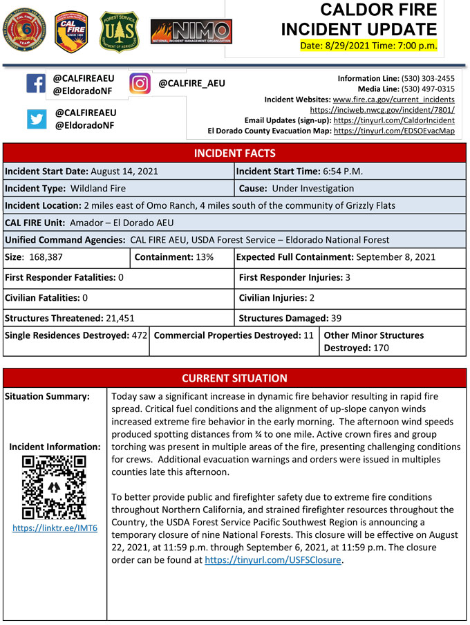

MODIS map of the Caldor Fire on Sunday at 5:15 A.M PST
Note: 1,200 Pixels Wide - Note: Older Yellow not shown
MODIS Active Fire Mapping Program Frequently Asked Questions
Update: Caldor Fire Updates to Evacuation Orders, Warnings, and Road Closures for Sunday, August 29, 2021
Update: Caldor Fire Virtual Community Meeting Set for 5:00 P.M. Tonight, August 29, 2021
Update: Caldor Fire Operations Briefing Video for Sunday Morning, August 29, 2021
Update:Smoke/Air Quality Outlook for the California Caldor Fire for Sunday, August 29, 2021
Update: California Caldor Fire Infrared Map for Sunday, August 29, 2021
August 29, 2021 - Caldor Fire Update for Sunday Morning, 156,515 Acres with 19% Containment.
Update CAL FIRE
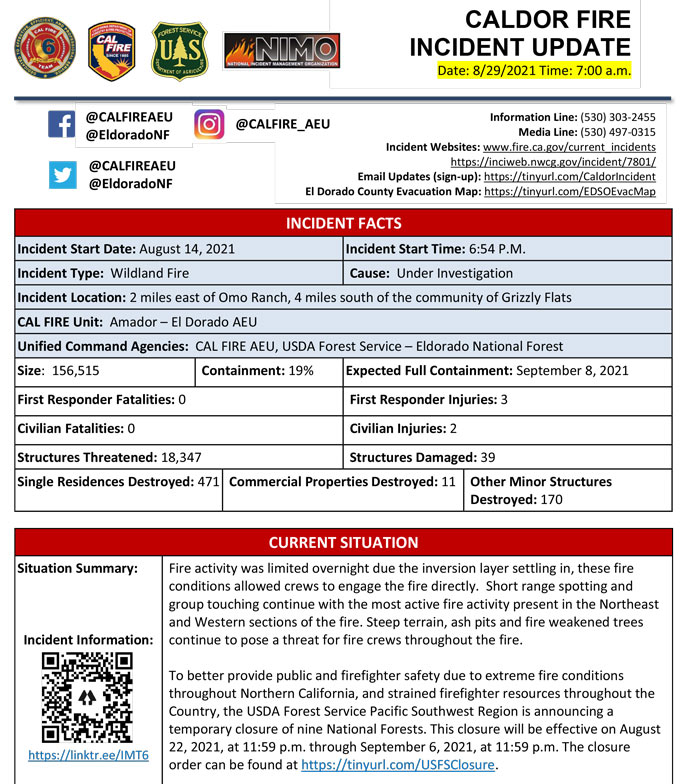
Basic Information
| Current as of | 8/29/2021, 7:07:16 AM |
| Incident Type | Wildfire |
| Cause | Under Investigation |
| Date of Origin | Saturday August 14th, 2021 approx. 07:00 PM |
| Location | 4 miles South of Grizzly Flats, 2 miles East of Omo Ranch |
| Incident Commander | Jeff Veik, CAL FIRE IMT6 Joe Reinarz, USFS NIMO 2 |
| Coordinates | 38.584 latitude, -120.534 longitude |
Current Situation
| Total Personnel | 3,531 |
| Size | 156,515 Acres |
| Percent of Perimeter Contained | 19% |
| Estimated Containment Date | Wednesday September 08th, 2021 approx. 06:00 PM |
| Fuels Involved |
Heavy timber. Steep terrain. |
| Significant Events |
EL DORADO COUNTY MANDATORY EVACUATIONS ORDERS: • Grizzly Flat: The areas on Grizzly Flats Road east of Kendra Way into Grizzly Flats Proper. The areas of Diamond Railroad Grade, Old School House, Sweeney Road, Caldor Road, and Steely Ridge. • Grizzly Flats Road east of four corners in Somerset into Grizzly Flats Proper. • The areas of Myers Lane, Varmet Ridge Road, Rodwell Canyon Road, Snowbird Lane, and Mehwald Lane. • East of Sly Park Road between Highway 50 and Mormon Emigrant Trail to Ice House Road. This includes the communities of Pacific House and Fresh Pond. • North of Highway 50, east of Forebay Road to Ice House Road. • Intersection of Perry Creek and Hawk Haven , the East side of Fairplay Road from Perry Creek South to Cedarville Road. This includes Slug Gulch, Omo Ranch, and all roads off of Slug Gulch and Omo Ranch. • All roads off of Omo Ranch from Cedarville Road to Hwy 88. • The area between Highway 88 and Mormon Emigrant Trail • South of Highway 50 from Snows Road to Ice House Road. • Between Highway 50 and Slab Creek from Snows Road to Ice House Road. • South of Highway 50 from Ice House Road to Silver Fork Road. This includes the community of Kyburz. • North of Highway 50 from Ice House Road to Silver Fork Road to include Ice House Reservoir, Union Valley Reservoir, and Loon Lake. • From Twin Bridges east to Echo Summit, then from Highway 50 South to Amador/Alpine County line and from Highway 50 North to Flag Pole Peak. • Pleasant Valley Road and all intersecting roads extending south from Newtown Road to the intersection of E-16 (Mt Aukum Road). • All roads accessed from E-16 (Mt Aukum Road) between Pleasant Valley Road and Bucks Bar Road. • This includes all roads and residences accessed from Moon-Shadow and Gopher Hole Road off Bucks Bar Road. EVACUATION WARNINGS: • North of Slab Creek to Wentworth Springs Road between Sand Mountain and Loon Lake. • Mosquito Road from the bridge North to include the Community of Swansboro. • North of Highway 50 to Slab Creek between Smith Flat and Snows Road. • South of Highway 50 to Pleasant Valley between Smith Flat and Snows Road, and North of Pleasant Valley between Holm and Newtown. • South of Pleasant Valley between Bucks Bar Road and Newtown Road, East of Bucks Bar Road to Mt Aukum Road. • Southwest of Bucks Bar Road to Ladies Valley Road including the community of Outingdale, Ant Hill Road, Perry Creek Road and Sand Ridge between Ladies Valley Road and Bucks Bar Road. • East of Mt Aukum Road (E16) from Bucks Bar Road to Omo Ranch Road. North of Omo Ranch Road to the intersection of Omo Ranch Road and Fairplay Road. • South of Omo Ranch to the El Dorado County Line between Mt Aukum Road (E16) and Fairplay Road to include Coyoteville Road, Cedar Creek and all tributary roads. • North of Slab Creek to Wentworth Springs Road between Sand Mountain and Loon Lake. • Mosquito Road from the bridge North to include the Community of Swansboro. • North of Highway 50 to Slab Creek between Smith Flat and Snows Road. AMADOR COUNTY - EVACUATION WARNINGS • Shenandoah Road at the Amador County line west through the River Pines community, continuing west on Shenandoah Road to Ostrom Road. South on Ostrom Road to Jibboom Street, West on Jibboom Street to Fiddletown Road. East on Fiddletown Road to Hale Road. South on Hale Road to Shake Ridge Road. East on Shake Ridge Road to Charleston Road. South on Charleston Road to the intersection of Charleston Road and Rams Horn Grade. Due east to Highway 88 at Tiger Creek Road. Tiger Creek Road east to Salt Springs Reservoir Road. East on Salt Springs Reservoir Road to the east end of the Salt Springs Reservoir. Due north from the east end of Salt Springs Reservoir to Highway 88. • South of the El Dorado-Amador County line with a western border of Highway 88 due south to the east end of Salt Springs Reservoir. Southern border of the Calaveras County line. Eastern border of the Alpine County line. • Christmas Valley from Highway 89 West to Echo Summit. • Highway 89 due West to Watershed Ridge and South to the Amador/El Dorado County line. ALPINE COUNTY - EVACUATION WARNINGS • Highway 89 South from Luther Pass Road to the Pickets Junction (Highway 88). • West on Highway 88 to Kirkwood. |
Click here for: California Caldor Fire Saturday, August 28, 2021 Updates
