


Note: Click here for Sunday Monument Fire Updates
Evening Update: Monument Fire Update for Saturday evening, the fire has increased to 179,135 Acres with 35% Containment and 2,223 total personnel.
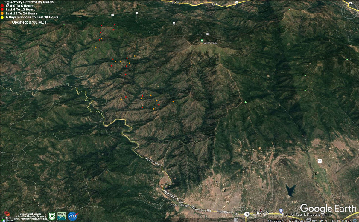
MODIS map of the Monument Fire on Saturday at 6:00 A.M PST
Note: 1,200 Pixels Wide - Note: Older Yellow not shown
MODIS Active Fire Mapping Program Frequently Asked Questions
Update: Monument Fire Evacuation Information & Updates for Saturday, September 4, 2021
September 4, 2021 - Monument Fire Update for Saturday Morning, 178,793 acres with 35% containment.
Monument North Zone Fire and Knob Fire Update
MONUMENT FIRE RESOURCES: 2,477 personnel, 41 hand crews, 154 engines, 20 helicopters, 49 dozers, 53 water tenders, 19 masticators
KNOB FIRE RESOURCES: 248 personnel, 7 hand crews, 24 engines, 4 dozers, 3 water tenders.
CURRENT SITUATION: The Monument fire is estimated at 178,793 acres and 35% contained. The Knob Fire is estimated at 2,798 acres and 82% contained. The priorities continue to be the Knob Fire and the southwest portion of the Monument Fire north of Hyampom Road.
Monument Fire North Zone: Last night fire activity moderated with no active runs. Interior pockets of unburned trees continued to burn. On the southwest perimeter crews conducted strategic firing operations to strengthen lines along Pattison Ridge.
Today on the southwest flank, crews will continue to work along Pattison Ridge to improve contingency lines to the south of Hyampom Road. At the North Fork Trinity River, crews will continue with handline southwards along Backbone Ridge to support operations in the area. To the west, crews will continue to patrol Corral Bottoms, Burnt Ranch and New River. Crews will patrol north of State Route 299 and extinguish visible hotspots.
Monument Fire South Zone (including the communities of Weaverville, Hayfork and Junction City): Please visit the CAL FIRE Shasta -Trinity Unit Facebook page at https://www.facebook.com/CALFIRESHU
Knob Fire: Last night, fire activity was minimal, and crews continued to improve containment lines along the perimeter of the fire. Today’s focus will be to strengthen containment lines and extinguish hot spots.
WEATHER: A high pressure system has formed over the forecasted area. This will bring hotter temperatures and drier conditions which may increase fire behavior. Relative humidity may dip into single digits.
ROAD CLOSURES AND RESTRICTIONS:
Monument Fire: State Route 299 - The eastside Monument Fire closure on State Route 299 has now been moved just west of Rose Road and Big Flat Campground. The west side closure point remains in place in Burnt Ranch just east of School House Road. Traffic will be lead through the Monument Fire closure every 1.5 hours beginning at 7:00 A.M. with the last opening scheduled for 7:00 P.M., Monday through Friday. For Labor Day weekend (Saturday, September 4 through Monday, September 6), traffic openings will be at the top of every hour between 7:00 A.M. and 7:00 P.M. During the Nighttime hours 7:00 P.M. to 7:00 A.M. only emergency personnel and residents with proof of residency will be allowed to travel on the road.
Other Road Closures: Hyampom - Hyampom Road at Nine Mile Bridge east to Hyampom Road at Cedar Creek Road. Hayfork - Carr Creek Road, Barker Creek Road, Barker Valley Road and Big Creek Road. Burnt Ranch - State Route 299 between Helena and Burnt Ranch are subject to intermittent closures. Junction City - Soldier Creek Road. Big French Creek north of State Route 299 and Big Mountain Road.
Knob Fire Road Closures: Willow Creek: China Creek Road at Hodgson Road, Burwood Drive, Gypo Lane, Friday Ridge Road, Panther Road and Butterfly Road.
MONUMENT FIRE EVACUATION ORDERS: Hayfork - Brady Road - West from Brady Road to Nine Mile Bridge, including Highland Drive, and all roads off of Highland Drive, Cedar Gulch.
KNOB FIRE EVACUATION ORDERS: Areas east of Brushy Mountain Lookout Road/FS Road 6N08A to State Route 299, south of Victor Creek to Butterfly Creek Road. Areas east of Brushy Mountain Lookout Road/FS Road 6N08A to the Trinity River, south of Butterfly Creek Road to the end of FS Road 6N20.
KNOB FIRE EVACUATION WARNINGS: Areas east of Boise Creek to the Humboldt/Trinity County Line, south of the Trinity River to Victor Creek. All areas east of State Route 299 to the Trinity River, south of Butterfly Creek Road to Friday Ridge Road. Salyer – All of South Fork Road, south of State Route 299.
For more information on current impact and evacuation areas, please go to humboldtsheriff.org, visit @HumCoOES on Facebook and Twitter, or call 707-268-2500.
MONUMENT FIRE EVACUATION WARNINGS: Hayfork – Everything north of State Route 3, from Brady Road to Hayfork Summit. Hayfork – Everything South of State Route 3, from Hayfork Summit to State Route 3 at Hyampom Road and State Route 3 at Tule Creek Road. Everything off of Morgan Hill Road, and Oak Avenue. Areas between Oak Avenue and State Route 3. Junction City – the end of Dutch Creek Rd. Coffee Creek and Trinity Center - all areas west of State Route 3 from Long Canyon to Rams Horn Rd; Coffee Creek proper and Trinity Center proper. Big Flat, Big Bar, and Del Loma. Trinity Village, Hawkins Bar and Denny.
EVACUATION CENTERS:
Monument Fire: McKinleyville Seventh Day Adventist, 1200 Central Avenue, McKinleyville, CA; Fireman’s Hall Pavilion, 9 Park Street, Fortuna, CA; First Baptist Church, 1261 Main Street, Weaverville, CA.
Knob Fire: McKinleyville Seventh Day Adventist, 1200 Central Avenue, McKinleyville, CA; First Baptist Church, 1261 Main Street, Weaverville, CA.
FOREST CLOSURE: Due to extreme fire conditions and lack of additional fire resources, the USDA Forest Service has temporarily closed all National Forests in California, including the Shasta-Trinity and Six Rivers National Forests. Questions can be directed to https://www.fs.usda.gov/main/r5/about-region/offices or by calling 707-562-9113 or email SM.FS.R5inquiries@usda.gov.
ANIMAL EVACUATIONS: Domestic Animals: Trinity County Animal Shelter, located at 563 Mountain View St., Weaverville, CA (530- 623-1370) Domestic + Large Animals: Hoopa Rodeo Grounds on Pine Creek Road, Hoopa, CA.
PROPERTY DAMAGE ASSESSMENTS: Damage assessment teams have confirmed 50 structures have been destroyed. For questions or information regarding the status of your property, call Trinity County Office of Emergency Services (OES) at 530-623-8223.
Basic Information
| Current as of | 9/4/2021, 7:29:07 AM |
| Incident Type | Wildfire |
| Cause | Lightning |
| Date of Origin | Friday July 30th, 2021 approx. 06:00 PM |
| Location | Del Loma, CA near Monument Peak |
| Incident Commander | Rick Young, ICT1 CIIMT5 and Mike Parkes, ICT1 CAL FIRE IMT |
| Incident Description | Wildfire |
| Coordinates | 40.752 latitude, -123.337 longitude |
Current Situation
| Total Personnel | 2,477 |
| Size | 178,793 Acres |
| Percent of Perimeter Contained | 35% |
| Estimated Containment Date | Monday November 01st, 2021 approx. 08:00 AM |
| Fuels Involved |
The fire remains squarely within the 2008 Buckhorn, Eagle, Miners and Cedar Fire footprints. Type converted brush and a heavy dead and down component dominate most areas. Fuels to the north of Hayfork are characterized as widely spaced mixed conifer and grass. All live fuels are cured to levels normally seen in late September. |
| Significant Events |
Active fire behavior. High resistance to control, and weak transport winds reinforced smoke shading and delayed the peak burn period. A continued warm, dry airmass at the surface still supported steady fire spread in all fuel types. Fire growth was primarily a function of aggressive surface fire, short, uphill runs and roll out due to steep, complex terrain. Afternoon heating provided new growth opportunities west of Hayfork towards Hyampom. Additional expansion continued into well aligned topography north of the 299 corridor within the designated wilderness towards Green Mountain and Thurston Peaks. East of Hoboken, the fire continues to make a consistent flanking action along the south slopes of Big Mountain. South Zone-Observed Fire Behavior: Creeping, smoldering, with continued consumption of interior islands. |
Outlook
| Planned Actions |
The Shasta-Trinity National Forest has provided the following priorities: 1. Minimize eastern progression of fire towards Junction City and Weaverville, 2. Reduce impacts of southwestern progression to Hayfork and Hyampom while maintaining access to Hyampom, 3. Minimize impact for values at risk to the northwest side of the fire including Burnt Ranch, Hawkins Bar, Trinity Village, Bell Flat, Daily, and Denny. Provide structure defense for the communities of Burnt Ranch, Friedrich Road, Hawkins Bar, Trinity Village, Cedar Flat, Underwood Mountain, 9-Mile Bridge, and Bar 717. In the southwest segment of the fire, patrol and mop-up along Corral Bottom Road/47 Road and Prodigy site. Continue direct handline down Haypress Road. Continue developing and improving primary indirect line along Pattison Road to Pattison Ridge, Pattison Peak Road, down through Halfway Ridge and east to Jud Creek tying in at 9-Mile Bridge to connect with the South Zone. Provide structure defense for the communities from Helena east through Junction City and north along Canyon Creek and the East Fork of the North Fork River. Reinforce indirect line north of the New River from Happy Camp Mountain to the confluence of the Trinity River. Take action on any spots across and west of the New River. Prepare structures along the New River from Five Waters northward towards Denny. Continue to mop up and patrol along the south portion of the fire in Divisions NN and RR, north of Hayfork to the western zone break. Continue fire suppression repair in Div DD, HH, and NN. Begin planning for the demobilization of excess equipment and personnel. Branch 40: Prepare for firing operations along pre-established lines to keep fire from Hayfork and Hyampom. Perform firing operations from pre-established lines before fire breaches primary containment lines. Branch 10: Finish control from Hwy 299 north to Hobo Gulch. Patrol and mop-up along Helena and Hwy 299. Support South Zone with resources as needed in Hayfork. Branch 1: Patrol from Corral Bottom to Burnt Ranch. Monitor New River area for spotting. |
| Projected Incident Activity |
12 hrs: With diurnal nighttime winds and shorter days, fire behavior will gradually temper under locally "fair" relative humidity recovery. The contribution of fine fuels to fire spread will diminish throughout the burn period. Wind flow will continue to steer established, deep seated fire both west and east along the South Fork Trinity River corridor; sustaining an ongoing threat to the communities of Hyampom and Hayfork. Continued fire activity along the south slopes of Big Mountain will maintain a threat to the New River corridor, and the community of Hoboken. 24 hrs: Active fire behavior. High resistance to control. Expect continued active burning with "smoke delayed" burn periods past sunset. Very dry large fuels and fully available fine fuels will contribute to unimpeded growth where any fuel continuity exists and suppression resources do not. Daily diurnal wind flow will again steer established, deep seated fire mainly along the South Fork Trinity River corridor; providing an ongoing threat to the communities of Hayfork and Hyampom. Expect northerly spread into the high elevation wilderness below Green Mountain and Thurston Peaks. Continued active burning, north of Ironside Mountain, will represent a threat to Denny. |
Current Weather
| Weather Concerns |
Synopsis: With the upper level trough exiting to the east and high pressure building in its retreat, a persistent easterly push was experienced over the Monument Fire, delaying the typical diurnal wind shift and causing increased drying. High pressure building over the area contributed to weak winds aloft and a steady blanket of smoke today, which helped to moderate weather conditions. Observed: Max Temperatures: Mid 80s to low 90s Minimum Humidity: 11-22% 20 ft Winds: Upper Slopes & Ridges: ENE to ESE morning 2-4 mph gusts near 10 mph, becoming west-northwest 6-10 mph gusts 15-20 mph into the afternoon and evening. Trinity River Basin: Down-canyon 4-8 mph with gusts to 15 mph through 1300, then up canyon 3-5 mph gusts to 10 mph through 1500. Stronger up canyon/WNW 6-9 mph with gusts 15-20 in the afternoon and evening through 10 pm within the Trinity River Basin and across exposed ridges through midnight. Forecast: Breezy conditions will taper by the evening and transition to down canyon by midnight. Temperatures will fall into the 50s with moderate humidity recovery in drainages and fair across ridges. Smoky conditions will prevail throughout the weekend, especially in the mornings, as high pressure strengthens. A warming trend is expected into Monday with subsequent drier RH values. |
Click here for: California Monument Fire Friday, September 3, 2021 Updates
