


Note: Click Here for Saturday's Monument Fire Updates
Evening Update: Monument Fire Update for Friday evening, the fire has increased to 178,069 Acres with 35% Containment and 2,525 total personnel.
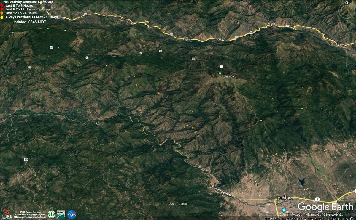
MODIS map of the Monument Fire on Friday at 5:45 A.M PST
Note: 1,200 Pixels Wide - Note: Older Yellow not shown
MODIS Active Fire Mapping Program Frequently Asked Questions
News: Disaster Unemployment Assistance Has Been Approved for Those Impacted by Widespread California Fires
Update: Monument Fire Evacuation Information & Updates for Friday, September 3, 2021
September 3, 2021 - Monument Fire Update for Friday Morning, 177,222 acres with 33% containment.
Basic Information
| Current as of | 9/3/2021, 6:17:35 AM |
| Incident Type | Wildfire |
| Cause | Lightning |
| Date of Origin | Friday July 30th, 2021 approx. 06:00 PM |
| Location | Del Loma, CA near Monument Peak |
| Incident Commander | Rick Young, ICT1 CIIMT5 and Mike Parkes, ICT1 CAL FIRE IMT |
| Incident Description | Wildfire |
| Coordinates | 40.752 latitude, -123.337 longitude |
Current Situation
| Total Personnel | 2,477 |
| Size | 177,222 Acres |
| Percent of Perimeter Contained | 33% |
| Estimated Containment Date | Monday November 01st, 2021 approx. 08:00 AM |
| Fuels Involved |
The fire remains squarely within the 2008 Buckhorn, Eagle, Miners and Cedar Fire footprints. Type converted brush and a heavy dead and down component dominate most areas. Fuels to the north of Hayfork are characterized as widely spaced mixed conifer and grass. All live fuels are cured to levels normally seen in late September. |
| Significant Events |
In Division RR, crews completed a firing operation along Hyampom Rd near Fox Ln and the Zone break. Crews continued to mitigate hazard trees, mop-up and patrol along control lines and around structures. Contingency lines were widened south of Hyampom rd. Mop up, gridding, backhaul, and tactical patrol continued in Division NN. Fire suppression repair and tactical patrols continued in DIV DD/HH. |
Outlook
| Planned Actions |
The Shasta-Trinity National Forest has provided the following priorities: 1. Minimize eastern progression of fire towards Junction City and Weaverville, 2. Reduce impacts of southwestern progression to Hayfork and Hyampom while maintaining access to Hyampom, 3. Minimize impact for values at risk to the northwest side of the fire including Burnt Ranch, Hawkins Bar, Trinity Village, Bell Flat, Daily, and Denny. Provide structure defense for the communities of Burnt Ranch, Friedrich Road, Hawkins Bar, Trinity Village, Cedar Flat, Underwood Mountain, 9-Mile Bridge, and Bar 717. In the southwest segment of the fire, patrol and mop-up along Corral Bottom Road/47 Road and Prodigy site. Continue direct handline down Haypress Road. Continue developing and improving primary indirect line along Pattison Road to Pattison Ridge, Pattison Peak Road, down through Halfway Ridge and east to Jud Creek tying in at 9-Mile Bridge to connect with the South Zone. Provide structure defense for the communities from Helena east through Junction City and north along Canyon Creek and the East Fork of the North Fork River. Reinforce indirect line north of the New River from Happy Camp Mountain to the confluence of the Trinity River. Take action on any spots across and west of the New River. Prepare structures along the New River from Five Waters northward towards Denny. Continue to mop up and patrol along the south portion of the fire in Divisions NN and RR, north of Hayfork to the western zone break. Continue fire suppression repair in Div DD, HH, and NN. Begin planning for the demobilization of excess equipment and personnel. Branch 40: Prepare for firing operations along pre-established lines to keep fire from Hayfork and Hyampom. Perform firing operations from pre-established lines before fire breaches primary containment lines. Branch 10: Finish control features from Hwy 299 north to Lobo Gulch. Patrol and mop-up along Helena and Hwy 299. Support South Zone with resources as needed in Junction City. Branch 1: Patrol from Corral Bottom to Burnt Ranch. Monitor New River area for spotting. |
| Projected Incident Activity |
12 hrs: With diurnal nighttime winds and shorter days, fire behavior will gradually temper under locally "fair" relative humidity recovery. The contribution of fine fuels to fire spread will diminish throughout the burn period. Wind flow will continue to steer established, deep seated fire both west and east along the South Fork Trinity River corridor; sustaining an ongoing threat to the communities of Hyampom and Hayfork. Continued fire activity along the south slopes of Big Mountain will maintain a threat to the New River corridor, and the community of Hoboken 24 hrs: Expect continued active burning with "smoke delayed" burn periods past sunset. Very dry large fuels and fully available fine fuels will contribute to unimpeded growth where any fuel continuity exists and suppression resources do not. Daily diurnal wind flow will again steer established, deep seated fire mainly along the South Fork Trinity River Corridor; providing an ongoing threat to the communities of Hayfork and Hyampom. Expect northerly spread into the high elevation wilderness below Green Mountain and Thurston Peaks. Continued active burning, north of Ironside Mountain, will represent a threat to Denny. |
Current Weather
| Weather Concerns |
Synopsis: Weak steering flow continued across the area today under a lingering upper-level trough. Light east ridge winds in the morning focused smoke across the Trinity River drainage and toward the coast. Better ventilation during the morning increased heating across portions of Branch 10 and Branch 30, where a couple of smoke plumes developed. As upcanyon winds developed in the afternoon, smoke shifted back to the east with peak gusts 15-20 mph at times as ridge winds transitioned to WNW. Temperatures warmed into the upper 80s to near 90 in the Trinity River basin to the 70s across ridges. with low humidity from 14-24%. Observed: Max Temperatures: 84-93 Minimum Humidity: 14-24% 20 ft Winds: Upper Slopes & Ridges: ENE to ESE morning 2-4 mph gusts near 10 mph, becoming west-northwest 6-10 mph gusts 15-20 mph into the afternoon and evening. Trinity River Basin: Down-canyon 1-3 mph through 1200, then upcanyon 3-5 mph gusts to 10 mph through 1500. Stronger upcanyon/WNW 6-9 mph with gusts 15-20 in the afternoon and evening through 10 pm within the Trinity River basin and across exposed ridges through midnight. Forecast: Breezy west-northwest and upcanyon winds will continue through the evening, then relax and become down-canyon by midnight. Light easterly flow will develop over the ridges through sunrise as temperatures fall into the 50s with good humidity recovery in drainages to moderate to poor across ridges as smoke settles back across the area. |
Click here for: California Monument Fire Thursday, September 2, 2021 Updates
