


Note: Click here for Friday's Monument Fire Updates
California Monument Fire Friday, September 3, 2021 Updates
Evening Update: Monument Fire Update for Thursday evening, the fire has increased to 176,463 Acres with 30% Containment and 2,477 total personnel.
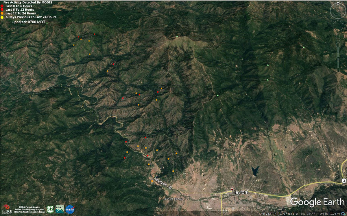
MODIS map of the Monument Fire on Thursday at 6:00 A.M PST
Note: 1,200 Pixels Wide - Note: Older Yellow not shown
MODIS Active Fire Mapping Program Frequently Asked Questions
*** Monument Fire ***
Reduction in North Hayfork and Southeast Hayfork - Effective Immediately (4:00 P.M.)
Reduced to Evacuation Warning:
North of Hyampom Rd. / SR 3, east of Cedar Gulch Rd., south of the fire’s edge, west of Brady Rd.
Removed from Warning (fully open):
North of Salt Creek Growers, east of Forest Ave., south of Morgan Hill Rd., west of Wildwood Rd.
Road Closures: Hyampom Rd. at Nine Mile Bridge east to Hyampom Rd. at Cedar Gulch Rd. (Closed)
The public needs to be aware there is still a concern for residual fire activity in these areas. Fire apparatus and crews will be observed in the area for several days or weeks. Fire activity can change rapidly and the public needs to be vigilant and be ready to move in case the Evacuation Status in the area changes.
Source: CAL FIRE Shasta-Trinity Unit
September 2, 2021 - Monument Fire Update for Thursday Morning, 176,579 acres with 29% containment.
Monument North Zone Fire and Knob Fire Morning Update
September 2, 2021
MONUMENT FIRE RESOURCES: 2,427 personnel, 38 hand crews, 170 engines, 20 helicopters, 55 dozers, 59 water tenders, 19 masticators
KNOB FIRE RESOURCES: 210 personnel, 7 hand crews, 18 engines, 1 dozer, 2 water tenders.
CURRENT SITUATION: The Monument fire is estimated at 176,759 acres and 29% contained. The Knob Fire is estimated at 2,179 acres and 52% contained. Today, the highest priorities are the Knob Fire and the southwest portion of the Monument Fire along Hyampom Road.
Monument Fire North Zone: Overnight fire activity was minimal and firefighters continued to improve contingency lines in the Hyampom Road area. Today, the focus is to continue strengthening contingency lines along Hyampom Road and to the south. Crews are also working to keep the fire in check and south of Pattison Ridge. On west portion of the fire, crews continue to patrol, mop up and look for hotspots from Corral Bottoms to Burnt Ranch. On Big Mountain, the fire continues to be active and is being monitored. In the northeast portion of the fire, resources completed the dozer line on Backbone Ridge and constructed handline down to the East Fork of North Fork Trinity River securing the contingency line. Today, crews are scouting for additional areas to build contingency lines east of Weaverville.
Monument Fire South Zone (including the communities of Weaverville, Hayfork and Junction City): Please visit the CAL FIRE Shasta -Trinity Unit Facebook page at https://www.facebook.com/CALFIRESHU
Knob Fire: The priority is to protect structures and infrastructure in and around Willow Creek. Fire crews had a successful night constructing containment lines along and above FS Road 6N13 in the direction of Brushy Mountain. Night crews were successful in securing containment line along State Route 299. Today crews will continue to build line on FS Road 6N13, as well as building a contingency line on Panther Ridge.
WEATHER: Very light winds over the fire area will continue to hamper smoke dispersal today. Smoke over the area may limit air operations on the Monument Fire.
ROAD CLOSURES AND RESTRICTIONS:
State Route 299-The east side of the Monument Fire closure on State Route 299 has now been moved just west of Rose Road and Big Flat Campground. The westside closure point remains in place in Burnt Ranch just east of School House Road. Traffic will be lead through the Monument Fire closure every 1.5 hours beginning at 7:00 A.M. with the last opening scheduled for 7:00 P.M., Monday through Friday. For Labor Day weekend (Saturday, September 4 through Monday, September 6), traffic openings will be at the top of every hour between 7:00 A.M. and 7:00 P.M. During the Nighttime hours 7:00 P.M. to 7:00 A.M. only emergency personnel and residents with proof of resident will be allowed to travel on the road.
Other Road Closures: Big French Creek north of State Route 299 and Big Mountain Road. Hayfork-Carr Creek Road, Barker Creek Road, Barker Valley Road and Big Creek Road. Burnt Ranch–State Route 299 between Helena and Burnt Ranch are subject to intermittent closures. Junction City-Soldier Creek Road.
MONUMENT FIRE EVACUATION ORDERS:
Hayfork-Brady Road – West from Brady Road to Nine Mile Bridge, including Highland Drive, and all roads off of Highland Drive, Cedar Gulch.
KNOB FIRE EVACUATION ORDERS:
Areas east of Brushy Mountain Lookout Road/FS Road 6N08A to State Route 299, south of Victor Creek to Butterfly Creek Road.
Salyer-All of South Fork Road, South of State Route 299.
MONUMENT FIRE EVACUATION WARNINGS: Hayfork – Everything north of State Route 3, from Brady Road to Hayfork Summit. Hayfork – Everything South of State Route 3, from Hayfork Summit to SR 3 at Hyampom Road and SR 3 at Tule Creek Road. Everything off of Morgan Hill Road, and Oak Avenue. Areas between Oak Avenue and State Route 3. Junction City – the end of Dutch Creek Rd. Coffee Creek and Trinity Center- all areas west of SR 3 from Long Canyon to Rams Horn Rd; Coffee Creek proper and Trinity Center proper. Big Flat, Big Bar, and Del Loma. Trinity Village, Hawkins Bar and Denny.
KNOB FIRE EVACUATION WARNINGS: China Creek and Friday Ridge areas near Willow Creek. Areas east of State Route 299 to the Trinity River, south of Panther Creek Road to Butterfly Creek Road. All areas east of Brushy Mountain Lookout Road/FS Road 6N08A to State Route Highway 299, south of Butterfly Creek Road to the end of FS Road 6N20. Areas east of State Route Highway 299 to the Trinity River, south of Butterfly Creek Road to Christian School Road, including residents on Christian School Road. Areas east of FS Road 6N33 to the Trinity River, south of Gypo Lane to Friday Ridge Road. All of South Fork Road in Salyer, south of State Route Highway 299, to the end of South Fork Road. Areas east of Boise Creek to the Humboldt/Trinity County Line, south of the Trinity River to Victor Creek.
EVACUATION CENTERS:
Monument Fire: McKinleyville Seventh Day Adventist, 1200 Central Avenue, McKinleyville, CA; Fireman’s Hall Pavilion, 9 Park Street, Fortuna, CA; First Baptist Church, 1261 Main Street, Weaverville, CA
Knob Fire: McKinleyville Seventh Day Adventist, 1200 Central Avenue, McKinleyville, CA; First Baptist Church, 1261 Main Street, Weaverville
FOREST CLOSURE: Due to extreme fire conditions and lack of additional fire resources, the USDA Forest Service has temporarily closed all National Forests in California, including the Shasta-Trinity and Six Rivers National Forests. Questions can be directed to https://www.fs.usda.gov/main/r5/about-region/offices or by calling 707-562-9113 or email SM.FS.R5inquiries@usda.gov.
ANIMAL EVACUATIONS: Domestic Animals: Trinity County Animal Shelter, located at 563 Mountain View St., Weaverville, CA (530- 623-1370) Domestic + Large Animals: Hoopa Rodeo Grounds on Pine Creek Road, Hoopa, CA.
PROPERTY DAMAGE ASSESSMENTS: Damage assessment teams have confirmed 50 structures have been destroyed. For questions or information regarding the status of your property, call Trinity County Office of Emergency Services (OES) at 530-623-8223.
Basic Information
| Current as of | 9/2/2021, 7:47:45 AM |
| Incident Type | Wildfire |
| Cause | Lightning |
| Date of Origin | Friday July 30th, 2021 approx. 06:00 PM |
| Location | Del Loma, CA near Monument Peak |
| Incident Commander | Rick Young, ICT1 CIIMT5 and Mike Parkes, ICT1 CAL FIRE IMT |
| Incident Description | Wildfire |
| Coordinates | 40.752 latitude, -123.337 longitude |
Current Situation
| Total Personnel | 2,362 |
| Size | 176,579 Acres |
| Percent of Perimeter Contained | 29% |
| Estimated Containment Date | Wednesday December 01st, 2021 approx. 08:00 AM |
| Fuels Involved |
The fire remains squarely within the 2008 Buckhorn, Eagle, Miners and Cedar Fire footprints. Type converted brush and a heavy dead and down component dominate most areas. Fuels to the north of Hayfork are characterized as widely spaced mixed conifer and grass. All live fuels are cured to levels normally seen in late September. |
| Significant Events |
Dry, breezy conditions from upper level winds transitioning from NW to NE brought active fire behavior. Consistent fire spread was observed in all fuel types, but accelerated in lighter fuels with a southwest exposures. Along the Highway 299 corridor fair relative humidity recovery after midnight tempered fire behavior in the lower elevations. Very active overnight fire growth was observed as north winds provided a spotting mechanism southward towards Hayfork. Elsewhere, fire progression was mostly seen in steeper terrain where intense backing fire and roll-out allowed the fire to make steady progress. |
Outlook
| Planned Actions |
The Shasta-Trinity National Forest has provided the following priorities: 1. Minimize eastern progression of fire towards Junction City and Weaverville, 2. Reduce impacts of southwestern progression to Hayfork and Hyampom while maintaining access to Hyampom, 3. Minimize impact for values at risk to the northwest side of the fire including Burnt Ranch, Hawkins Bar, Trinity Village, Bell Flat, Daily, and Denny. Provide structure defense for the communities of Burnt Ranch, Friedrich Road, Hawkins Bar, Trinity Village, Cedar Flat, Underwood Mountain, 9- Mile Bridge, and Bar 717. In the southwest segment of the fire, patrol and mop-up along Corral Bottom Road/47 Road and Prodigy site. Continue direct handline down Haypress Road. Continue developing and improving primary indirect line along Pattison Road to Pattison Ridge, Pattison Peak Road, down through Halfway Ridge and east to Jud Creek tying in at 9- Mile Bridge to connect with the South Zone. Provide structure defense for the communities from Helena east through Junction City and north along Canyon Creek and the East Fork of the North Fork River. Reinforce indirect line north of the New River from Happy Camp Mountain to the confluence of the Trinity River. Take action on any spots across and west of the New River. Prepare structures along the New River from Five Waters northward towards Denny. Continue construction of contingency line to protect the community of Hayfork. Continue mop up and patrol along the south portion of the fire in Divisions NN and RR, north of Hayfork. Evaluate equipment needs and allocate resources to Fire Suppression Repair as they become available. Knob Fire: Continue direct and indirect perimeter control to defend communities and keep fire as small as possible. Branch 40: Prepare for firing operations along pre-established lines to keep fire from Hayfork and Hyampom. Perform firing operations from pre-established lines before fire breaches primary containment lines. Branch 10: Finish control features from Hwy 299 north to Lobo Gulch. Patrol and mop-up along Helena and Hwy 299. Support South Zone with resources as needed in Junction City. Branch 1: Patrol from Corral Bottom to Burnt Ranch. Monitor New River area for spotting. |
| Projected Incident Activity |
Expect active fire growth under the influence of critically dry fuels. High resistance to control. Dry conditions will contribute to spotting and rapid, uphill runs. Predominant fire spread is anticipated in well aligned drainages on the north side of the Trinity River and from the eastern perimeter towards Junction City. Southern growth will threaten Hayfork, as western progression impacts Burnt Ranch and the New River drainage. 24 hours: Active fire behavior with high resistance to control. Fair overnight relative humidity recovery will temper the effect of the recent regional warming trend. Expect burn periods to expand with increased ventilation. Anticipate consistent, but lighter northwest winds to develop during the later part of the entire burn period to steer established, deep seated fire mostly west along the 299 corridor towards Burnt Ranch and the New River drainage, and south towards Hayfork. |
Current Weather
| Weather Concerns |
Observed Weather: Increased westerly flow ahead of an approaching upper level trough brought better ventilation of smoke this afternoon after a stronger morning inversion started to lift. Low temperatures ranged in the 50s to low 60s in thermal belts with humidity recovery of 25-40% on ridges and 60-80% in drainages. Stronger west winds elevated the strength of up-canyon winds, with peak gusts near 25 mph within aligned drainages and across exposed ridges during the late afternoon and into the evening. High temperatures ranged from the mid 90s in valleys to near 80 across ridges with minimum humidity in the 11-20% range. |
Click here for: California Monument Fire Wednesday, September 1, 2021 Updates
