


Note: Click Here for Dixie Fire Friday Updates
Update: Dixie Fire West Zone Virtual Community Meeting Evening Update Video for Thursday, September 9, 2021
Evening Update Per CAL FIRE: California Dixie Fire is at 928,741 Acres, with 59% Containment, and 4,809 personnel assigned for Thursday evening.
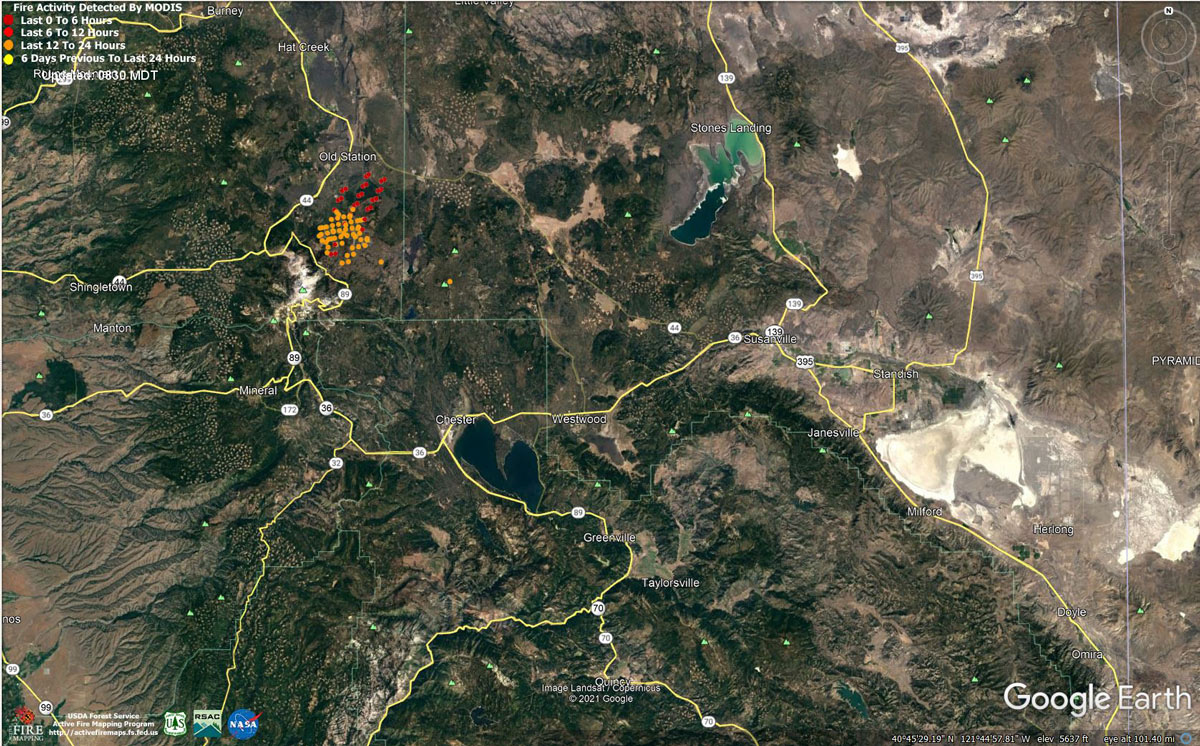 MODIS map of the Dixie Fire on Thursday at 7:30 A.M PST
Note: 1,200 Pixels Wide - Note: Older Yellow not shown
MODIS Active Fire Mapping Program Frequently Asked Questions
Update: For those residents evacuated in Eastern Shasta County due to the Dixie Fire. The Evacuation shelter is located at 37341 Main Street in Burney at the Word of Life Assembly Church.
Source: Shasta County Sheriff's Office
September 9, 2021 - Dixie Fire is 927,320 acres and 59% contained for Thursday morning.
CAL FIRE
'Click' here to view full PDF
Basic Information
| Current as of | 9/9/2021, 7:31:24 AM |
| Incident Type | Wildfire |
| Cause | Under Investigation |
| Date of Origin | Tuesday July 13th, 2021 approx. 05:15 PM |
| Location | Feather River Canyon near Cresta Powerhouse and Lake Almanor. |
| Incident Commander | Nick Truax, CALFIRE IMT 1; Evans Kuo, GBT1; Mike Minton, NPS |
| Incident Description | Wildfire |
| Coordinates | 39.819 latitude, -121.419 longitude |
Current Situation
| Total Personnel | 4,846 |
| Size | 927,320 Acres |
| Percent of Perimeter Contained | 59% |
| Estimated Containment Date | Saturday October 30th, 2021 approx. 12:00 AM |
| Fuels Involved |
Fuel moistures are historically low, Energy Release Components and BI are in the 97-99%. Northern California remains under a Fuels and Fire Behavior Advisory. |
| Significant Events |
Active Isolated Torching Running Backing The northern portion of the fire continued to burn actively north of Lassen Volcanic National Park. Active runs in the brush and understory with group torching and spotting on the northern portion of the fire were observed throughout the day. The southern portions of the fire continued to be active and burn interior islands. The needle cast continues to fall, creating a new layer of ground fuels, which occasionally ignite and smolder, threatening control lines. The bogs in the valley around Chester continue to smolder. |
Outlook
| Planned Actions |
Planned Actions for the next Operational Period: Priority areas include: the Lassen & Shasta Sectors, Old Station and surrounding communities, the Highway 395 escarpment area including Janesville, Milford and Herlong Junction as well as Lake Davis and the Grizzly Creek area east of the escarpment. Communities of Greenhorn, Cromberg and Davis Lake also at risk, see "East Zone:" below. Continue to establish direct and indirect containment lines south of Old Station, utilizing lines created during the Reading incident. Resources continue to establish containment lines to hold the Hwy 44 corridor and monitor for spots across the highway, while protecting critical fiber optic infrastructure. Complete contingency lines both north and south of Janesville and Milford respectively. Monitor weather for predicted wind event in the area. Provide structure defense, while ensuring firefighter safety. Provide for service calls within communities impacted by the fire: Chester, Hwy 36 corridor, Hwy 89 Corridor, Hwy 395 corridor, Paxton, Greenville, Jonesville, Crescent Mills, Taylorsville, Prattville, Butte Meadows, Bucks Lake, Meadows Valley, Rush Creek, Warner Valley, Pecks Valley, Williams Valley, Hunt Canyon, Susanville, Janesville, and the Greater Almanor area. Continued mop up of and patrol of 1,000-hr fuels will require a significant amount of resources due to the volume of fuels and the steep and rugged terrain. Continued holding actions and point protection of communities and critical infrastructure will require a significant resource presence for the next several operational periods. East Zone: Resources will continue hold and improve dozer and handline from Lake Davis to Clover Valley and construct dozer and handline to keep fire from spreading further into Dixie Valley, as well as south towards Clover Valley and Portola. East of Milford, construct direct and indirect containment lines on the NW and NE flanks of the fire south from Highway 395 to prevent fire from again impacting Milford and Highway 395. Construct dozer line in Dotta Canyon to the Sugar Fire scar as an alternate contingency line. Continue improving Road 177 and Beckwourth-Genesse Road as secondary control lines. Continue direct line construction in the Devil's Punchbowl area. Maintain containment, mop-up, and backhaul of equipment on western and central divisions in the Zone. Structure protection is in place within Genesee, Dixie Valley, Lake Davis area, Milford, and Taylorsville. |
| Projected Incident Activity |
12 hours: Fair overnight humidity recovery with overnight lows in the 50s to middle 60s. Stable conditions will trap smoke under the inversion. Moderate to active fire behavior due to hot, dry, and windy conditions. Man fire continues to burn out interior pockets in and around Horton Ridge, Dixie Valley, Squaw Peak, and the Diamond Mountains/395 corridor. Short range spotting potential remains in the active portions of the fire as well as the Squaw Peak area. 24 hours: Clouds will move in during the morning hours, increasing in the afternoon. This will cool temperatures and keep humidity above 15% in most areas. A Fire Weather Watch is in effect for Thursday night and Friday. Winds will strengthen and by late afternoon, the frontal wind will be in the valley bottoms, expect gusts to 27 mph on the ridges. There is a slight chance of thunderstorms with possible gusts to 45 mph. Showers may also develop in the late afternoon but should stay light. Moderate to active fire behavior due to windy conditions. Interior pockets will continue to burn together across the fire area and in the Dixie Valley area, Squaw Peak, and the Diamond Mountains/395 corridor. A cold front is expected to pass over the fire area starting at approximately 2000 hours, increasing the potential for spotting. Any new spots would establish and have rapid rates of spread. 48 hours: Fire Weather Watch continues as a cold front will pass through during the late night hours. As it does, some precipitation is likely, with a 40% chance of more than 0.10 inch, a 19% chance of more than 0.25. Overnight humidity will be nearing 100%. Temperatures will bottom out in the 40s. gusts will get as strong as 24 mph. Skies will clear rapidly Friday morning, allowing afternoon humidity to range from 15-25%. Afternoon temperatures will cool 10-15 degrees. Wind from the southwest with gusts as strong as 38 mph during the afternoon. thunderstorms are still possible on the extreme east end of the fire near the escarpment. Moderate to active fire behavior predominately in the Dixie Valley and Diamond Mountains/395 corridor. Spotting potential remains. Any new spots or starts would establish and have rapid rates of spread. 72 hours: Clearing skies and colder air will allow overnight lows to plummet to 30-40 degrees. Afternoon highs will start warming again. Gusts will once again be 20 mph or less. Humidity will trend lower. Moderate to active fire behavior expected. Anticipated after 72 hours: Expect nearly clear weather conditions to return. Both high and low temperatures will trend warmer through Monday. Afternoon wind will gust into the 20-25 mph range. Moderate fire behavior and activity expected. |
| Remarks |
Great Basin Incident Management Team 1 (GBT1) is in command of the East Zone. East Zone Unified Command Agencies: Plumas National Forest and Lassen National Forest. CAL FIRE IMT 1 is in command of the West Zone. West Zone Unified Command Agencies: Bureau of Land Management, CAL FIRE, Lassen National Forest, National Park Service. State DPA: 132,138; Federal DPA: 716,778; National Park DPA: 70,917; Local DPA: 424; DoD DPA: 3; BLM DPA: 1,932 The fire area is in portions of Butte, Lassen, Plumas, Shasta, and Tehama counties. Active fronts are in: Lassen NF, Lassen NP, and the Caribou Wilderness area; the Lake Davis and Antelope Lake area; highway 395 adjacent to Honey Lake area, as well as on several private timber ownerships. Structures possibly damaged in Dixie Valley area. Waiting on a Damage Inspection assessment to validate damage. East Zone - 7 responder injuries, West Zone - 3 responder injuries A State of Emergency for Butte, Lassen, and Plumas counties was declared by Governor Newsom on July 23rd, 2021. Butte, Lassen, Plumas, and Tehama Counties have declared local emergencies. FMAG has been approved for the Dixie Incident. Regional Order No. 21-07, effective August 31, 2021 through September 17, 2021, closes National Forest Service System lands within the Pacific Southwest Regions inclusive of Plumas and Lassen NFs. The Plumas National Forest implemented Forest Order No. 05-11-00-21-18, effective from July 25, 2021, through September 30, 2021. The Lassen National Forest implemented Forest Order No. 06-21-07, effective from July 27, 2021, through September 30, 2021. Additional values at risk threatened: National Scenic and Historic Trails: Pacific Crest Trail, Bizz Johnson National Recreation Trail. Inventory Roadless Area (IRAs): Bucks Lake (PNF), Butt Mountain (PNF), Chips Creek (LNF), and Cub Creek (LNF). Experimental Forests: Swain Mountain, Blacks Mountain. Research Natural Areas (RNAs): Green Island Lake(LNF), Soda Ridge (LNF), Cub Creek (LNF), Mount Pleasant (PNF). Air Quality impacts: Reno, Carson City, Susanville, Sparks, Fernley, and Quincy. Airports impacted by TFR and smoke impacts: Rogers Field (Chester Airport), Ganser Field (Quincy Airport), Westwood Airport, Susanville Municipal Airport, Herlong Airport. Wilderness: Bucks Lake Wilderness (PNF), Caribou Wilderness (LNF), Lassen Volcanic National Park Wilderness. Commercial timber ownerships: Sierra Pacific Industries, W.M. Beaty and Associates, Collins Pine. An estimated $1 Billion dollars of timber has already been destroyed with an additional $1 Billion still threatened. Substantial losses of private and public timberlands have released decades of sequestered carbon, releasing it into the atmosphere with uncalculatable impacts to green house gas accumulations. Waterways: Philbrook Lake (PG&E, LNF), North Fork of the Feather River (PG&E, PNF), Silver Lake (Drinking water, PNF), Thompson Lake (Drinking water, PNF), Butte Creek (T&E species: chinook and steelhead, PNF), Deer Creek (T&E species: chinook and steelhead), Oliver Lake (T&E species: Sierra-Nevada Yellow-legged Frog, LNF), Gold Lake (T&E species: Sierra-Nevada Yellow-legged frog, PNF), Rock Lake (T&E species: Sierra-Nevada Yellow-legged frogs, PNF) Additional T&E species (not listed above): California Spotted Owl, Valley Elderberry Beetle, Shasta Crayfish, Cascades frog, California Red-Legged Frog, Bald Eagle, Golden Eagle, Grey wolf, Fisher, California wolverine, and Sierra Nevada red fox. |
Current Weather
| Weather Concerns |
Hot weather continued today with temperatures reaching the middle 90s. Humidity stayed above 10% after an overnight humidity recovery of 30-40% on ridges and 60-70% in valleys. Wind from the southwest and west gusted as strong as 25 mph. The high did allow some cumulus to develop today, which was enhanced by heat on the north of the fire from active fire activity. |
Click here for: California Dixie Fire Wednesday, September 8, 2021 Updates
