


Note: Click here for Dixie Fire Saturday Updates
Update: Dixie Fire Informational Videos on Homeowners Right of Entry and Debris Removal After a Fire
Update: Dixie Fire East Zone Virtual Community Meeting Evening Update Video for Friday, September 10, 2021
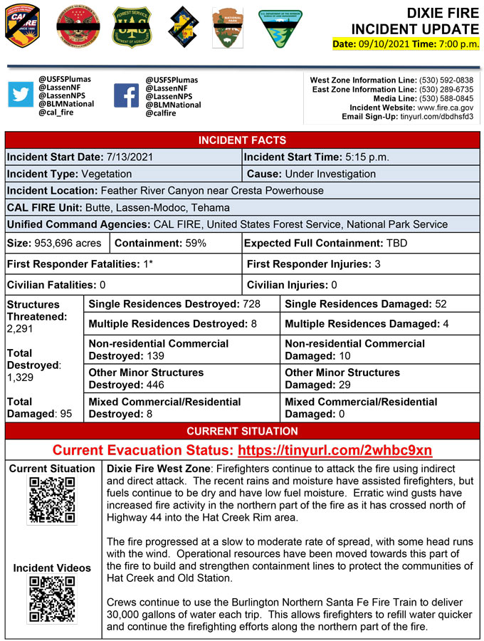
Evening Update Per CAL FIRE: California Dixie Fire is at 953,696 Acres, with 59% Containment, and 4,894 personnel assigned for Friday evening.
September 10, 2021 - Dixie Fire is 950,591 acres and 59% contained for Friday morning.
CAL FIRE
'Click' here to view full PDF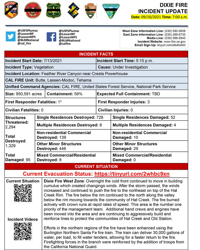
Basic Information
| Current as of | 9/10/2021, 7:26:48 AM |
| Incident Type | Wildfire |
| Cause | Under Investigation |
| Date of Origin | Tuesday July 13th, 2021 approx. 05:15 PM |
| Location | Feather River Canyon near Cresta Powerhouse and Lake Almanor. |
| Incident Commander | Nick Truax, CALFIRE IMT 1; Evans Kuo, GBT1; Mike Minton, NPS |
| Incident Description | Wildfire |
| Coordinates | 39.819 latitude, -121.419 longitude |
Current Situation
| Total Personnel | 4,809 |
| Size | 950,591 Acres |
| Percent of Perimeter Contained | 59% |
| Estimated Containment Date | Saturday October 30th, 2021 approx. 12:00 AM |
| Fuels Involved |
Fuel moistures are historically low, Energy Release Components and BI are in the 97-99%. Northern California remains under a Fuels and Fire Behavior Advisory. |
| Significant Events |
Extreme Long-range Spotting Short Crown Runs Running West Zone - The fire became very active early in the operational period with clear skies. The winds continued to move the fire to the northwest with active crown runs and medium to long range spotting. The fire crossed Highway 44 above the Hat Creek Rim becoming more exposed to the surfacing winds. The fire also progressed to the west and burned into the community of Old Station. East Zone - Interior pockets continue to burn out. Areas of heat near the perimeter. |
Outlook
| Planned Actions |
Planned Actions for the next Operational Period: Priority areas include: the Lassen & Shasta Sectors, Old Station and surrounding communities, the Highway 395 escarpment area including Janesville, Milford and Herlong Junction as well as Lake Davis and the Grizzly Creek area east of the escarpment. Communities of Greenhorn, Cromberg and Davis Lake also at risk, see "East Zone:" below. Continue to establish direct and indirect containment lines south of Old Station, utilizing lines created during the Reading incident. Resources continue to establish containment lines to hold the Hwy 44 corridor and monitor for spots across the highway, while protecting critical fiber optic infrastructure. Complete contingency lines both north and south of Janesville and Milford respectively. Monitor weather for predicted wind event in the area. Provide structure defense, while ensuring firefighter safety. Provide for service calls within communities impacted by the fire: Chester, Hwy 36 corridor, Hwy 89 Corridor, Hwy 395 corridor, Paxton, Greenville, Jonesville, Crescent Mills, Taylorsville, Prattville, Butte Meadows, Bucks Lake, Meadows Valley, Rush Creek, Warner Valley, Pecks Valley, Williams Valley, Hunt Canyon, Susanville, Janesville, and the Greater Almanor area. Continued mop up of and patrol of 1,000-hr fuels will require a significant amount of resources due to the volume of fuels and the steep and rugged terrain. Continued holding actions and point protection of communities and critical infrastructure will require a significant resource presence for the next several operational periods. East Zone: 1) Resources will continue hold and improve dozer and handline from Lake Davis to Clover Valley and construct dozer and handline to keep fire from spreading further into Dixie Valley, as well as south towards Clover Valley and Portola. 2) East of Milford, construct direct and indirect containment lines on the NW and NE flanks of the fire south from Highway 395 to prevent fire from again impacting Milford and Highway 395. Construct dozer line in Dotta Canyon to the Sugar Fire scar as an alternate contingency line. Continue improving Road 177 and Beckwourth-Genesse Road as secondary control lines. 3) Complete dozer line in Dotta Canyon to the Sugar Fire scar as an alternate contingency line. Continue improving Road 177 and Beckwourth-Genesee Road as secondary control lines. 4) Continue direct line construction in the Devil's Punchbowl area. 5) Maintain containment, mop-up, and backhaul of equipment on western and central divisions in the Zone. |
| Projected Incident Activity |
12 hours: The cold front continues to move through the area tonight, passing in the overnight hours. It will bring rain showers and isolated thunderstorms with gusty and erratic winds, lightning, and rain. Winds increase through the night with the passage of the front with gusts increasing to 40 mph on ridges. Red Flag Warning continues through the night. Active fire behavior due to Red Flag conditions. Interior pockets continue to burn together across the fire area and in the Dixie Valley area, Squaw Peak and the Diamond Mountains/395 corridor. Any new spots will establish and have rapid rates of spread. Threat of new IAs due with incoming dry lightning. 24 hours: Red Flag Warning continues. Friday storms and showers will be exiting the area by mid morning. Strong winds will continue until midday with gusts up to 40 mph on ridges in the morning. Winds will taper in the evening but will stay elevated into Saturday with gusts to 20 mph. Temperatures will stay cooler behind this cold front, but will begin to increase again Saturday. These general conditions should continue until Wednesday. Moderate to active fire behavior predominately in the Dixie Valley and Diamond Mountains/395 corridor. Spotting potential remains. There is a slight chance of thunderstorm development over the escarpment area (395 corridor). Any new spots or starts would establish and have rapid rates of spread. 48 hours: Clear skies will allow temperatures to lower into the 30s and 40s overnight with some high elevation basins getting below freezing. Humidity recovery will remain high, in excess of 60 percent, with afternoon readings of 12 to 21 percent. A warming trend also develops. Wind is much less with gusts to only 24 mph on the ridges. Moderate activity expected. Interior islands continue to burn out. 72 hours: Continued clear and cold for the night, with a continued drying trend to both humidity recovery and afternoon humidity. Sunday afternoon winds will gust to 18 mph. Moderate fire activity expected. Anticipated after 72 hours: Clear nights and sunny days continue through at least Wednesday. Gradual warming is expected with no significant wind forecast. Moderate fire behavior and activity expected. |
| Remarks |
Great Basin Incident Management Team 1 (GBT1) is in command of the East Zone. East Zone Unified Command Agencies: Plumas National Forest and Lassen National Forest. CAL FIRE IMT 1 is in command of the West Zone. West Zone Unified Command Agencies: Bureau of Land Management, CAL FIRE, Lassen National Forest, National Park Service. The fire area is in portions of Butte, Lassen, Plumas, Shasta, and Tehama counties. Active fronts are in Lassen NF, Lassen NP, and the Caribou Wilderness area; the Lake Davis and Antelope Lake area; Highway 395 adjacent to Honey Lake area, as well as on several private timber ownerships. East Zone - 7 responder injuries; West Zone - 3 responder injuries A State of Emergency for Butte, Lassen, and Plumas counties was declared by Governor Newsom on July 23rd, 2021. Butte, Lassen, Plumas, and Tehama Counties have declared local emergencies. FMAG has been approved for the Dixie Incident. Regional Order No. 21-07, effective August 31, 2021 through September 17, 2021, closes National Forest Service System lands within the Pacific Southwest Regions inclusive of Plumas and Lassen NFs. The Plumas National Forest implemented Forest Order No. 05-11-00-21-18, effective from July 25, 2021, through September 30, 2021. The Lassen National Forest implemented Forest Order No. 06-21-07, effective from July 27, 2021, through September 30, 2021. Additional values at risk threatened: National Scenic and Historic Trails: Pacific Crest Trail, Bizz Johnson National Recreation Trail. Inventory Roadless Area (IRAs): Bucks Lake (PNF), Butt Mountain (PNF), Chips Creek (LNF), and Cub Creek (LNF). Experimental Forests: Swain Mountain, Blacks Mountain. Research Natural Areas (RNAs): Green Island Lake(LNF), Soda Ridge (LNF), Cub Creek (LNF), Mount Pleasant (PNF). Air Quality impacts: Reno, Carson City, Susanville, Sparks, Fernley, and Quincy. Airports impacted by TFR and smoke impacts: Rogers Field (Chester Airport), Ganser Field (Quincy Airport), Westwood Airport, Susanville Municipal Airport, Herlong Airport. Wilderness: Bucks Lake Wilderness (PNF), Caribou Wilderness (LNF), Lassen Volcanic National Park Wilderness. Commercial timber ownerships: Sierra Pacific Industries, W.M. Beaty and Associates, Collins Pine. An estimated $1 Billion dollars of timber has already been destroyed with an additional $1 Billion still threatened. Substantial losses of private and public timberlands have released decades of sequestered carbon, releasing it into the atmosphere with uncalculatable impacts to green house gas accumulations. Waterways: Philbrook Lake (PG&E, LNF), North Fork of the Feather River (PG&E, PNF), Silver Lake (Drinking water, PNF), Thompson Lake (Drinking water, PNF), Butte Creek (T&E species: chinook and steelhead, PNF), Deer Creek (T&E species: chinook and steelhead), Oliver Lake (T&E species: Sierra-Nevada Yellow-legged Frog, LNF), Gold Lake (T&E species: Sierra-Nevada Yellow-legged frog, PNF), Rock Lake (T&E species: Sierra-Nevada Yellow-legged frogs, PNF) Additional T&E species (not listed above): California Spotted Owl, Valley Elderberry Beetle, Shasta Crayfish, Cascades frog, California Red-Legged Frog, Bald Eagle, Golden Eagle, Grey wolf, Fisher, California wolverine, and Sierra Nevada red fox. |
Current Weather
| Weather Concerns |
High pressure transitioned to an incoming cold front with showers developing in the afternoon. Instability and very active fire led to pyrocumulus developing with a column of smoke being sent northeast due to strong winds aloft. Winds increased on the surface as well, with southwest wind across the fire today gusting to around 20 mph. Temperatures still were hot in the upper 80s to low 90s with RH 15-25% across the fire. These conditions prompted the issuance of Red Flag Warnings for the fire. |
Click here for: California Dixie Fire Thursday, September 9, 2021 Updates
